Patagonia Torres Del Paine Glaciers End Of World — Facts From Upstairs travel guide

Patagonia, Argentina: Torres del Paine, Perito Moreno Glacier & Edge of the World

Patagonia, Argentina: Torres del Paine, Perito Moreno Glacier & Edge of the World

The planet’s most dramatic wilderness where mountains meet ice sheets at the world’s end

Facts From Upstairs Travel | 8-minute read | Updated March 2026

3,050m
Torres del Paine Peak Elevation
250 km²
Perito Moreno Glacier Area
50m
Typical Annual Glacier Recession
2000+ years
Documented Patagonian Occupation

Patagonia exists at the threshold of habitable Earth. The region—encompassing southern Argentina and Chile—extends toward Antarctica, creating landscapes where human presence feels incidental. Massive mountain ranges, including the Torres del Paine, rise sharply from glaciated valleys. Vast ice sheets—the largest in the Southern Hemisphere outside Antarctica—cover valleys and extend toward the sea. The climate alternates between fierce wind and deceptive calm. The vegetation transitions from temperate forest to sparse steppe. Wildlife includes guanacos (wild relatives of llamas), pumas, and birds found nowhere else.

Patagonia, Argentina

Patagonia’s appeal lies in its extremity and remoteness. Modern tourism has made the region increasingly accessible—reliable lodges, organized tours, and developed trails—yet the fundamental wildness persists. The famous W Trek in Torres del Paine National Park draws thousands annually, yet departure from marked trails leads immediately to genuine wilderness. The Perito Moreno Glacier, one of the world’s few advancing glaciers, demonstrates ice dynamics on dramatic scales. The region rewards those willing to endure uncomfortable conditions for unparalleled natural immersion. Patagonia strips away comfort and confronts you with Earth’s beauty indifferent to human presence.

Patagonia is not mountains and glaciers in isolation. It’s the interconnected system—wind, water, ice, rock, and vegetation—creating conditions so extreme that the landscape challenges human perception. The scale overwhelms; the beauty humbles.

Torres del Paine: Iconic Granite Peaks

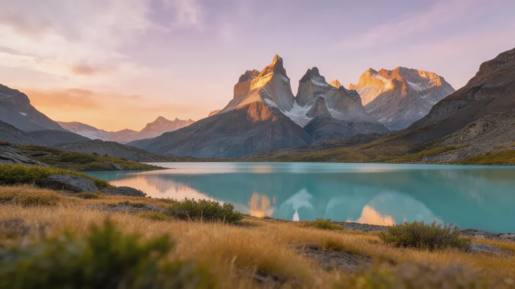
Torres del Paine—”towers of blue”—comprises three granite peaks reaching 3,050 meters, rising dramatically from glaciated valleys. The formation’s distinctive appearance—sheer vertical granite faces—creates instantly recognizable silhouette. The mountains dominate Paine National Park’s landscape, visible from dozens of angles depending on location. The clarity of air at southern latitudes creates visibility extending to impossible distances, making distant mountains appear closer than they actually are.

The Torres themselves, accessible via the Valley of the Towers hike, require technical rock climbing for summit achievement. Most visitors experience the towers through hiking and photography from accessible vantage points. The primary destinations—French Valley hike and Towers approach—offer stunning views without climbing requirement. The landscape—glaciated valleys, hanging glacier remnants, and windswept steppe—remains visually extraordinary despite moderate hiking difficulty.

The mountains’ granite geology, exposed by glacial carving during ice ages, represents incredibly ancient rock. The granite crystallized 200+ million years ago. Subsequent uplift and glaciation shaped the current dramatic form. Walking these trails traverses literally ancient stone while witnessing ice-age processes (glaciers and valleys) still actively reshaping landscape.

⛰️
Fun Fact: Paine means “blue” in the indigenous Tehuelche language. The peak name reflects colors visible from certain angles and light conditions. The mountains change color dramatically throughout the day—grey-blue in early morning, brilliant white under midday sun, orange and red during sunset.
Pro Tip: Visit Torres del Paine during December-February (southern summer) for best weather, though conditions remain unpredictable. Wind gusts exceeding 100 km/hour occur regularly. Pack weather-resistant gear regardless of forecast. The W Trek requires advance booking during peak season. Entry fees (approximately 80 USD for non-citizens) are substantial but support park maintenance.

Perito Moreno Glacier: Advancing Ice

Perito Moreno Glacier, one of the world’s few advancing glaciers, flows from the southern Patagonian ice field into Lago Argentino. The glacier’s advance and retreat cycles—unusual in the context of global warming causing most glacier retreat—create dramatic ice-calving spectacles. Massive chunks of ice, breaking from the glacier’s advancing front, crash into the lake with thunderous explosions. The frequency of calvings varies from days apart to multiple daily events.

The glacier’s dimensions overwhelm perception. The face rises 60+ meters above lake level. The glacier’s thickness exceeds 700 meters. The advancing edge moves forward approximately 2 meters daily, meaning the glacier advances despite global warming trends affecting other glaciers negatively. The mechanism—abundant precipitation in the accumulation zone, combined with steep descent facilitating ice flow—maintains positive mass balance.

Viewing options range from platform viewpoints near the lodge to boat trips approaching close to the glacier face. The sound of calving—amplified across water—conveys the ice’s power. Witnessing major calvings creates lasting impressions. The combination of visual spectacle (ice blocks larger than buildings launching into the lake) with visceral sound and physical impact generates awe exceeding typical nature observation.

Perito Moreno Glacier

Approximately 50 km from El Calafate. Accessible by vehicle with short walks. Platform viewpoints offer dramatic perspectives. Boat trips provide closer approach. Ice trekking options available (moderate physical demand).

Upsala Glacier

Adjacent glacier visible during boat excursions. Currently retreating, unlike Perito Moreno. The contrast between advancing and retreating glaciers within visible distance illustrates climate change’s varied impacts.

🧊
Fun Fact: Perito Moreno’s advance-retreat cycle has been documented for 150+ years. The glacier periodically advances across Lago Argentino, creating dams that raise lake levels catastrophically. When pressure becomes extreme, the ice dam collapses, generating massive water releases called “sudestada” events.
Pro Tip: Spend entire day at Perito Moreno. Morning visits reduce crowds. Afternoon light creates better photographs. Even days without major calvings offer visual spectacle through smaller ice breaks and light effects on the glacier face. Wear sun protection—glacier ice reflects intense UV radiation.

The W Trek: Mountain Pilgrimage

The W Trek, named for its trajectory connecting five valleys forming a W-shape on maps, constitutes the most popular multi-day Patagonia trek. The four-day version (extended trips approach 8 days) covers approximately 50 kilometers of marked trail connecting distinct ecosystems and viewpoints. Days involve typically 7-9 hours hiking, ascending and descending elevation repeatedly. The route ascends the Grey Valley toward Grey Glacier, traverses to Pehoe Lake viewpoints, continues to the iconic Torres del Paine towers, extends to French Valley beneath Mount Paine, and concludes near Cuernos del Paine.

The trek accommodates various fitness levels. The terrain—well-marked trails with mostly moderate grades—remains accessible to reasonably fit hikers without mountaineering experience. The challenge emerges from duration, elevation changes, and unpredictable weather. Fierce winds sometimes restrict progress; hail or snow can appear in summer. The remote environment means assistance if injured or exhausted could require significant time.

Lodge-based trekking (sleeping in established refugios rather than camping) reduces difficulty. The lodges provide meals, allowing hikers to travel light, and eliminate weather camping concerns. The social aspect—meeting other trekkers at lodges—creates community experience. The combination of natural immersion, physical challenge, and social gathering makes the W Trek more than individual hiking accomplishment.

🥾
Fun Fact: The W Trek’s popularity—attracting several thousand annually—creates conservation concerns. Park authorities implement entry quotas and trail maintenance requirements. The trek has evolved from obscure wilderness route to organized tourism infrastructure maintaining the experience quality while managing environmental impact.
Pro Tip: Book lodges 3-6 months in advance for peak season. Join a guided group if uncertain about navigation or logistics. Pack waterproof layers for absolutely every day—weather changes occur rapidly and unpredictably. Fuel portable hiking stoves rather than campfire fires. Start early daily to maximize daylight. Physical preparation through training hiking weeks before the trek eases the experience substantially.

Wildlife & Ecosystems: Patagonian Life

Patagonian wildlife adapted to extreme conditions. Guanacos (wild relatives of domesticated llamas), standing 1.5 meters tall, roam the steppe in small herds. Pumas hunt guanacos but remain rarely observed by humans. Huemuls (Andean deer), critically endangered, inhabit mountain regions. Rheas (flightless birds resembling ostriches) appear on the steppe. Condors—massive vultures with three-meter wingspans—soar on wind currents. The fauna represents biodiversity persistence despite harsh conditions.

Vegetation transitions dramatically across the region. Evergreen Patagonian forests, dominated by southern beech trees, cover western slopes receiving moisture from Pacific storms. The forests’ density and dark coloration create distinctive character. Descending eastward, vegetation thins as precipitation decreases. The steppe—sparse, wind-sculpted vegetation adapted to extreme drying—reflects the continental climate creating arid conditions despite appearing temperate.

The ecosystem’s balance remains fragile. Introduced species (beavers, mink, foxes) damage native environments. Overhunting historically devastated guanaco populations. Climate change threatens entire ecosystem stability. Visiting Patagonia includes confronting these conservation challenges alongside appreciating wilderness value.

🦌
Fun Fact: Condors, among Earth’s longest-lived birds, can survive 60+ years in the wild. Patagonian populations, once nearly extinct, have recovered through conservation efforts. Witnessing a condor—its enormous wingspan and graceful flight—creates unmistakable impression of power and freedom.

Access & Logistics: Reaching the Remote

Patagonia’s remoteness manifests in access challenges. El Calafate, the primary gateway for glacier visits, is reachable via flights from Buenos Aires (flights approximately 3 hours). El Chaltén, gateway to Fitz Roy mountain and extended trekking, requires bus travel from Calafate (approximately 3 hours). Puerto Natales (Chile) serves as gateway for Torres del Paine and generally requires entrance via Chilean points.

The region’s remoteness creates higher expenses than other Argentine destinations. Accommodation costs exceed Buenos Aires by substantial margins. Food prices reflect supply-chain challenges. Tour prices reflect guide expertise and small customer numbers. Budget 150-300 USD daily for mid-range accommodations and meals (tourist-oriented establishments, not local prices).

Weather can delay travel plans dramatically. Wind gusts exceeding 100 km/hour sometimes prevent boat operations or make trekking dangerous. Buses occasionally don’t operate when snow blocks southern routes. Flexibility regarding travel dates significantly eases logistics. Booking accommodations and tours through established operators reduces uncertainty.

✈️
Fun Fact: Patagonia’s wind strength is notorious. The prevailing westerlies create consistent wind from the west, particularly intense during afternoon hours. Wind strengths occasionally reach hurricane-force speeds, creating the planet’s windiest regions outside polar areas.

El Calafate & El Chaltén: Gateway Towns

El Calafate, home to approximately 30,000 residents, functions as the primary gateway for glacier tourism. The town has modernized significantly, developing tourism infrastructure—hotels, restaurants, and tour operators—to accommodate increasing visitors. The town maintains some Argentine frontier character but increasingly reflects tourist-town commercialization. The climate—wind, dryness, sparse vegetation—creates austere landscape even in town.

El Chaltén, further north, maintains somewhat grittier character. The town attracts outdoor enthusiasts, mountaineers, and younger backpackers. The community, established in 1985 as an Argentine territorial claim against Chilean territory, remains smaller and less developed than Calafate. Accommodations and restaurants exist but reflect more casual, less commercialized character. The town serves as base for Fitz Roy mountain trekking and secondary base for Patagonia exploration.

Both towns require acceptance of their function as tourist infrastructure. Neither maintains pristine character—they exist to serve visitors accessing Patagonian wilderness. The towns provide essential services while remaining somewhat removed from the dramatic natural environments surrounding them. The contrast—functional gateway towns versus overwhelming wilderness—reinforces Patagonia’s fundamental character.

🗻
Fun Fact: Fitz Roy, located near El Chaltén, reaches 3,405 meters and represents one of South America’s most photographed mountains. The peak’s distinctive shape—resembling a flame or pyramid—creates instantly recognizable silhouette. The mountain presents serious climbing challenges, particularly in descent routes.
💨
Fun Fact: Patagonian wind strength, combined with harsh sunlight and extreme dryness, creates brutal environmental conditions. The wind—persistent, powerful, and inescapable—becomes character-defining. Experienced travelers arrive with proper wind-resistant gear prepared for conditions exceeding typical hiking challenges.
🌍
Fun Fact: Patagonia’s location at 51°S latitude places it only approximately 2,000 kilometers from Antarctica. The region experiences extreme seasonal variation—summer (December-February) offers 16+ hours of daylight; winter plunges into darkness with only 8-9 hours of daylight. The latitude contributes to extreme climate.

Ready for Patagonia?

Prepare physically through training hikes. Book accommodations and tours months in advance. Pack weather-resistant, wind-proof gear for every season regardless of forecast. Bring sun and wind protection despite appearing remote. Budget generously—Patagonia is expensive. Embrace unpredictability and delays as part of the experience. Prioritize safety over schedule. Patagonia rewards those willing to accept discomfort, endure uncertainty, and embrace Earth’s power indifferent to human presence. The region’s extreme beauty justifies every challenge.

Scroll to Top
FFU Editorial Letter

A new guide in your inbox each week

Magazine-quality, on-the-ground travel intelligence. No spam, no recycled lists, unsubscribe anytime.