Tasmania, Australia: Wilderness Walks, Tasmanian Devils & Cradle Mountain
Explore Australia’s wild southern frontier where pristine forests, alpine peaks, and unique wildlife create unforgettable wilderness experiences
Tasmania, Australia’s island state positioned 240 kilometers south of mainland Australia across the Bass Strait, functions as the southern continent’s wilderness frontier. The island comprises approximately 68,000 square kilometers, making it comparable to Ireland in area, yet hosts only 540,000 residents—a population density approximating sparse wilderness rather than industrial development. This demographic reality means that vast tracts remain relatively undisturbed by human activity, with over 40 percent of Tasmanian land protected as national parks, nature reserves, or World Heritage Areas. The island’s isolation, rugged topography, and cool maritime climate created unique evolutionary conditions producing animal and plant species found nowhere else globally.

Tasmanian identity centers on wilderness preservation and environmental commitment. Decades of conservation activism established Tasmania internationally as a model for protected landscape management. The island’s rivers remain among Earth’s last free-flowing systems, its forests contain some of the tallest hardwood trees alive, and its coastal waters support marine ecosystems largely untouched by commercial exploitation. This environmental stewardship ethos permeates contemporary Tasmanian society—locals discuss conservation policy with passionate engagement that would seem unusual in many populations, reflecting genuine collective investment in preserving the landscape defining their identity and home.
What You’ll Discover
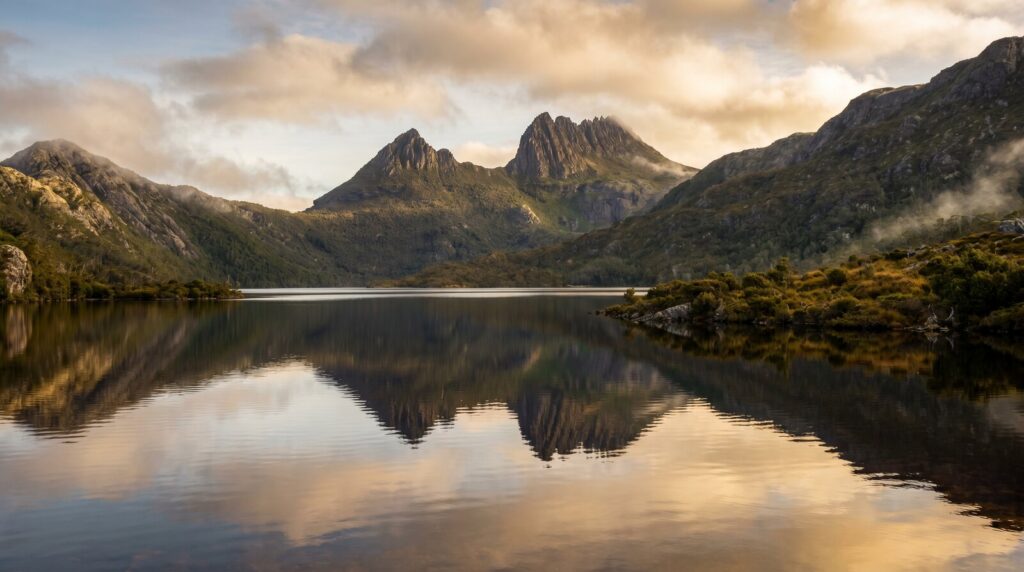
Cradle Mountain & Alpine Wilderness
Cradle Mountain, rising 1,545 meters above sea level, anchors the northwestern Tasmanian landscape and serves as the primary destination for visitors seeking alpine wilderness. The mountain’s distinctive profile—sharp ridges rising from surrounding terrain—has made it a Tasmanian icon featured on tourism promotion material and in countless photographs. The view from Dove Lake at mountain base captures the peak’s majesty, with the lake’s mirror surface reflecting the craggy summit when calm weather permits. The walk around Dove Lake requires roughly two hours at moderate pace, making it accessible to visitors with modest fitness levels while providing stunning imagery justifying the effort.
More ambitious hikers ascend Cradle Peak itself through a steep, rock-strewn trail reaching the summit in approximately six hours round-trip. The ascent climbs over 1,000 meters elevation, demanding fitness and suitable footwear. The reward encompasses 360-degree views spanning Tasmania’s central highlands, with visibility on clear days extending to Barn Bluff, Winter Bluff, and Hanson Peak—a collection of dramatic peaks creating the landscape’s distinctive alpine character. Weather deteriorates rapidly at altitude; conditions can transform from clear to dangerous in minutes, necessitating weather awareness and prepared descent capability regardless of summit achievement goals.
The Cradle Mountain-Lake St. Clair National Park encompasses approximately 161,000 hectares protecting alpine plateaus, temperate rainforest, button grass moorland, and glacially-carved valleys. The park hosts numerous walking tracks ranging from easy strolls to challenging multi-day routes. Weindorfers Lodge, constructed in 1912 at Cradle Mountain’s base, operates as accommodation and historical landmark. The small lodge building illuminates early 20th-century wilderness tourism practices and reflects the vision of entrepreneurs who recognized the landscape’s value for tourism before environmental protection became mainstream cultural priority.
Hanson Peak, while slightly lower than Cradle Peak, offers superior panoramic opportunities with less technical climbing. The walk ascends from Cradle Mountain area through diverse vegetation zones—starting in subalpine scrubland, transitioning through alpine heath, and concluding in exposed rock terrain. The diverse habitats illustrate how elevation creates rapid ecological transitions condensing landscape variety typically spread across hundreds of kilometers of horizontal distance.
Multi-Day Hiking Trails
Tasmania hosts numerous multi-day walking tracks traversing protected wilderness areas. The Overland Track, Tasmania’s most famous multi-day walk, spans approximately 65 kilometers from Cradle Mountain south to Lake St. Clair over five to six days. The track traverses diverse terrain—alpine plateaus, temperate rainforest, button grass moorland, and glacial valleys—providing compressed experience of Tasmanian ecological diversity. Approximately 8,000 walkers annually attempt the route, making it well-established and reasonably easy to follow, though weather unpredictability and physical demands remain significant.
The Overland Track’s appeal transcends mere physical accomplishment. The track traverses through landscapes offering solitude, challenge, and authentic wilderness encounter. Huts positioned approximately 13-17 kilometers apart allow hikers to carry minimal gear while maintaining shelter availability. Walkers encounter similar-capability companions daily, frequently developing friendships intensified through shared physical challenge and natural setting. The five-day immersion in wilderness produces psychological shifts—the constant minor stresses of modern life recede replaced by present-moment focus on weather, terrain, physical sensation, and landscape observation.
The South Coast Track presents an alternative multi-day experience emphasizing coastal and forest ecosystems rather than alpine terrain. The 86-kilometer route follows the island’s southern coastline, incorporating beach walking, rainforest traversal, and river crossings. The walk typically requires 7-8 days and presents navigation challenges including tidal considerations and route-finding through less-developed track sections. The remoteness, shorter overall walker numbers, and dramatic coastal scenery create a different expedition character than the more established Overland Track.
The Walls of Jerusalem Track provides a moderate-difficulty alternative, traversing subalpine and alpine scenery without the Overland Track’s fame or visitor numbers. The three-day circuit encompasses alpine plateaus, cirque basins, and approaches to several peaks including Jerusalem Peak. The track rewards hikers with solitude, accessible alpine scenery, and photographic opportunities without requiring Overland Track’s booking months in advance or acceptance of substantial companion walker numbers.
Overland Track
Most famous, most booked. 65km over 5-6 days. Alpine and forest mix. Hut accommodations. Advance booking essential.
South Coast Track
Remote, coastal emphasis. 86km over 7-8 days. Less-crowded alternative. Requires higher navigation skill and self-sufficiency.
Tasmanian Devils & Endemic Species
Tasmanian Devils, the world’s largest carnivorous marsupials, define Tasmania’s wildfire reputation. These stocky, powerful creatures reaching 60 centimeters in length and weighing 8-12 kilograms hunt small mammals, birds, reptiles, and scavenge carrion throughout Tasmania’s wilderness. The iconic devil’s call—a series of growls, screeches, and disturbing sounds—echoes through Tasmanian nights when devils congregate at carrion sources, creating one of nature’s more unsettling soundscapes. The creatures’ nocturnal behavior means daytime encounters remain unlikely despite their abundance; most visitor observations occur through wildlife sanctuaries or dedicated nighttime viewing expeditions.
Devil Facial Tumor Disease (DFTD), a contagious cancer spreading through bite wounds during feeding conflicts, devastated wild populations beginning in the 1990s. Population numbers declined from estimated 150,000 to fewer than 50,000 by the early 2000s. Conservation efforts including captive breeding programs, disease-free population monitoring, and quarantine reserves have stabilized populations and created hope for recovery. Several facilities throughout Tasmania maintain healthy devil populations for public education and ongoing breeding research. Encountering devils at these facilities provides insight into their behavior, diet, and ecological role despite the artificial setting limitations.
Beyond devils, Tasmania hosts numerous endemic species occurring nowhere else. Tasmanian Tigers, or Thylacines, once occupied the island until hunting eradicated the population by 1936. The last living individual died in captivity in 1933, making the species globally extinct. However, occasional unconfirmed sightings persist, with enthusiasts and occasional researchers seeking photographic evidence of surviving individuals. The species’ extinction represents one of history’s tragic human-driven extirpations and serves as conservation cautionary tale.
Wombats, Australian icons, exist in healthier populations in Tasmania than mainland Australia. These muscular burrowing marsupials weighing up to 35 kilograms create extensive warren systems visible throughout Tasmania’s wilderness. Chances of encountering wild wombats increase during early morning and dusk hiking, though the creatures’ shy nature means most encounters occur as brief glimpses. Quokkas, another endemic marsupial famous for “smiling” facial expressions, inhabit Tasmania’s coastal islands. These small cat-sized marsupials have become Instagram icons internationally as travelers seek selfies with the photogenic creatures.
Tasmanian eagles and raptors including White-tailed Eagles, Wedge-tailed Eagles, and Peregrine Falcons inhabit protected areas. These apex predators occupy ecological niches eliminated from mainland Australia through habitat fragmentation and persecution. Tasmania’s eagle populations remain among Australia’s healthiest raptor populations, partly because protected park areas provide secure habitat. Observant hikers frequently glimpse eagles circling overhead, their distinctive silhouettes and flight patterns recognizable even at tremendous distance.
Ancient Rainforests & Eucalyptus Giants
Tasmanian rainforests represent temperate rainforest ecosystems distinct from tropical rainforests through composition and climate. The cool-temperate rainforest features evergreen trees including Myrtle beech, Mountain ash, and Sassafras creating dense canopies that block sunlight reaching the forest floor. The understory remains dark, damp, and cool year-round, supporting specialized moss, lichen, and fern communities. Some trees exceed 400 years in age, their massive trunks suggesting biological timespan nearly incomprehensible to humans accustomed to shorter-lived vegetation.
Mountain ash, also called Alpine ash or Tasmanian oak, reaches among the world’s tallest hardwood tree species. Individual specimens exceed 80 meters in height, with some historical records documenting trees approaching 90 meters. These giants require 350+ years to reach maximum dimensions, making individual trees significant portions of human history in age. The trees’ scale creates forests where walking beneath the canopy resembles traversing cathedral architecture—columns of wood rising to distant ceilings, light filtering through layers creating color gradients from green to grey to shadow.
The forest floor ecology proves equally remarkable. Thick moss carpets cover fallen logs and living tree bases, creating spongy texture and green coloration characterizing healthy temperate rainforest. Fallen trees persist in the ecosystem for centuries, slowly decomposing while hosting countless organisms. This “wood in the forest” creates a seemingly contradictory abundance within apparent decay—the fallen timber provides habitat, nutrient cycling medium, and structural complexity supporting forest biodiversity. Removing fallen wood dramatically reduces forest ecosystem function, a reality that highlights why “natural forest management” emphasizing timber harvest rather than preservation fundamentally alters ecological integrity.
The Huon Pine represents another emblematic Tasmanian tree. This slow-growing species can survive over 3,000 years, making it among Earth’s longest-lived non-clonal trees. The wood’s durability and beauty made it historically valuable for boatbuilding and furniture, resulting in exploitation eliminating most large old-growth Huon Pine. Contemporary conservation protects remaining populations, though recovery from historical harvest requires centuries. Walking through Huon Pine forests means traveling through landscapes shaped by decisions made before modern environmental consciousness existed, offering embodied lessons about consequence and irreversibility.
Coastal Experiences & Southern Ocean
Tasmania’s 3,218-kilometer coastline encompasses diverse experiences from protected bays through exposed headlands facing Southern Ocean swells. The West Coast presents Tasmania’s most rugged coastal expression—sheer sea cliffs hundreds of meters high, narrow inlets (often called “buttongrass moorlands meeting ocean”), and remote beaches accessible only by walking. Strahan, a small port town on the west coast, serves as jumping-off point for Gordon River cruises traversing one of Tasmania’s most pristine river systems. The river winds through largely undeveloped rainforest and buttongrass wetlands, creating scenery of nearly overwhelming wilderness character.
The east coast beaches present different characteristics—longer sandy stretches, sheltered coves, and generally calmer conditions than western exposures. Freycinet Peninsula, extending into the Tasman Sea on the east coast, contains famous Wineglass Bay—a perfectly crescent-shaped beach anchoring Freycinet National Park. The beach’s aesthetic appeal combined with a one-hour hike from parking area creates moderate accessibility without infrastructure overwhelming. Granite peaks surround the bay, their red-hued rock creating striking color contrasts with turquoise water and white sand.
Cape Bruny, the island’s southernmost point, offers dramatic cliff scenery and opportunities to observe marine wildlife including seals, penguins, and occasionally whales during migration seasons. The lighthouse perched on the cliff overlooks vast seascapes with no landfall south until Antarctica. The location provides palpable sense of extreme southern position—the bottom of the Australian continent giving way to Southern Ocean and ultimately the frozen southern continent.
The Tasmanian coastline’s remoteness creates unique isolation experiences. Coastal walks sometimes exceed full days without encountering other humans. The exposure to Southern Ocean weather, the sound of substantial swells constantly moving beneath vast skies, and the absence of human development create powerful psychological impact reshaping perspective on human place within natural systems.
Practical Planning & Logistics
Tasmania’s primary international access point is Hobart International Airport (HBA) located approximately 20 kilometers southeast of Hobart city center. Most visitors transit through mainland Australian capitals (Sydney, Melbourne) before connecting to Tasmania. Domestic air service is domestic-only without significant international connections outside Australia. The airport provides car rental, taxi, and shuttle services. Many travelers rent vehicles to maximize accessibility throughout the island, though public transport connections exist between major towns.
Hobart, Tasmania’s capital with approximately 250,000 residents, serves as practical starting point for most visits. The city provides accommodation options, food services, medical facilities, and cultural attractions including the Museum of Old and New Art (MONA)—a world-class contemporary art museum built partially underground. Many visitors spend 1-2 days in Hobart before traveling north toward Cradle Mountain or other wilderness destinations.
Vehicle ownership is recommended for flexible access to walking trails, viewpoints, and remote locations. Tasmanian roads are well-maintained but sometimes narrow. Road rules generally resemble Australian mainland standards. The island’s size (roughly equivalent to Ireland) means any location is accessible within 8 hours driving from Hobart. This accessibility allows day-trip experiences to various regional attractions.
Accommodation ranges from budget hostels through luxury lodges. Most visitors heading to Cradle Mountain choose Cradle Valley area lodging, which concentrates facilities within driving distance of the mountain while remaining outside the national park itself. Similarly, regional towns like Launceston (in the north) and Strahan (on the west coast) provide varied accommodation serving visitors exploring those respective areas.
Tasmanian currency is Australian Dollar (AUD). Cards are widely accepted, though smaller regional establishments may prefer cash. The standard Australian power plug (angled flat pins) is used. Internet connectivity is available but often slower than mainland Australia, particularly in remote areas. Mobile networks provide coverage in populated areas and along major roads, though wilderness regions may lack service.
Health services are available in Hobart and major regional centers. Minor injuries and illnesses are treatable locally. Travel insurance is recommended as medical evacuation from remote locations can be expensive. The Tasmanian Parks and Wildlife Service manages national parks and provides information, track conditions updates, and safety guidance. Consulting current information before embarking on multi-day walks is essential.
Answer Tasmania’s Wilderness Call
Tasmania remains one of Earth’s last genuinely wild places accessible without expedition logistics or extreme technical skill. Whether hiking Cradle Mountain’s slopes, encountering Tasmanian Devils at wildlife facilities, or walking beneath ancient rainforest giants, the island delivers wilderness immersion and wildlife encounters impossible in more developed regions. The cold southern climate, pristine water systems, and protected landscapes create an experience defining Australia’s wilder character.
Explore More of Australia
Tasmania is easily reached from Melbourne by ferry or a short flight. Combine your trip with our Hobart city guide for the best of Tasmania’s capital. Continue your Australian journey north to Sydney or Cairns and the Great Barrier Reef.