☰ On this page
- 📋 In This Guide
- Overview — Why Madagascar Belongs on Every Bucket List
- 🌿 Late April – Early November — Why You’re Right in the Window
- Best Time to Visit Madagascar (Season by Season)
- Getting There — Flights & Arrival
- Getting Around — RN7, Bush Flights and 4WD
- Top Regions & Towns
- 🗓️ Sample Itineraries
- Malagasy Culture & Etiquette
- A Food Lover’s Guide to Madagascar
- 📸 Photography Notes
- Off the Beaten Path — Madagascar Beyond RN7
- Practical Information
- Budget Breakdown — What Madagascar Actually Costs
- ✅ Pre-Trip Checklist
- 🤔 What Surprises First-Timers
- Frequently Asked Questions
- Ready to Explore Madagascar?
Madagascar is the only country on Earth where 90% of the wildlife you see exists nowhere else. The world’s fourth-largest island broke off from the African mainland roughly 165 million years ago and from the Indian subcontinent around 88 million, and the long evolutionary isolation that followed produced lemurs, fossas, tenrecs, six of the world’s nine baobab species, two-thirds of all chameleon species on the planet, and a culture that owes more to the Austronesian seafarers who reached the island around 700 AD than to any African neighbour. Linguists trace Malagasy directly to a dialect group still spoken in southern Borneo, 7,300 kilometres east across the Indian Ocean. Genetics confirms it. The country sits 400 km off the Mozambique coast and feels, in almost every cultural register, like an outpost of Southeast Asia that drifted west.
What makes Madagascar different is the sheer evolutionary improbability of what survived. The island was untouched by primates, big cats, and most of the placental mammals that crossed Africa during the Pleistocene; the niches were filled instead by lemurs (107 species, all endemic), the cat-like fossa (the apex predator, despite weighing only 7 kg), and a flora that includes the upside-down baobab trees of the south and west — three of which on the famous Avenue near Morondava are over 800 years old. Roughly 80% of plant species and 95% of reptiles are endemic. You are not visiting Africa. You are visiting a Cretaceous-era continent that survived by accident.
This guide covers Madagascar end to end — from the highlands around Antananarivo to the western baobabs, the limestone tsingy, the rainforest corridor along RN2, and the seldom-visited Masoala peninsula. If you’re combining a Madagascar trip with the East African mainland, see our Kenya travel guide and Tanzania travel guide; for the southern African circuit our South Africa travel guide and Botswana travel guide are the natural pairings.
📋 In This Guide
- Overview — Why Madagascar Belongs on Every Bucket List
- 🌿 Late April – Early November — Why You’re Right in the Window
- Best Time to Visit Madagascar (Season by Season)
- Getting There — Flights & Arrival
- Getting Around — RN7, Bush Flights and 4WD
- Top Regions & Towns
- 🗓️ Sample Itineraries — 7, 12, 14 and 21 Days
- Malagasy Culture & Etiquette
- A Food Lover’s Guide to Madagascar
- 📸 Photography Notes
- Off the Beaten Path — Madagascar Beyond RN7
- Practical Information
- Budget Breakdown — What Madagascar Actually Costs
- ✅ Pre-Trip Checklist
- 🤔 What Surprises First-Timers
- Frequently Asked Questions
- Ready to Explore Madagascar?
Overview — Why Madagascar Belongs on Every Bucket List
Madagascar covers 587,000 square kilometres — roughly the size of France or Texas — and stretches 1,580 km north to south. The terrain stacks four distinct climatic zones onto a single island: a humid eastern rainforest belt that catches the southeast trade winds, a temperate central highland plateau between 1,200 and 1,800 metres where the capital Antananarivo sits, a dry deciduous forest in the west, and a near-desert spiny-thicket biome in the south where ringtail lemurs share the canopy with octopus trees and seven-metre Pachypodium succulents. The drive from rainforest to spiny forest is 1,200 km on RN7 — a journey through more biomes than crossing the United States.
The population of roughly 30 million is split between 18 officially recognised ethnic groups, all speaking dialects of a single Austronesian language with Bantu and Arabic loanwords. The Merina of the highlands historically built terraced rice paddies and red-brick palaces; the Sakalava of the west traded cattle and slaves with Arab dhow captains; the Antandroy of the south raise zebu cattle in a near-desert and bury their dead in painted tombs that stand taller than their houses. The country was a French colony from 1896 to 1960 and the unifying language of administration is still French, with Malagasy as the co-official everyday tongue. English is spoken in tourist hubs but cannot be assumed in rural areas.
For a traveller, the practical consequence is that Madagascar is closer to a continent than an island. You will not see it in a week. The road network is sparse — only about 5,600 km of paved national road, much of it in deteriorated condition — and internal flights, while frequent, are weather-dependent and prone to last-minute schedule changes. The reward is a country where 80% of the protected areas have fewer than 10,000 annual visitors, where lemur encounters are guaranteed at every national park, and where a baobab silhouette at sunset still looks like the last image on Earth.
🏛️ Historical Context
Madagascar was one of the last large landmasses on Earth to be settled by humans. The first arrivals were Austronesian seafarers from the Sunda archipelago — modern Indonesia and Borneo — who reached the island around 350–550 AD in outrigger canoes after a 7,000+ km open-ocean crossing. Bantu-speaking East Africans followed within a few centuries, and Arab dhow traders established coastal settlements from the 9th century onward. The Merina kingdom unified most of the island under King Andrianampoinimerina (r. 1787–1810) and his son Radama I, who corresponded directly with King George IV of Britain and adopted the Latin alphabet for written Malagasy. The French annexed the island in 1896 after a brief war, abolished the monarchy, and ruled it as a colony until independence in 1960. Queen Ranavalona III, the last monarch, died in exile in Algiers in 1917.
🎌 Did You Know?
The lemurs you see in Madagascar are the descendants of a single rafting event roughly 60 million years ago — a small group of primates clung to a piece of vegetation washed off the African coast and made landfall on what was already an island. With no competition from monkeys (which evolved later), they radiated into 107 known species and counting; the Madame Berthe’s mouse lemur, the world’s smallest primate at 30g, was first described in 1992, and a new lemur species is described on average every 18 months. Roughly 31% of those species are listed as Critically Endangered by the IUCN.
🌿 Late April – Early November — Why You’re Right in the Window
The seven months from late April through early November are the only realistic travel window for a first-time visitor planning to cross the country. The cyclone season — January through March, with March historically the most active month — closes large parts of the east and north every year; roads collapse, RN5 to Maroantsetra becomes impassable for weeks at a time, and the Tana–Toamasina rail line shuts. The wet season tail in April clears the dust, refills the rivers, and triggers chameleon and frog activity in Andasibe and Ranomafana that is unmatched the rest of the year.
By May the highlands are at their best — clear cool mornings around 10–12°C, daytime highs in Antananarivo at 22–25°C, rice paddies in the post-harvest amber stage, and the RN7 south to Tulear genuinely drivable in three to four days. June through September is the dry-cool season; the south is in its dust-and-baobab postcard mode, the east is at its most temperate, and humpback whales arrive in the Sainte Marie channel by mid-July (the migration peaks August–September, with calving observed within 200 metres of shore). October sees the dry-season heat build; lemurs are active at dawn and dusk; the Avenue of the Baobabs sunsets are the strongest of the year because of the haze. By November the rains start again in the east; by mid-December the cyclone window is open. Travel before then.
One important caveat for any 2026 trip: Madagascar’s political calendar is unsettled. Demonstrations in Antananarivo recurred through 2023 and 2024, and the country has experienced repeated localised unrest tied to electoral cycles and economic protest. The downtown government district (Analakely, Anosy, Ambohijatovo) is the typical focal point. Day-to-day travel is unaffected, but flights into Ivato airport occasionally see ground-stop windows, and ride-share to and from the airport may be re-routed around demonstrations. Check your country’s foreign travel advisory and avoid downtown Tana during scheduled protest days. Most travellers transit Tana in under 24 hours and do not see any of this.
⚠️ Important — Cyclone Season & Buffer Days
If you must travel between January and March, build a minimum 2-day buffer at each end of your trip. Air Madagascar (operating as Madagascar Airlines from 2024) cancels and reschedules domestic flights with limited notice, particularly to Maroantsetra, Sambava, Sainte Marie and Morondava. Cyclone-strength winds — Tropical Cyclone Batsirai in 2022 was a Category 4 — flatten the eastern banana belt and isolate towns for weeks. The east coast paved roads (RN2 to Toamasina, RN5 north of Soanierana-Ivongo) flood and collapse routinely. Even outside cyclone season, never plan a tight international connection on the same day as a domestic Madagascar flight; layover in Tana the night before.
Best Time to Visit Madagascar (Season by Season)
Madagascar has two genuine seasons — wet and dry — and the timing differs sharply by region. The east coast is wet most of the year (annual rainfall in Andasibe-Mantadia exceeds 1,700 mm), the highlands have a defined dry winter from May to September, and the south is desert-dry year-round but for a brief summer monsoon the road network can sometimes shrug off. Plan around the region you intend to visit, not the country average.
Cool Dry Season (May – September)
The default tourist season and the easiest window for a first visit. Highland mornings are crisp at 10–12°C, daytime highs sit at 22–25°C in Tana and 28–30°C in Tulear and Morondava, and the southeast trade winds keep humidity low. The paved sections of RN7 are reliably drivable; the unpaved branches into Tsingy de Bemaraha (RN8 north from Morondava) reopen in late May and close again with the first rains in November. June–August is the prime humpback whale window in the Sainte Marie channel — between 5,000 and 7,000 humpbacks pass through annually on the migration south from the Antarctic, and breach rates from boats out of Île Sainte Marie regularly exceed 90%.
Hot Dry Season (October – November)
The shoulder window favoured by photographers and lemur biologists. Daytime highs climb to 32–34°C in the south and west; the spiny forest at Berenty drops below the leaf-canopy line and ringtail lemurs aggregate around the few remaining waterholes. October is the peak of lemur birthing season — newborn ringtails, sifakas and indri are visible from late September into early November. The Avenue of the Baobabs at sunset is at its photographic peak in October because of the post-dry-season haze. Crowds at Andasibe build to peak; Ranomafana sees its busiest months. Book two months ahead for major-park lodges.
Hot Wet Season (December – April)
The growing season — rice paddies flush emerald green, frogs and chameleons are most visible in the eastern parks, and orchids bloom in Ranomafana. December and early January are workable for the highlands and the eastern forests; January through mid-March is cyclone season and most travellers avoid it entirely. The west and south remain mostly dry through this period but the road from Antananarivo to Morondava can flood at multiple chokepoints. April is the rebuilding month — the rains taper, the paddies are at their most cinematic, and prices remain shoulder-low.
🧳 Travel Guru Tip
If you have one trip and want Madagascar at its most photogenic with the smallest crowds, aim for the second half of October. The dry season is in its final week, the haze gives the baobab sunsets their deepest orange, the lemur babies are out, and the cyclone window has not yet opened. Most international guides recommend July–August out of habit; locals will tell you October is the better month for the western circuit specifically. The Avenue of the Baobabs in October sunset light has appeared on more magazine covers than any other Madagascar image.
| Experience | Best months | Best regions | Notes |
|---|---|---|---|
| Lemur viewing | Sept – Nov | Andasibe, Ranomafana, Berenty, Anjajavy | Birthing season Sept–Oct; indri call is loudest at dawn |
| Humpback whales | Jul – mid-Sep | Île Sainte Marie, Antongil Bay | 5,000+ pass through annually; calving in Sainte Marie channel |
| Baobab photography | Late Sept – early Nov | Avenue of the Baobabs (Morondava), Andavadoaka | Late October sunset haze is the strongest |
| Tsingy de Bemaraha | Late May – early Nov | Bekopaka (RN8 from Morondava) | Park closes mid-Nov to mid-May; midday is photographic peak |
| Chameleons / herps | Nov – Mar | Andasibe-Mantadia, Ranomafana | Rainforest active during wet season; night walks essential |
| Diving / snorkelling | Apr – Nov | Nosy Be, Anakao, Andavadoaka | Visibility 25m+; whale shark season Oct–Dec at Nosy Be |
Getting There — Flights & Arrival
Madagascar has one international airport that handles the majority of arrivals: Ivato (TNR), 16 km north of Antananarivo. Secondary international gates at Nosy Be (NOS) and Toamasina (TMM) handle direct charters from Europe and a few regional flights. Madagascar Airlines (the rebranded successor to Air Madagascar) is the flag carrier; Ethiopian, Kenya Airways, Air France, Turkish, Air Mauritius and South African Airlink operate the major international routes.
From Europe, Air France runs the only daily nonstop from Paris CDG (10h 30m); other European travellers connect via Addis Ababa (Ethiopian, 4h 15m onward), Istanbul (Turkish), Nairobi (Kenya Airways, 3h 30m onward), or Mauritius (Air Mauritius, 2h 15m onward). From North America, expect a one- or two-stop routing — JFK or Atlanta to Paris and onward, or Washington Dulles to Addis Ababa via Ethiopian — totalling 22–28 hours. From South Africa, Airlink runs Johannesburg–Antananarivo daily (3h 30m), the easiest combination for a Southern Africa multi-country itinerary.
Ivato is small but functional. Visa-on-arrival ($35 for 30 days, $50 for 60 days, payable in USD or EUR cash; some travellers report card kiosks but cash is the safe option) is straightforward — fill the e-Visa form at evisamada.gov.mg in advance and queue under the appropriate signs. Yellow fever vaccination certificate is required if arriving from a yellow fever country (most sub-Saharan African originations). The taxi rank outside arrivals is metered-by-zone; a ride into Tana proper costs MGA 60,000–80,000 (roughly $13–18). Pre-arranged hotel transfers are the simpler choice for a first-time visitor.
✨ Pro Tip
If you’re combining Madagascar with the Southern African circuit, route Johannesburg to Antananarivo on Airlink and exit via Nosy Be to Mauritius (seasonal) or back through Johannesburg. Connecting to Kenya or Tanzania is most efficient via Nairobi; do not route via Réunion unless you’re willing to take a 5-hour ferry that runs only twice a week. The single biggest mistake first-time travellers make is booking a tight Tana–Paris connection on the same day as a domestic Madagascar return; always sleep one night in Tana before international departure. See our trip-planning service for routing help.
Getting Around — RN7, Bush Flights and 4WD
Madagascar is the country where transport planning is half the trip. The road network is the spine of the experience: RN7 from Antananarivo south to Tulear is 950 km of mostly-paved national road that drops 1,500 metres in altitude through six distinct climatic zones, and is the single most rewarding overland journey on the African side of the Indian Ocean. Driving it without stops takes three to four days. Driving it with stops takes 10 to 14, and that is the trip almost every first-time visitor with two weeks should take.
4WD is non-negotiable south of Antananarivo on RN7 if you are self-driving — pothole density, intermittent washouts, and zebu-cattle crossings make a sedan a bad bet — and is mandatory on all unpaved branch routes (RN8 to Morondava and onward to Tsingy de Bemaraha; RN35 to Maroantsetra; RN6 to Antsiranana). The realistic option for most travellers is a hired 4WD with a Malagasy driver-guide, costed at $80–140 per day all-in including the driver’s meals and lodging. The driver-guide is not a luxury upcharge — they are the practical insurance against breakdown, language gaps with rural police checkpoints, and the routine logistics of finding fuel in a country where petrol stations are 100+ km apart in the south.
Domestic flights are the alternative to driving and the only way to reach the north (Diego Suarez, Nosy Be), the east (Maroantsetra, Sainte Marie) and the southwest (Tulear, Fort Dauphin) without committing 5–7 days each way to overland transit. Madagascar Airlines operates the network from Tana; Tsaradia (the regional brand within the airline) handles smaller routes. Schedule reliability is the well-known weakness — flights cancel on three hours’ notice, are sometimes consolidated, and require flexibility no Western traveller’s calendar handles gracefully. Build a 2-day buffer at each end of your trip and never connect tight to an international flight.
⚠️ Important — Road Conditions, Fuel and Police Checkpoints
RN7 south of Antananarivo is paved but in steadily deteriorating condition; expect washboard sections, sudden potholes, and zebu-drawn carts as standard road traffic. Driving after dark is genuinely dangerous (no road lighting, uncertain other-driver headlight discipline, livestock on the road); plan to be off the road by 5 p.m. Fuel is sold at SP-95 (regular unleaded) and gas oil (diesel); both are reliable in towns above 30,000 population but can be scarce in the south — top up at every chance. Police checkpoints on RN7 are routine; have your passport, driver’s licence (international permit recommended), and rental papers accessible. Polite cooperation and small bills are the standard. Solo female travellers report no specific safety issues at checkpoints during daylight hours but should travel with a driver-guide on long-distance routes.
Top Regions & Towns
📍 Map of Madagascar: Every Place in This Guide
Madagascar is conventionally divided into 23 administrative regions, but for a traveller the practical map is the highlands plus six branches: the central highlands, the eastern rainforest corridor, the western baobab and tsingy belt, the dry south and spiny forest, the northwest islands, and the remote north. Below are the bases worth building an itinerary around.
🏙️ Antananarivo & the Highlands
The capital and home to roughly 1.4 million people in the metropolitan area, sitting at 1,280 metres on a series of granitic hills above a network of rice paddies. Antananarivo — universally shortened to “Tana” — is dense, vertical, and visually closer to a southern Indian or Indonesian city than an African one, with red-brick highland houses stacked along ridges and steeply terraced lanes that go nearly vertical in the upper neighbourhoods. The Rova (royal palace) sits on the highest hill at Analamanga; it burned in 1995 and has been under restoration ever since, with parts now reopened.
Below the Rova, the Haute Ville (upper town) is the colonial heart — winding stairways, French-era cafés, the Andohalo cathedral and the parliament district. The Lac Anosy is the iconic central pond circled by jacarandas that flush violet in November. Most travellers spend one or two nights in Tana on arrival and again at trip’s end. Day-trips to the Lemurs’ Park (a 5-hectare reserve 22 km southwest with nine free-ranging lemur species) are the standard pre-departure activity for travellers who haven’t seen lemurs elsewhere.
The highland region beyond Tana has its own character — Antsirabe (the spa town founded by Norwegian missionaries in 1872, still the centre of the Malagasy thermal-water industry), Ambositra (the woodcarving capital, home to the Zafimaniry UNESCO craft tradition), and Fianarantsoa (the wine-and-rice country at 1,200 metres, where French Jesuits planted vines in the 1920s and the wine industry survives in modest form today).
- What to do: Visit the partially restored Rova; eat at La Varangue or Sakamanga; day-trip to Lemurs’ Park; soak at Antsirabe’s thermal baths.
- Signature eats: Romazava (zebu beef stew with greens, the de facto national dish) at any highland eatery; foie gras of zebu liver at La Varangue.
- Access: Ivato airport 16 km / 45 min from city centre; RN7 south to Antsirabe (170 km, 4 hrs).
🌿 Andasibe-Mantadia & the Eastern Rainforest
The closest accessible rainforest to Antananarivo and home to the indri — the largest living lemur, the size of a small dog, and the only one whose call (a haunting yowl audible up to 3 km away) is genuinely otherworldly. Andasibe National Park and the adjacent Mantadia and Analamazoatra reserves cover roughly 16,000 hectares of mid-altitude humid rainforest at 900–1,250 metres on RN2 east of Tana. The drive from the capital is 140 km and takes four hours on a road that climbs and drops over a series of ridges.
Indri sightings on the standard morning walk run at roughly 95% — guides know the resident family groups and can position you within 15 metres of habituated individuals. Other lemur species in the park include the diademed sifaka, the common brown lemur, and 11 nocturnal species visible on the night walks along the road verges. Reptile and amphibian density is among the highest in the country — the parson’s chameleon (the largest in the world, up to 70 cm) and the leaf-tailed gecko are both regulars.
- What to do: Dawn indri walk at Analamazoatra (mandatory guide, MGA 75,000 entry + MGA 50,000 guide); night walk on RN2 verge for nocturnal lemurs and chameleons; day-hike at Mantadia for diademed sifakas.
- Signature eats: Dinner at Vakôna Forest Lodge (the highland-style stew is the regional standard) or Andasibe Hotel.
- Access: RN2 east from Tana, 140 km / 4 hrs; sleep at Vakôna or Andasibe Hotel.
🌳 Ranomafana & the Southern Highland Forest
The cloud-forest park between Fianarantsoa and the southern descent on RN7. Ranomafana (“hot water” in Malagasy, after a thermal spring at the park edge) covers 41,600 hectares of montane rainforest at 800–1,200 metres and is the type locality for the golden bamboo lemur — discovered in 1986 by primatologist Patricia Wright and one of the rarest primates on the planet, with an estimated population of fewer than 700 individuals. The discovery led directly to the park’s establishment in 1991 and a long-running conservation success story.
Twelve lemur species are recorded in the park; sightings of the red-bellied, red-fronted brown, eastern grey bamboo, and Milne-Edwards’ sifaka are routine on the standard 4-hour morning walk. The park has the highest reptile and amphibian endemism of any Malagasy protected area; night walks on the access road return roughly 30–40 species per session. Day hikes range from the easy Talalakely circuit to the demanding 16 km Vohiparara circuit; multi-day camping treks into the park interior require permits and a guide.
- What to do: Standard guided morning walk for lemurs and birds; night walk on the road for nocturnal species; soak in the village’s hot springs; bird walks at Vohiparara for grey-headed and rufous-headed flufftails.
- Signature eats: Ravitoto (cassava-leaf and pork stew) at the village hotels; freshwater crayfish from the park rivers.
- Access: RN7 south to Ambohimahasoa, then RN25 east 65 km — 9 hours total drive from Tana, or 2 hours from Fianarantsoa.
🌵 Isalo & the South — Ranohira to Tulear
The drive south from Fianarantsoa drops out of the highland mist and into the dry savannah of the central south. Isalo National Park, near the village of Ranohira, is a 81,500-hectare massif of Jurassic sandstone canyons, pools, palm-oases and rounded peaks that draws comparison to the Australian Outback or southern Utah. The park is best known for the Piscine Naturelle (“natural swimming pool”), a clear pool fed by a 6-metre waterfall that’s the standard reward at the end of the half-day Namaza circuit. Ringtail and Verreaux’s sifaka troops are habituated near the lodges.
South of Isalo, RN7 climbs through the sapphire town of Ilakaka — a Wild West–style boom town that erupted in 1998 when a chance discovery made it the source of a large share of the world’s sapphires by some estimates — and then drops to Tulear (Toliara), the regional capital on the southwest coast. Beyond Tulear, the coastal road north reaches Ifaty, Mangily, and the spiny forest reserve at Reniala, where the Madagascar octopus tree and 800-year-old baobabs are easily walked. South of Tulear, the road to Anakao and the deep south toward Fort Dauphin requires 4WD and a five-day commitment.
- What to do: Walk the Piscine Naturelle circuit at Isalo (4 hrs round-trip); sunset at the Window of Isalo; ringtail-lemur viewing at Anja Park (a community-run reserve before Isalo, MGA 30,000); spiny forest walk at Reniala outside Tulear.
- Signature eats: Grilled fish or langoustine at Tulear’s harbour; the Isalo Ranch hotel restaurant has the strongest food along RN7 south.
- Access: Isalo at km 700 on RN7; Tulear at km 950. Or fly Tana–Tulear (1h 15m) and travel north toward Isalo over 2 days.
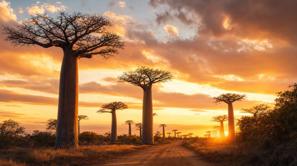
🌅 Morondava & the Avenue of the Baobabs
The west coast town of Morondava (population 65,000) is the gateway to the Avenue of the Baobabs and the limestone tsingy of Bemaraha. The Avenue itself is a 260-metre stretch of the unpaved RN8 about 20 km north of the town, where between 20 and 25 Adansonia grandidieri baobabs — endemic to Madagascar’s west and some over 800 years old, 30 metres tall, and 6 metres in trunk diameter — line both sides of the road. The trees were left standing when the surrounding forest was cleared for rice paddies in the early 20th century, leaving the picture-postcard alignment that’s now a protected landscape.
The Avenue is at its photographic peak in the hour before sunset. Most photographers shoot from the elevated viewpoint on the eastern verge — the trees silhouette against the falling sun. Morning is quieter and the light flatter; locals pass through with zebu carts at both ends of the day. The road is closed to vehicle traffic during peak sunset hours but pedestrians have free access. Dust haze in October–November deepens the orange tone significantly.
Beyond the Avenue, the unpaved road north to Bekopaka (the gateway to Tsingy de Bemaraha National Park) is a 200 km, 8–12 hour drive that includes two river ferry crossings (the Tsiribihina and the Manambolo) and is open only May to November. The reward is the only place on Earth where you can walk through a forest of 60-metre limestone needles, with Gondwanan endemics — leaf-tailed geckos, the Decken’s sifaka, the rare Madagascar fish eagle — clinging to the rock faces. Tsingy is a UNESCO World Heritage Site and the most logistically demanding park in Madagascar to reach.
- What to do: Sunset at the Avenue of the Baobabs; full-day Tsingy traverse via the via ferrata cables; pirogue trip on the Tsiribihina river; beach evening at Morondava’s Le Capricorne.
- Signature eats: Grilled fish at Chez Maggie or Renala in Morondava; mofo gasy (sweet rice-flour pancakes) from the morning street stalls.
- Access: Fly Tana–Morondava (1h 10m) or drive RN34 west (700 km, 2 long days, 4WD essential); Bekopaka 200 km north of Morondava on unpaved RN8, 4WD only, dry season only.
🐢 Nosy Be & the Northwest
The 312 km² volcanic island off the northwest coast and Madagascar’s beach-resort hub. Nosy Be (Malagasy for “big island”) sits at the same latitude as central Tanzania and gets the warmer Mozambique Channel current; the water is reliably 26–28°C year-round, visibility on the outer reefs hits 30 metres in the dry season, and whale shark season (October to early December) overlaps with the peak month for liveaboard diving. Andilana beach on the northwest tip is the postcard, but the smaller satellite islands — Nosy Komba (lemur reserve and the cleanest swimming), Nosy Iranja (a sandbar between two islets at low tide), Nosy Tanikely (a marine reserve with the best snorkelling) — are the genuine reason to be here.
The mainland gateway is Ankify, a 90-minute boat transfer from Hellville (the main town on Nosy Be). Direct international flights from Paris and Milan land at Fascene airport in season; otherwise, expect a domestic from Tana (1h 30m) with the standard schedule reliability caveats. The coastline north of Nosy Be — the Ampasindava peninsula, the Mitsio archipelago, the Radama islands — is among the least-developed in the western Indian Ocean and is reached only by liveaboard or chartered dhow.
- What to do: Snorkel Nosy Tanikely’s reef; ferry to Nosy Komba’s Black Lemur reserve; sandbar at low tide on Nosy Iranja; whale shark season Oct–Dec for the larger predictable encounters.
- Signature eats: Octopus carpaccio and rougail saucisses at Chez Loulou’a on Andilana beach; coconut-grilled langouste at the Hellville harbour stalls.
- Access: Tana–Nosy Be flight 1h 30m; or boat from Ankify (mainland) 90 min.
🌴 Masoala & the Far Northeast
The 2,400 km² peninsula and the largest single block of primary lowland rainforest in Madagascar. Masoala faces Antongil Bay on the northeast coast — the same bay where humpback whales calve in July to September — and is reached by speedboat from the small town of Maroantsetra. The peninsula has no roads. Visitors stay at one of three lodges along the coast and walk the rainforest with park guides; primary attractions are the red-ruffed lemur (endemic to Masoala), the aye-aye (the bizarre nocturnal lemur with the elongated middle finger), the helmet vanga, and the leaf-tailed Uroplatus geckos.
The logistical commitment is significant: Tana to Maroantsetra is a domestic flight (1h 45m, frequently cancelled), then 2-hour boat transfer in calm-water conditions only. Plan three minimum nights in Masoala plus 2-day buffers either side. The trade-off is solitude — Masoala receives roughly 800 visitors annually, against Andasibe’s 30,000+. This is the rainforest you choose if your trip is two weeks plus and you want one place that no one in your social network will have been to.
- What to do: Dawn rainforest walk for red-ruffed and white-fronted brown lemurs; humpback whale watching from the lodge boat (Jul–Sep); aye-aye night walk near the village of Tampolo.
- Signature eats: Crab vermicelli and fresh-caught dorade at the lodges; vanilla-everything (the Sambava–Antalaha region produces the bulk of the world’s vanilla and the supply chain is concentrated here).
- Access: Tana–Maroantsetra (1h 45m), then 2-hour speedboat to lodge.
“Ny adala no toa an’olona; ny hendry mahay miafina.” — The fool acts like a person; the wise know how to keep hidden. Wisdom, in the Malagasy register, is what doesn’t behave for show.
— Malagasy proverb, traditional
🗓️ Sample Itineraries
Madagascar rewards long trips and punishes rushed ones. Below are four templates that have worked for thousands of travellers. All assume late April through early November travel; cyclone-season variants require a full re-plan. Build a 2-day buffer at each end of every itinerary that uses domestic flights.
7 Days — Tana + Andasibe + Antsirabe
The shortest realistic introduction. Day 1: Arrive Ivato evening, transfer to Tana hotel. Day 2: Tana morning — Rova, Haute Ville walk, lunch at La Varangue. Drive RN2 east to Andasibe (4 hrs); night walk on the road verge for chameleons and mouse lemurs. Day 3: Dawn indri walk at Analamazoatra; afternoon Mantadia hike for diademed sifakas; second night walk. Day 4: Drive Andasibe back to Tana, then south on RN7 to Antsirabe (3 hrs from Tana). Pousse-pousse (rickshaw) tour of the colonial centre; thermal baths. Day 5: Day-trip to Lake Andraikiba and the artisan workshops on the Antsirabe ring road. Day 6: Return Tana via Ambatolampy (the aluminium-pot foundry village). Lemurs’ Park afternoon if not yet sated. Day 7: Buffer in Tana for souvenir shopping at Marché Pochard or Akany Avoko craft co-op; international departure evening.
12 Days — RN7 South to Tulear
The classic Madagascar overland. Day 1: Arrive Tana. Day 2: Tana to Andasibe overnight as above. Day 3: Indri morning, return to Tana, drive south to Antsirabe (3 hrs). Day 4: Antsirabe to Ambositra (the woodcarving capital, 1.5 hrs) and on to Ranomafana (5 hrs total). Day 5: Ranomafana morning rainforest walk; afternoon hot springs. Day 6: Drive Ranomafana to Fianarantsoa (1.5 hrs) and on to Ambalavao (1 hr); afternoon visit to the Antaimoro paper workshop and the village zebu market. Day 7: Anja Community Reserve for ringtail lemur troops (2 hrs) before continuing to Ranohira/Isalo (3 hrs). Day 8: Isalo Piscine Naturelle full day. Day 9: Drive Isalo to Tulear (4 hrs) via Ilakaka sapphire town; afternoon at Reniala spiny forest. Day 10: Ifaty/Mangily beach day or boat trip to the outer reef. Day 11: Fly Tulear to Tana (1h 15m). Buffer afternoon. Day 12: International departure.
14 Days — West Coast (Avenue of the Baobabs + Tsingy + Mahajanga)
For travellers chasing the country’s most photographed landscapes. Logistically demanding — most segments are unpaved, all require 4WD with a driver-guide, and Tsingy access is dry-season only. Day 1: Arrive Tana. Day 2: Andasibe overnight. Day 3: Return to Tana, fly Morondava (1h 10m). Day 4: Avenue of the Baobabs sunset shoot. Day 5: Drive RN8 north to Belo-sur-Tsiribihina (8 hrs including ferry, 4WD only). Day 6: Continue to Bekopaka and Tsingy de Bemaraha (4 hrs). Day 7: Tsingy Grand circuit with via-ferrata cables (full day). Day 8: Tsingy Petit circuit + Manambolo gorge pirogue. Day 9: Drive back south to Morondava (12 hrs in two days; sleep at Belo). Day 10: Morondava beach and Avenue second sunset attempt. Day 11: Fly Morondava to Mahajanga (regional, weather-dependent) or back to Tana. Day 12: Mahajanga Cirque Rouge and the baobab boulevard along the corniche, or Tana cultural day. Day 13: Return Tana, buffer. Day 14: International departure.
21 Days — Full Circuit Including Masoala
The serious traveller’s Madagascar. Combines the RN7 spine with the western circuit and a Masoala extension. Take the 12-day RN7 template above as the spine, then insert: Days 13–16: Fly Tulear back to Tana, then on to Maroantsetra (1h 45m). Speedboat to Masoala lodge. Three nights of rainforest walks, humpback whale boat (in season), aye-aye night search. Days 17–18: Return Tana via Maroantsetra; buffer day for cancelled flights. Days 19–20: Fly Tana to Nosy Be for two days of beach/snorkel decompression on Nosy Komba and Nosy Tanikely. Day 21: Return Tana, international departure. The 21-day version is the only one that genuinely shows you the country.
🎯 Strategy
If you have one trip and 14 days, do not try to combine RN7 with Tsingy in the same itinerary — pick one or the other. RN7 is the cultural and lemur-density spine; the West Coast / Tsingy is the photogenic singular destination. The travellers who try to do both in 14 days end up doing neither well; both are 10-day commitments minimum. The 21-day full circuit is the only structure that fits both with breathing room.
Malagasy Culture & Etiquette
Malagasy culture runs on a quietly stratified social code that takes most foreigners a full week to read correctly. Greetings are extensive — “Manao ahoana” (hello), followed by inquiries about family, work and the day, before transactional content begins — and rushing into business without the preamble reads as rude. Hierarchy by age is absolute; the eldest in any group is greeted first, served first, and consulted on any decision. The country runs on a polite egalitarian assumption between visitors and locals (no honorifics, no class signalling between strangers) that masks a more intricate kinship and ancestor-deference system underneath.
The single most distinctive cultural concept is fady — the system of taboos that varies village by village and clan by clan. Some are universal (do not point at a tomb with a straight finger; use the curled knuckle); others are hyper-local (in some Sakalava villages, pork is fady on certain days; in others, pregnant women must not enter a specific clearing). Your driver-guide will know the fady relevant to each region; ask before photographing tombs, sacred trees, or burial grounds. Violating a fady is rarely treated as a serious offence by hosts but always reads as a sign that the visitor didn’t bother to ask.
Famadihana — the “turning of the bones” ceremony in the highlands — is the most-discussed Malagasy ritual. Every five to seven years, Merina and Betsileo families exhume their deceased relatives from the family tomb, rewrap them in fresh silk lamba shrouds, dance with them around the tomb, and reinter them. The ceremony is a celebration, with music, food and a financial commitment that can run a full year’s family income. It typically happens between June and September. Witnessing one as a tourist is possible only by genuine invitation; do not show up uninvited.
💬 The Saying
“Ny fihavanana no mamorona ny aina.” Roughly: “It is the kinship-bond that creates life.” Fihavanana is the highland Malagasy word for the web of relational obligation — between family members, neighbours, and even strangers — that holds Malagasy society together. The concept has no clean English equivalent. Travellers who notice it (the unhurried inquiry into your family, the offer of food before any transaction) and respond in kind will find Madagascar opens up much faster than it does for travellers who don’t.
A Food Lover’s Guide to Madagascar
Malagasy food is the unsung cuisine of the western Indian Ocean — a fusion of Austronesian rice culture, East African meat traditions, French colonial technique and Indian Ocean spice trade that produces dishes you will not have eaten anywhere else. Rice is eaten three times a day and is to Malagasy food what bread is to French food; “vary” (rice) and “laoka” (the accompaniment) are the universal grammar of a meal.
Romazava is the de facto national dish — a clear-broth stew of zebu beef simmered with anamamy (mustard greens), ginger and tomato, served over a generous heap of rice. The version eaten in Tana is mild and broth-forward; the southern variant adds chili and is heartier. Every roadside hotely (small eatery) on RN7 serves it for MGA 8,000–15,000 ($1.80–3.30).
Ravitoto — pounded cassava leaves slow-cooked with pork — is the highland comfort dish, deeply green and oily, served with rice and a side of chili paste (sakay). Vegetarian versions exist but the porky original is the standard; the dish appears at every Sunday family meal in the highlands.
Achard — the pickled-vegetable condiment — is the obvious Indian Ocean borrowing, common across coastal Malagasy cuisine. Mango, papaya and chili-vinegar achards accompany grilled fish at every coastal market. The southwest dish akoho sy voanio (chicken simmered in coconut milk with ginger and turmeric) is the closest Malagasy analogue to a Mauritian curry and is the standard hotel restaurant offering in Tulear and Morondava.
Mofo gasy — sweet rice-flour pancakes cooked in cast-iron griddle wells, eaten hot from the morning street stalls — is the universal breakfast. A pile of eight pancakes plus sweet milk coffee runs MGA 3,000 ($0.70) and is the cheapest decent breakfast in the country. The savoury variant mofo baolina (fried dough balls with chili) is the lunch street-snack equivalent.
Vanilla deserves its own paragraph. Madagascar produces roughly 80% of the world’s vanilla — the bourbon-vanilla supply chain runs almost entirely through the Sambava–Antalaha–Andapa triangle in the northeast, and you will see vanilla pods drying on tarpaulins outside every house in the region. Vanilla price has fluctuated wildly (2017 peak above $600/kg wholesale; recent years closer to $80–120/kg) and the regional economy moves with it. Buy direct from a co-op if you can; pods cost a fraction of European retail.
Three Horses Beer (THB) is the de facto national lager, brewed in Antsirabe since 1958. The premium variant Pilsener is the standard; the dark Special and the Bonbon Anglais (a malted soft drink) round out the brewery’s range. Local rum (rhum arrangé) infused with vanilla, lychee, ginger or honey is the digestif, sold in bottle-or-glass at every coastal restaurant. The brand to look for is Dzama, distilled in Nosy Be since 1980.
📸 Photography Notes
Madagascar is the country where light timing is the difference between a postcard and a flat memento. The dry-season haze, the angle of the equatorial sun, and the dust at golden hour all conspire to produce strong directional light that’s softer than the equivalent in mainland Africa but sharper than anywhere else in the western Indian Ocean.
Best light by month: May–June for highland clarity (paddies still amber from harvest; cool air gives long views to 80 km from the Tana ridges). July–August for cool dry crisp light in the south and west — Tsingy textures separate beautifully under the hard overhead sun at midday. September–October for the haze-rich golden hour that makes the Avenue of the Baobabs sunset photographs glow. November for late-dry-season warmth before the rains. Avoid January through March entirely; the light is dull and the access is broken.
Four locations worth the detour:
- Avenue of the Baobabs at sunset — on the unpaved RN8 about 20 km north of Morondava (-20.2517°S, 44.4180°E). Shoot from the elevated eastern verge as the sun drops behind the western tree line. The 60–90 minutes before sunset is the prime window; arrive 90 minutes early to set up. Late October haze adds the deepest orange tones.
- Indri lemur calls in Andasibe at dawn (-18.9376°S, 48.4187°E) — not strictly a photographic location but the audio is the country’s most distinctive natural sound. The first dawn chorus typically starts at 5:45–6:15 a.m. depending on cloud cover. Pair with the standard Analamazoatra walk that begins at 7 a.m.
- Tsingy de Bemaraha at midday — the limestone needles at Bekopaka (-19.1336°S, 44.7553°E) photograph best when the sun is directly overhead and lights the deep crevasses. Most landscape photographers shoot at golden hour; for Tsingy specifically, midday between 11 a.m. and 1 p.m. is when the texture separates. The via-ferrata sections of the Grand Tsingy circuit are the best vantage points.
- Nosy Be sunset reflections — Andilana beach on the northwest tip of Nosy Be (-13.2922°S, 48.2175°E) faces almost due west, and the shallow tide-flat in the hour before sunset produces near-perfect mirror reflections of the sky. Best between July and October when the cloud is patchy rather than overcast.
Drone rules: Madagascar requires drone registration with the civil aviation authority (ACM) and a permit from the Ministry of Defence for any commercial use; tourist hobby use is technically permitted but practically requires landing in Antananarivo with a written purpose statement and is widely confiscated at customs. National parks (Andasibe-Mantadia, Ranomafana, Tsingy de Bemaraha, Isalo, Masoala) all prohibit drone flight without specific written permission. Most travel photographers leave drones at home for Madagascar.
✨ Pro Tip — Wildlife Ethics
Lemurs at Andasibe and Ranomafana are habituated but never tame. Stay 5 metres back; never feed them; never use flash on nocturnal species (the eyeshine you photograph at night is the tapetum lucidum reflecting your beam, and repeated flashes induce stress). Indri specifically should never be approached during the dawn call — they’re territorial and the call requires undisturbed forest acoustics. Chameleons should never be picked up; the rotation between branches you see in some old guide videos is genuinely stressful for them. The IUCN guidance is to shoot from one body length away with a 100mm+ macro and respect the animal’s flight distance. Local guides will enforce all of this.
Off the Beaten Path — Madagascar Beyond RN7
RN7 and the western baobab belt account for roughly 75% of foreign visits and about 10% of the country’s accessible terrain. The remainder is harder to reach, less-instagrammed, and much closer to the Madagascar Malagasy travellers actually use.
🦅 Anjajavy & the Northwest Cliffs
The 7,000-hectare private reserve on the northwest coast, accessible only by chartered flight from Tana to a 1,200-metre grass strip. Anjajavy combines a tsingy-like limestone landscape, deciduous dry forest, mangrove inlets and 4 km of private beach, with habituated populations of Coquerel’s sifaka, white-fronted brown lemur and the rare crowned sifaka. The Relais & Châteaux lodge built here in 2001 was for years the only accommodation; the reserve receives roughly 600 guests annually and is one of the few places in Madagascar where you walk among lemurs without entering a public park. Expensive, remote, and quietly the best wildlife-and-beach combination on the island.
🦎 Berenty & the Spiny Forest
The 265-hectare private reserve in the deep south near Fort Dauphin, founded in 1936 by the de Heaulme family on a sisal estate. Berenty is the easiest and most reliable place in Madagascar to see ringtail lemurs, Verreaux’s sifakas (the famous “dancing” sideways-hopping lemurs), and the brown mouse lemur in the spiny-forest octopus tree habitat. The reserve also has the Mandrare river gallery forest, where the dawn chorus is the country’s most varied. Access is via Fort Dauphin (Tana flight 1h 45m) and a 4-hour drive west on RN13. Three nights minimum. Pair with a Fort Dauphin coastal day for the Saint-Luce reserve and the surf at Lokaro.
🌋 Ankarafantsika & the Northern Dry Forest
The 135,000-hectare national park between Tana and Mahajanga on RN4. Ankarafantsika protects the largest remaining dry deciduous forest in Madagascar and is the type locality for the Coquerel’s sifaka and the mongoose lemur. The park has a network of well-marked trails, a sacred lake (Lac Ravelobe) where Nile crocodiles are reliably visible from the boardwalk, and a rare opportunity to walk a Malagasy national park without crowds — annual visitor numbers are below 4,000. The drive from Tana is 8 hours; most travellers combine Ankarafantsika with a Mahajanga onward leg.
🏖️ Andavadoaka & the Vezo Coast
The Vezo fishing villages north of Tulear along the southwest coast. Andavadoaka is the gateway to the Mikea coastal forest and the Velondriake locally managed marine area — a 800 km² network of community-protected reefs that has become the most-cited artisanal fisheries case study in the western Indian Ocean. Snorkelling and diving are the draws; the village of Andavadoaka has half a dozen modest lodges and the Coco Beach restaurant serves the southwest’s best grilled octopus. Access is by 4WD only — 6 hours of unpaved track north from Tulear, or charter flight from Tulear to the airstrip 5 km from town.
🐦 Ankarana & the Tsingy of the North
The 18,225-hectare park near Antsiranana (Diego Suarez) at the country’s northern tip, protecting a smaller and more accessible tsingy karst formation than Bemaraha. Ankarana has a network of caves (some used as ancestral burial sites, off-limits without local permission), underground rivers, and a population of crowned lemurs and Sanford’s brown lemur. The combination with the nearby Montagne d’Ambre rainforest park and the Emerald Sea sailing day from Diego Suarez makes the far north a viable 7–10-day extension for travellers who want a contrast to the RN7 spine.
Madagascar by Numbers
- 30 million — population (2025 estimate)
- 587,041 km² — total area (4th largest island on Earth)
- 107 — known lemur species, all endemic
- ~90% — proportion of wildlife found nowhere else
- 6 of 9 — world’s baobab species native to Madagascar
- ~80% — share of global vanilla supply
Practical Information
Currency: Malagasy ariary (MGA). Cash is essential outside Tana and the major hotels — credit cards are accepted at the upper-end Tana hotels, the better Nosy Be resorts, and a handful of Antananarivo restaurants, but assume cash everywhere else. ATMs in Tana, Antsirabe, Fianarantsoa, Tulear, Morondava and Nosy Be dispense ariary against international Visa cards; Mastercard is patchier. The single largest note is MGA 20,000 (roughly $4.50), so a meaningful cash withdrawal is a fat envelope. USD and EUR are exchangeable at any bank but rates outside the capital are poor.
Visa & entry: Visa-on-arrival for most nationalities (US, UK, Canada, Australia, NZ, EU): $35 for 30 days, $50 for 60 days, $55 for 90 days, payable in cash USD or EUR. The e-Visa form (evisamada.gov.mg) speeds the queue but does not waive the cash payment. Yellow fever certificate required if arriving from a yellow fever country. Malaria prophylaxis is medically advised for the entire country except above 2,000 metres — Atovaquone-proguanil (Malarone) is the standard; consult your travel medicine clinic 4–6 weeks before departure.
Language: Malagasy is the everyday spoken language; French is the language of administration, hotels, and most printed materials. English is spoken at major international hotels and by professional guides but cannot be assumed. A few French phrases (“bonjour,” “s’il vous plaît,” “merci”) and the universal Malagasy greeting “Manao ahoana” / response “Tsara fa misaotra” go a long way.
Connectivity: 4G covers Tana, Antsirabe, Fianarantsoa, Tulear, Morondava, Nosy Be and most regional capitals. Coverage drops to 3G or nothing in rural areas, the parks, and most of the south. Telma and Orange are the major networks; a local SIM costs MGA 5,000 with 10 GB of data for MGA 25,000 ($5.50). eSIM availability is limited; physical SIM is the safer choice. Hotel Wi-Fi exists but bandwidth is modest outside the major Tana and Nosy Be properties.
Tap water: Not safe to drink. Bottled water (MGA 2,500 / $0.55 for 1.5L) is universal; refill from sealed sources only. Ice in upper-end hotels is generally made from filtered water; ice in roadside hotelys is not. Bring a SteriPEN or LifeStraw for backup if you’re going remote.
Plug type: Type C and E (European, two round pins, 220V/50Hz). North American and UK travellers need adapters. Power is unreliable in remote areas; expect generator-only at most rainforest lodges between 6 p.m. and 10 p.m. only.
Budget Breakdown — What Madagascar Actually Costs
Madagascar is paradoxically inexpensive on the ground but expensive to access. Domestic flights, 4WD with driver, and park entry fees compound to roughly $150–280 per person per day for a mid-range trip; food and beer outside hotels are dirt-cheap (a beer is $1, a meal $3–5 at any roadside hotely). Most first-time visitors significantly underestimate the transport line item and overestimate the food line.
💚 Budget Traveller — $60–110 / day
Guesthouses (chambres d’hôte) at MGA 60,000–100,000 ($13–22) per double; hotely meals at MGA 8,000–15,000 ($2–3). Public transport — taxi-brousse (the shared minibus network) — is available on most paved routes at very low prices but costs you full days of travel time. Park fees range MGA 65,000–75,000 ($14–17) plus mandatory guide MGA 30,000–60,000 ($7–13). Achievable for a backpacker willing to skip the western circuit and spend 10 days on RN7.
💙 Mid-Range — $180–280 / day
3-star hotel or lodge double MGA 350,000–650,000 ($75–140); restaurant dinner with one drink MGA 70,000–120,000 ($15–27); 4WD with driver-guide $100–140/day all-in. Domestic flights $150–280 one-way depending on route. One major activity per day (park guide MGA 60,000, half-day boat MGA 200,000–400,000). This is the realistic shoulder-season cost for a couple on the standard RN7 itinerary.
💜 Luxury — $550+ / day
Madagascar’s high-end is a small but distinctive set — Anjajavy (Relais & Châteaux), Constance Tsarabanjina on the Mitsio archipelago, Time + Tide Miavana on Nosy Ankao — runs $900–2,400 per person per night all-inclusive of charter flights, guides, and dining. Tana’s high-end hotel scene is modest by global standards (Carlton, Pavillon de l’Emyrne); the country’s true luxury infrastructure is concentrated on the offshore private islands and the Anjajavy reserve. Helicopter transfers between sites are the upper-end logistical solution.
| Item | Budget (MGA) | Mid-range (MGA) | Luxury (USD) |
|---|---|---|---|
| Bed (per night) | 60,000–100,000 | 350,000–650,000 | $900–2,400+ |
| Dinner | 8,000–15,000 (hotely) | 70,000–120,000 | All-inclusive |
| Daily transport | 30,000 (taxi-brousse) | $100–140 (4WD + driver) | Charter flight |
| One park visit | 95,000–135,000 | 95,000–135,000 | Included |
| USD daily | $60–110 | $180–280 | $550+ |
🧳 Travel Guru Tip — The Driver-Guide Economy
The single highest-value spend on a Madagascar trip is hiring a Malagasy driver-guide for the overland sections, ideally booked through a Tana-based local operator rather than an international agency. The local rate is roughly $80–120/day all-in (vehicle, fuel, driver, his lodging and meals); the international agency rate for the same arrangement is typically 2–3x. The driver-guide is the country’s single most underrated cultural conduit — they speak Malagasy and French, know the regional fady, can negotiate police checkpoints painlessly, and turn the long RN7 drive into a moving cultural class. Tip MGA 50,000–100,000 ($11–22) per day at the end as the local convention.
✅ Pre-Trip Checklist
The minimum kit and admin to have sorted before you fly. Madagascar punishes underprepared travellers harder than its reputation suggests — medical, transport and currency planning all require more advance work than a typical East African circuit.
- Documents: Passport valid 6 months past return date with at least 2 blank pages. Visa-on-arrival cash in USD or EUR ($35 for 30 days). Yellow fever certificate if arriving from a yellow fever country. Print all bookings; offline copies on phone.
- Vaccinations: Confirm routine + Hepatitis A and B, typhoid, rabies (recommended for rural travel), and yellow fever (if applicable). Consult a travel medicine clinic 4–6 weeks ahead.
- Malaria prophylaxis: Medically advised below 2,000 metres. Atovaquone-proguanil (Malarone) is the standard regimen; doxycycline and mefloquine are alternatives. Start 1–2 days before, continue 7 days after departure (Malarone) or 4 weeks (other regimens).
- Insurance: Travel insurance with cover for medical evacuation up to $1m, adventure activities (rainforest hikes, diving, tsingy via-ferrata), and trip cancellation. World Nomads, SafetyWing and IMG Patriot are standard. Madagascar’s medical evacuation typically routes via Réunion or Johannesburg.
- Cash: USD and EUR cash for visa-on-arrival and back-up exchange. ATMs in major towns dispense ariary on Visa; Mastercard works less reliably. Plan to carry 2–3 days of cash at all times.
- Layers: Lightweight breathable hiking clothes for the rainforest parks; warm fleece for the highland evenings (Tana, Antsirabe, Ranomafana evenings drop below 12°C in May–August). Waterproof shell jacket regardless of season.
- Footwear: Waterproof hiking boots with proper ankle support (mandatory for tsingy via-ferrata). Sandals for beach and town.
- Headlamp: Mandatory for night walks in Andasibe and Ranomafana, and for power outages at remote lodges.
- Medical kit: Antimalarials, oral rehydration salts, antibiotic for traveller’s diarrhoea (azithromycin standard), antihistamines, sunscreen SPF 50, DEET 30%+, blister kit.
- Apps to download: Maps.me with offline Madagascar package; XE Currency; offline French and Malagasy phrasebook; iNaturalist for lemur and chameleon species ID.
- Camera kit: 70–300mm lens for lemurs (200mm minimum); 100mm macro for chameleons and frogs; wide angle for landscapes and tsingy.
🤔 What Surprises First-Timers
- It feels like Indonesia, not Africa. The Austronesian heritage — terraced rice paddies, the language, the food, the staircase houses — produces a country that visually and culturally bears a stronger family resemblance to Borneo and Sulawesi than to Mozambique 400 km away. First-time travellers from East Africa are routinely thrown by this.
- The roads are slower than the map suggests. A 300 km drive on RN7 takes 7–9 hours, not 4. Add zebu carts, market days, police checkpoints, and the routine pothole density, and the practical average speed is 35–45 km/h. Plan accordingly.
- Lemurs are everywhere — and never the same species twice. Each park has its own lemur cast — indri at Andasibe, Milne-Edwards’ sifaka at Ranomafana, ringtails at Anja and Berenty, Coquerel’s sifaka at Anjajavy. Travellers who think “I saw lemurs at Andasibe” and skip the others miss the radiation that’s the entire point.
- Vanilla is everywhere and is much cheaper at source. A vanilla pod that retails in a European specialty shop for €5 costs MGA 1,500–2,500 ($0.30–0.55) at a Sambava co-op. Buy a kilo. It keeps for 2 years and is the country’s most useful souvenir.
- Domestic flights are not on time. Madagascar Airlines / Tsaradia operates an admirably extensive network with admirably unreliable schedules. Two-hour delays are typical; cancellations to two or three days later happen weekly. Build the buffer.
- French goes much further than English. Even basic French opens doors that English does not. The country was a French colony for 64 years and Francophone is the default register for any educated Malagasy.
- The country does not run on tipping. Service charges are usually included; small tips at hotels and restaurants are appreciated but not mandatory. The exception is your driver-guide, who is genuinely tipped 10–15% of the agreed daily rate at trip end.
- You will see poverty. Madagascar is among the lowest-income countries in the world by GDP per capita; the average household income outside Tana is below $2/day. The contrast between the visitor experience and rural daily life is sharper than in most travel destinations and is worth thinking about before you book.
Frequently Asked Questions
Is Madagascar safe for tourists?
For most travellers, yes — but with awareness. Petty crime (pickpocketing, opportunistic snatching) is moderate in downtown Antananarivo and Tulear; violent crime against tourists is rare. Avoid downtown Tana after dark, do not display large cash or expensive electronics in markets, and use pre-arranged transport for night moves. Outside the cities the country is generally peaceful. Demonstrations in central Tana are intermittent and predictable — your driver-guide will route around them. Solo female travellers report Madagascar as broadly comfortable with sensible precautions; harassment levels are lower than in many neighbouring countries.
Do I need a 4WD?
Yes, for any overland travel south of Antananarivo on RN7 and for all unpaved branch routes (RN8 to Tsingy de Bemaraha, RN35 to the east coast, the southwest coastal track). Self-driving is theoretically possible but practically discouraged — police checkpoints, language gaps, fuel scarcity in the south, and the occasional washout make a hired 4WD with a Malagasy driver-guide the realistic option for almost every first-time visitor.
Can I see lemurs without going to a remote park?
Yes — Andasibe is 4 hours from Tana on a paved road and has the highest indri density in the country. Lemurs’ Park (22 km from Tana) has nine free-ranging species in a 5-hectare reserve and is the de facto pre-departure stop. For the iconic ringtails specifically, Anja Community Reserve on RN7 (a 9-hour drive from Tana) and Berenty in the deep south are the best bets.
Is malaria prophylaxis really necessary?
Yes, below 2,000 metres elevation — which is most of the country, including Tana itself in some seasons. The Antananarivo plateau (1,280 m) is at moderate risk; the coastal regions and rainforest corridor are high-risk year-round. Atovaquone-proguanil (Malarone) is the standard regimen with the fewest side effects. Skip prophylaxis at your own risk; falciparum malaria is the dominant strain and is the medically dangerous one.
Is the tap water safe?
No. Drink bottled or purified water exclusively. Brush teeth with bottled water in rural areas; in Tana hotel taps, brushing is generally fine but drinking is not. Ice in upper-end hotels is filtered; ice elsewhere is not.
When can I see baby lemurs?
September to October is peak birthing season for ringtails, sifakas, and most diurnal species. Newborns cling to mother’s belly for the first 3–4 weeks, then ride dorsally through about 12 weeks. October is the photographic peak. Indri have a roughly 2-year inter-birth interval and infants can appear any month.
How long does a meaningful Madagascar trip take?
Two weeks minimum for the RN7 spine plus a coastal week. Three weeks if you want to add the western circuit (Avenue of the Baobabs, Tsingy) without rushing. Four weeks for the full circuit including Masoala. Trips of less than 10 days work only as a focused regional visit (Andasibe + Tana + a beach extension).
Can I visit during the cyclone season?
Technically yes, but most experienced operators do not recommend January through mid-March. Roads collapse, domestic flights cancel for days at a time, and access to the eastern parks is unpredictable. December and April are the cyclone-season shoulders that work for a focused highlands trip.
What’s the one thing first-timers regret skipping?
The night walks. The diurnal lemur viewing at Andasibe and Ranomafana is the headline draw, but the nocturnal species — mouse lemurs, woolly lemurs, leaf-tailed geckos, parson’s chameleons — are the genuinely unique-to-Madagascar fauna and are seen only on after-dark walks along the park access roads. Skip the night walks and you’ve seen half the wildlife.
Ready to Explore Madagascar?
Madagascar rewards travellers who plan a lot and improvise gracefully. The lemurs, the baobabs, the tsingy, the rainforests, the spiny-forest octopus trees — they will be there. The flights, the roads, and the cyclone calendar decide the order. Build the itinerary, then build the buffers.
For a tailored Madagascar trip — including 2026 cyclone-aware routing, RN7 logistics with a vetted driver-guide, or a Masoala extension — start with our trip-planning service. We’ll pair you with the right local operator and the right window.
Heading to the capital first? Our Antananarivo city guide covers arrival logistics, neighbourhoods, and the best day trips from Tana.
More country guides you might like
Plan your trip to Madagascar Travel Guide
The booking tools we use ourselves. FFU may earn a commission at no extra cost to you.