Namibia Travel Guide — 825,000 km² of Sand Sea, Skeleton Coast & Open Sky
I have driven to Sossusvlei four times now, and on every single approach the same scene re-arranges my brain: the gravel C19 lifts away from the Tsaris Mountains, the low sun catches the apricot crests of the Namib dunes, and a ribbon of springbok crosses the road as if to confirm we are nowhere near anywhere familiar. My favourite Namibia argument with travel friends is whether Etosha or Damaraland is the better second stop after the dunes — I always argue Damaraland, because nothing reorders my sense of geological time quite like a desert-adapted elephant ghosting past a 6,000-year-old rock engraving — and my second-favourite is whether the country’s signature dish is kapana from a Windhoek street brazier or the sundowner oryx fillet at a Skeleton Coast lodge. Treat this guide as the brief I would hand my own sister before she boarded her first flight into Hosea Kutako, with a 4×4 already booked and a head torch in her hand luggage.

In This Guide
- Overview — Why Namibia Belongs at the Top of Every Africa Bucket List
- From German South-West to Conservation Pioneer — A Pocket History
- Best Time to Visit Namibia (Season by Season)
- Etosha Game-Viewing Season 2026 — Waterhole Concentrations
- Getting There — Hosea Kutako (WDH) & Walvis Bay (WVB)
- Getting Around — Self-Drive Country, Westair & Gravel-Road Etiquette
- Top Cities & Regions — Sossusvlei, Etosha, Damaraland & the Skeleton Coast
- Cultures & Peoples — Himba, Herero, San, Damara, Nama, Owambo
- A Food Lover’s Guide to Namibia
- Off the Beaten Path — Spitzkoppe, Kaokoland & the Quiver Tree Forest
- Practical Information
- Budget Breakdown
- Planning Your First Trip to Namibia
- Frequently Asked Questions
Overview — Why Namibia Belongs at the Top of Every Africa Bucket List
Namibia is a wildly oversized republic on Africa’s south-western edge — 825,615 km² of mostly desert and savannah, stretched between Angola in the north and South Africa in the south, with a 1,572 km Atlantic coastline running down its western flank. Just over three million people live here as of 2025, making Namibia the second-least-densely-populated country on Earth after Mongolia, at roughly 3.7 residents per km². The capital, Windhoek, sits inland on the Khomas Highland plateau at about 1,700 m elevation and houses 486,169 people as of the 2023 census — almost one in six Namibians.
The first story of Namibia is age. The Namib Desert, which gives the country its name, is the oldest desert on the planet — some 55 million years of arid or semi-arid conditions, sustained by the cold Benguela current upwelling along the coast. Inside it, the Namib Sand Sea was inscribed as Namibia’s first natural UNESCO World Heritage property in 2013, covering 3,077,700 hectares of dune sea where individual dunes around Sossusvlei top 300 metres. A few hundred kilometres inland at Twyfelfontein, more than 2,500 rock engravings — giraffes, rhinos, ostriches, the famous “Lion Man” — were carved into red sandstone over roughly 6,000 years by hunter-gatherers and Khoekhoe herders, and inscribed as a cultural UNESCO site in 2007.
The second story is the layered colonial inheritance that still shapes the streets, the schnitzel and the surnames. The Germans declared a protectorate over “Deutsch-Südwestafrika” in 1884, prosecuted the genocide of the Herero and Nama between 1904 and 1908 — a crime Germany formally recognised as such in 2021 — and lost the territory to South African forces during World War I in 1915. South Africa administered Namibia under a League of Nations mandate, then unilaterally as a fifth province under apartheid, until a 23-year liberation war led by SWAPO ended with independence on 21 March 1990. Walvis Bay, the country’s only deep-water port, did not formally come under Namibian sovereignty until 1 March 1994.
The third story is conservation, and it is the one that should change how you think about a safari country. Namibia was the first country in the world to write environmental protection into its constitution: Article 95 commits the state to maintaining “ecosystems, essential ecological processes, and biological diversity.” Since 1996 a community-based system has allowed rural Namibians to register communal conservancies that share tourism and trophy-hunting revenue; by 2024 these conservancies plus formal national parks covered roughly half of all national land — about 192,000 km² of formally protected ecosystem. The result is the world’s largest free-roaming black-rhino population (Etosha and the Kunene), the world’s largest cheetah population (around 2,500 wild individuals, monitored from a research base 44 km east of Otjiwarongo by the Cheetah Conservation Fund), and a Caprivi corridor that lets African elephants move between five countries. The Cheetah Conservation Fund’s own field reports, Save the Rhino’s annual updates, the WWF African programme, the IUCN Red List, the Convention on Biological Diversity Namibia profile, and the Namibian Association of Community-Based Natural Resource Management Support Organisations (NACSO) document the population recoveries in detail.
The fourth story is light and silence. Namibia averages more than 300 sunny days a year, the coastline gets less than 50 mm of rainfall annually under the Benguela fog, and the sparsely lit interior was the first country in Africa to declare a “Dark Sky Reserve” — the NamibRand Reserve south of Sesriem holds International Dark Sky Association Gold Tier status. Tourism reflects all of this: a record 1,257,093 international arrivals in 2024 (a 45.5% jump on 2023), driven mainly by South Africans (38.5% of the total) and overseas markets led by Germany, the United States and Britain. Tourism revenue topped USD $435 million the same year, the equivalent of roughly USD $343 per visitor. Independent reporting from Reuters, the BBC, the Guardian, the New York Times and the Financial Times tracks the recovery curve in detail.
Practically, Namibia in 2026 is the most legible safari country in Africa for first-timers. English is the sole official language; everyone working in tourism speaks it cleanly, with Afrikaans as the second tongue and German still widely heard along the coast. Driving is on the left, plugs are South-African Type D and M at 220V, the currency is the Namibian Dollar pegged 1:1 to the South African rand (and the rand is itself legal tender), and the road network — about 6,400 km of asphalt plus 42,000 km of gravel — connects every flagship park without you ever needing a charter flight. Lonely Planet has called Namibia “Africa’s most photogenic country,” and the description is hard to argue with once you stand on top of Dune 45 at 06:42 in late June. National Geographic, Condé Nast Traveler, Travel + Leisure, AFAR, Bradt Guides, Rough Guides and Fodor’s all maintain dedicated Namibia desks with current 2026 itinerary recommendations. Pack a head torch, a microfibre travel towel and at least one neutral-coloured fleece — the Sossusvlei pre-dawn is genuinely cold even in November.

From German South-West to Conservation Pioneer — A Pocket History of Namibia
Namibia’s prehistory begins where everyone’s does — with the San, the world’s oldest continuous hunter-gatherer culture, whose ancestors painted and engraved across the Brandberg, the Erongo and Twyfelfontein for at least the last 6,000 years. The “White Lady” rock painting on the Brandberg massif (Tsisab Gorge) is now dated to between 2,000 and 4,000 years ago, painted by Khoisan hunter-gatherers and not, despite a once-popular myth, by ancient Mediterranean visitors. Bantu-speaking Owambo, Herero and Damara migrated south in the late first millennium AD, the Nama moved up from the Cape from the early 1800s, and the country we now think of as Namibia was a complex multi-ethnic patchwork long before the first European missionary arrived.
The colonial sequence is short, brutal and unusually well documented. Portuguese explorer Diogo Cão erected a stone padrão at Cape Cross in 1486 — it still survives in a Berlin museum — but the Portuguese never colonised the coast because there was no fresh water and no obvious commodity. Britain annexed only Walvis Bay (1878) and let Otto von Bismarck claim the rest as German South-West Africa from 1884. The first decade of German rule built the railway and the colonial-Lutheran churches; the second decade brought the systematic extermination of the Herero and Nama between 1904 and 1908 in what historians now classify as the twentieth century’s first genocide. Germany’s federal government formally recognised the events as genocide in May 2021 and pledged €1.1 billion in development aid — a settlement Herero and Nama representative groups continue to contest.
South African forces under Louis Botha invaded in July 1915, accepted the German surrender at Khorab in three weeks, and South Africa administered the territory under a 1920 League of Nations Class C mandate. When the League dissolved in 1946, South Africa refused to convert the mandate to a UN Trust Territory and instead extended apartheid’s racial-classification laws into Namibia — a unilateral move the International Court of Justice declared illegal in 1971. The South West Africa People’s Organisation (SWAPO), founded in 1960, fought a 23-year liberation war from bases in Angola and Zambia. United Nations Security Council Resolution 435 framed the eventual ceasefire and election supervision; UN-monitored elections in November 1989 gave SWAPO a 57% majority, and Namibia became Africa’s 32nd independent state on 21 March 1990 with Sam Nujoma as its first president.
The post-1990 story is the most encouraging part of the timeline, and it explains why Namibia is now the African country every conservation graduate student writes about. The 1996 Nature Conservation Amendment Act gave communal-area residents the legal right to register conservancies and capture the revenue from wildlife on their land — flipping the colonial assumption that the state owned the game. By the early 2000s elephant numbers in the Kunene had climbed from 50 to 500, plains-zebra numbers from 500 to 14,000, and the country was hosting the world’s largest free-roaming black-rhino and cheetah populations. Namibia held its sixth democratic election in November 2024, returning Netumbo Nandi-Ndaitwah as the country’s first female president and SWAPO’s continued majority.
For a deeper-dive history and geology framing, the British Museum’s Africa collection page, the Smithsonian Magazine archive, JSTOR’s open-access African studies portal, the South African History Online project, the National Museums of Namibia, the Goethe-Institut Windhoek and the Deutsche Welle Africa desk all maintain authoritative material that is updated more often than a printed Bradt edition. The European Space Agency’s Sentinel-2 Earth-observation imagery and NASA’s Earth Observatory offer satellite views of the Namib Sand Sea that quantify the dune migrations the UNESCO inscription describes.
Two practical hangovers from this history are worth flagging before you arrive. The first is colonial architecture: Lüderitz, Swakopmund and central Windhoek still wear their Wilhelmine façades like a film set, and the Christ Church (Christuskirche), the Tintenpalast Parliament building and Heinitzburg Castle in Windhoek read as Bavaria-on-the-savannah even today. The second is language: English replaced Afrikaans as the sole official language at independence, deliberately, to give no single domestic group a linguistic advantage — but Afrikaans is still the lingua franca on the road, German is heard in Swakopmund coffee shops, and Oshiwambo dominates the north. A traveller who can manage “dankie” (thanks, Afrikaans) and “tjiri-pó” (yes, Otjiherero) will get further than one who cannot.
Best Time to Visit Namibia (Season by Season)
Namibia has the most legible weather pattern in southern Africa: a long, cool, almost-rainless dry season from May to October and a hotter “emerald” rainy season from November to April. Daytime temperatures vary by altitude (Windhoek’s 1,700-metre plateau is much cooler than the Kalahari floor), the coast is fog-cooled to a near-constant 15–20 °C year-round, and the interior gets enormous diurnal swings of up to 30 °C. Plan around the season, not the calendar — a June desert morning at Sossusvlei and a December afternoon at Etosha are basically two different countries.
Cool-Dry Winter (May–August) — Peak Game-Viewing Season
This is the postcard window. Daytime highs sit at 22–25 °C in the interior, dropping to 5 °C or below at night in the deserts (and occasionally to freezing on Sossusvlei’s gravel plains in July). Vegetation is bone-dry, dust hangs over the gravel roads, and animals concentrate around the few remaining waterholes — Etosha’s Okaukuejo, Halali and Namutoni floodlit pans become 24-hour wildlife theatres in July and August. Skies are typically cloudless, the Milky Way is at its photogenic best, and the Sossusvlei dunes hold their long shadows from 06:30 to 09:00 and again from 16:30 to sunset. Pack layers: a fleece, a beanie and gloves for the pre-dawn dune climbs are not optional. Lodge prices peak from late June to early September, and flagship Etosha rest-camp sites should be booked 6–9 months ahead.
Shoulder Spring (September–October) — Best Overall Compromise
The single best window for first-time visitors. Daytime temperatures climb back to 28–32 °C in the interior, the cool nights soften, and Etosha’s wildlife concentrations become almost ridiculous as the last seasonal pans dry up. The first rains have not yet arrived, gravel roads remain crisp, and the desert sky stays cloudless. The Fish River Canyon hiking-trail permit window closes on 15 September because the heat past that date becomes genuinely dangerous (45 °C+ in the canyon floor), so book the trek for the first half of the month if it’s on your list. By late October the heat in the desert south can hit 40 °C, but cool coastal evenings around Swakopmund are still 18 °C — perfect for a walking-around-with-camera holiday.
Hot-Wet Summer (November–February) — Emerald Season
The “Little Rains” arrive in November and the main convective storms run from January to March. Daytime temperatures reach 35–40 °C in the desert lowlands, lightning storms are spectacular, and the interior turns suddenly green. Etosha’s mammal-watching is harder because game disperses to ephemeral pans, but birding is sensational with more than 340 species recorded in the park alone — Palaearctic migrants pile in from late November. Sossusvlei is at its most photogenic in early-summer thunderstorm light, and you’ll have the dunes near to yourself. The trade-off is gravel-road damage after heavy rain, malaria risk in the Caprivi/Zambezi and Kavango regions, and lodge closures or reduced service in some remote areas.
Late-Wet Autumn (March–April) — Green & Quiet
The most underrated stretch on the calendar. Rain tapers, daytime highs drop back to 28 °C, the green plains haven’t yet faded, calving season for springbok and oryx peaks, and lodge prices sit roughly 25–35% below peak winter rates. The ephemeral Hoanib River in Damaraland may briefly flow, and the Etosha Pan often holds water — if so, the southern shoreline draws thousands of greater and lesser flamingos, a spectacle most safari brochures never mention. Birdlife stays excellent because the migrants haven’t yet left. The downside is that game-viewing requires more patience (animals are still dispersed), some 4×4 tracks remain muddy, and a handful of rest camps run reduced services until early May.

Etosha Game-Viewing Season 2026 — Waterhole Concentrations from August to October
If you can pick only one window in 2026, pick the back end of the dry season — roughly 1 August to 31 October — and aim it squarely at Etosha. By August every ephemeral pan in the park’s 22,270 km² has dried up, and the only standing water left across an area larger than Israel is the handful of contact-springs and pumped boreholes at Okaukuejo, Halali, Namutoni, Kalkheuwel, Klein Namutoni and Goas. The animals know exactly where these are, and they queue. By mid-September it is normal to sit at the floodlit Okaukuejo waterhole between 19:00 and 22:00 and watch black rhino, elephant, lion, hyena and giraffe drink, in that order, without leaving your camp chair.
The numbers behind the spectacle are extraordinary. Etosha hosts roughly 114 mammal species, 340 bird species and 110 reptile species; the park is “the single most important custodian of the black rhino in the world,” holding around a third of the global free-roaming population. Lion density is high in the Okaukuejo–Halali area, the Etosha elephant population was estimated at around 2,500 in the most recent census, and you have a realistic chance of spotting all of the “Little Five” (oryx, eland, springbok, hartebeest, blue wildebeest) on a single self-drive day in this window. The light is hard but the dust haze gives a peculiar pastel quality after 16:00 that no amount of golden-hour Tuscany prepares you for.
Namibia’s 2024 numbers explain why the late-dry window is filling up faster than ever: international arrivals jumped 45.5% to 1,257,093, with South Africa supplying 38.5% of all visitors and Germany leading the overseas markets, followed by the United States and Britain. The European school-summer-holidays peak (mid-July to late August) and the school holidays of South Africa (late September to early October) overlap inside this seasonal hook — and Etosha’s three big rest camps (Okaukuejo, Halali, Namutoni) plus the four flagship private camps (Onguma, Mushara, Ongava, Etosha Heights) routinely sell out 6–9 months ahead for these dates.
The practical play for 2026 is to anchor four nights inside the park (two at Okaukuejo for the floodlit waterhole, one at Halali for Moringa Springs at night, one at Namutoni for the eastern Andoni Plain), then extend a single night south at Onguma or east at Mushara to break the 850 km drive back to Windhoek. Booking opens 11 months in advance through Namibia Wildlife Resorts; flagship private camps usually take direct bookings 12 months out. Skip mid-September if you can — Namibia’s main public holiday clusters (Heroes’ Day, 26 August) and South African mid-spring breaks compress demand into a brutal three-week window.

Getting There — Hosea Kutako International & the Coastal Alternative
Almost every visitor enters Namibia through Hosea Kutako International Airport (IATA: WDH), 45 km east of Windhoek on the B6 highway and named since 1990 after the Herero chief who petitioned the United Nations against South African annexation in the 1940s. The airport handled 1,257,093 passengers in 2024, which conveniently mirrors the country’s tourist-arrival figure for the same year, and is operated by the Namibia Airports Company as a Category 9 facility with two runways and roughly 315 weekly scheduled movements. A third terminal is currently under construction to absorb the post-2024 surge.
Long-haul access is short and predictable. The two daily Frankfurt rotations (Discover Airlines) and a parallel Discover Munich service connect Namibia to the Lufthansa Group network — Frankfurt is the historical European gateway and remains the cheapest cash-flight path from London, Paris, Madrid or Amsterdam in 2026. Ethiopian Airlines flies daily from Addis Ababa, providing onward links to North America via JFK, IAD and YYZ; Qatar Airways resumed direct Doha service in 2023, opening a fast Asian and Middle Eastern routing; and African connections come through Johannesburg (Airlink, South African Airways), Cape Town (Airlink, FlyNamibia) and Victoria Falls (FlyNamibia). US travellers should price both the JNB connection (one-stop, KLM-or-Delta + SAA) and the Doha or Addis routings — the difference is rarely more than USD $200 and the Doha option saves a full transit day in each direction.
Walvis Bay International (IATA: WVB), about 1,200 m from the Atlantic and 35 km from Swakopmund, is the country’s secondary international gateway. Eurowings has flown a seasonal Cologne–Frankfurt–WVB rotation since 2014; Airlink and Westair add daily Cape Town and Windhoek hops. Flying directly into WVB and out of WDH (or the reverse) saves 700 km of self-drive backtrack on a classic Sossusvlei–Etosha loop and is genuinely worth the open-jaw fare premium, especially for a 10–14 day itinerary.
Land borders are extensive and increasingly traveller-friendly: the busiest is Noordoewer/Vioolsdrif (24-hour, the main South Africa road from Cape Town), with Ariamsvlei (24-hour), Mata-Mata (Kgalagadi, daylight), Ngoma (Botswana to the Caprivi/Zambezi, daylight) and Wenela (Zambia, daylight) seeing regular tourist traffic. Cape Town to Windhoek by road is around 1,500 km on tarmac via Springbok, comfortably done in two long days. The TransNamib passenger train service is currently freight-only after 2020, so don’t budget on rail.
Visa policy changed materially on 1 April 2025: 33 nationalities — including the United States, United Kingdom, all EU member states, Canada, Australia and New Zealand — lost the visa-free regime they had enjoyed since 1999, on the stated grounds of reciprocity. The fix is straightforward: an e-visa applied for online seven days before flight, a visa-on-arrival counter at Hosea Kutako that costs about USD $88 and accepts card payment, and a 90-day single-entry stamp on a passport with at least six months of validity. African Union member-state citizens still pay only USD $66 (or the Namibian-dollar equivalent) on arrival.
Getting Around — Self-Drive Country, Westair & Gravel-Road Etiquette
Namibia is the rare African country where the default tourism mode is self-drive, and where the road infrastructure rewards it. The total network runs to roughly 6,400 km of asphalt B-roads and 42,000 km of graded gravel C- and D-roads, all maintained by the Roads Authority of Namibia and signposted to a German-engineered standard the rest of the region rarely matches. Driving is on the left (a holdover of South African colonial administration), the rural speed limit on tarmac is 120 km/h and on gravel 80 km/h — and the gravel limit, unlike the tarmac one, is widely enforced because it tracks tyre survival rather than authority enthusiasm.
The vehicle of choice for most international visitors is a high-clearance double-cab 4×4 with a roof tent, two spare wheels and a long-range fuel tank — booked from established operators such as Asco, Bushlore, Britz Namibia, Caprivi Car Hire, Discover Namibia, Avis 4×4 or SafariCar. Daily 2026 rates start around USD $115 for a single-cab Hilux and climb to USD $350+ for a fully kitted Land Cruiser 79 with refrigerator, water tanks and rooftop tent. A standard 2WD sedan can cover Sossusvlei, Etosha and Damaraland on tarmac and well-graded C-roads, but it cannot reach Sandwich Harbour, the Hoanib Skeleton Coast or the deep Kaokoland — and most rental contracts explicitly exclude D-roads in those areas for sedan classes. The economics work out: a small 4×4 with a rooftop tent halves your nightly accommodation cost across a 14-day loop and pays for itself by night six.
Scheduled and charter flying fills the gaps the road network can’t, particularly into the deep Kaokoland and the Hoanib River valley. Westair Aviation (under the FlyNamibia brand) operates daily Cessna Caravan rotations from Windhoek Eros (ERS) to Sossusvlei, Damaraland, Skeleton Coast Camp, Hoanib, Doro Nawas and Etosha Heights — the standard “fly safari” sequence is a two-or-three-camp circuit with strict 20 kg soft-bag luggage allowances. Charters from Eros for two or four passengers price out at USD $1,400–2,200 per leg in 2026 and become economical for groups of three or more. Eros Airport sits 5 km south of central Windhoek and handles all light-aircraft traffic — never confuse it with Hosea Kutako 45 km east.
Ground public transport is sparse. Intercape long-haul coaches run Windhoek–Cape Town (via Keetmanshoop) and Windhoek–Victoria Falls (via Caprivi); kombi minibuses cover internal towns; and Bolt cabs run inside Windhoek, Swakopmund and Walvis Bay at NAD 8–12 per kilometre. For most travellers, the practical answer is “fly into WDH, pick up the 4×4 at Eros or the airport on day one, drop it back on day 10 or 14.”
Gravel-Road Etiquette & Survival
Gravel driving is the single most common cause of insurance claims, lodge late-arrivals and accidental rollovers in Namibia. Three rules cover most of it. First, drop tyre pressure to 1.8–2.0 bar before you leave the tarmac and re-inflate at the next fuel station — high pressure on washboard surfaces causes punctures and side-wall splits. Second, never travel above 80 km/h on gravel and slow to 40 km/h when oncoming vehicles approach (windscreens crack from flying chippings; replacements take days to source). Third, refuel whenever the gauge drops below half — the most exposed legs (Solitaire to Sesriem, Palmwag to Sesfontein, Opuwo to Epupa) have nothing for 200+ km, and even Solitaire’s famous apple-pie pumps occasionally run dry.
Park your vehicle at sunset — most rental contracts forbid driving between sunset and sunrise, both because of nocturnal wildlife crossing the gravel and because animal-strike rates triple after dark. Carry the standard kit: two full-sized spare wheels, a manual tyre-pressure gauge, a 12V air compressor, 20 litres of jerry-can water, a satellite-messenger or a Garmin inReach for the deep Kaokoland, and printed maps for the days your phone signal disappears.

Top Cities & Regions — Sossusvlei, Etosha, Damaraland & the Skeleton Coast
📍 Map of Namibia: Every Place in This Guide
Namibia is geographically big enough that a first-time visitor cannot reasonably do everything in two weeks. The standard 14-day route flies into Windhoek, descends to Sossusvlei, swings up the coast through Swakopmund, then loops north-east through Damaraland into Etosha and back to the capital. A 21-day extension adds the deep Kaokoland, the Caprivi/Zambezi panhandle, or — if rest is the goal — a single-camp fly-in to the NamibRand Reserve south of Sesriem.
Map of Namibia — Windhoek (centre), Sossusvlei (south-west), Etosha (north), Damaraland (north-west), Skeleton Coast (west), Caprivi/Zambezi (north-east). Loads as Leaflet + OpenStreetMap on mount.
Windhoek & the Khomas Highland
Most travellers underestimate Windhoek and arrive intending to spend less than a day. Resist that instinct: 24–48 hours in the capital lets you adjust to the altitude (1,700 m), pick up your rental in daylight, and absorb the colonial-Lutheran-meets-modernist-Namibia visual register before you head into the silence. The Independence Memorial Museum (free) sits between the Christuskirche, consecrated 1910, and the Tintenpalast (the Parliament building, 1913); together they form the most concentrated architectural-history walk in southern Africa. Joe’s Beerhouse on Nelson Mandela Avenue is the unmissable Namibian-German tavern — kudu rump, Windhoek lager, a sidewalk leopard skull. The 2023 census put the city’s population at 486,169 — about a sixth of all Namibians.
Sossusvlei & the Namib-Naukluft
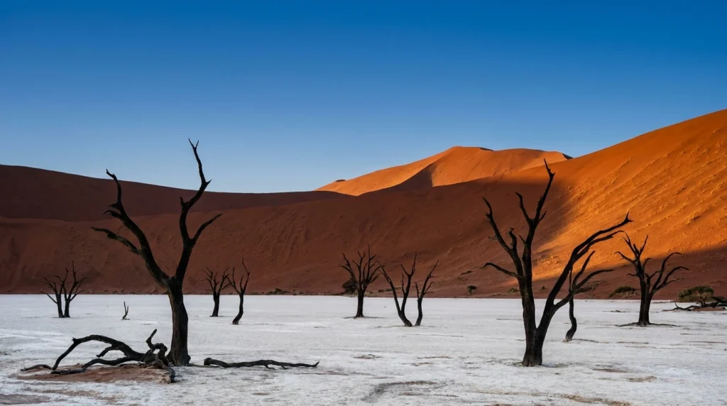
The biggest, oldest sand sea in the southern hemisphere starts roughly 350 km south-west of Windhoek and runs unbroken to Lüderitz. The Sesriem entry gate sits 5 km from Sesriem Camp; from there it is a 60 km tarmac strip past Dune 45 (80 m tall, 5 million-year-old sand) to the 2WD car park at Sossusvlei, then a 6 km soft-sand transfer (4×4 only, or shuttle) to the Sossusvlei main pan. Two kilometres on foot from the car park lies Deadvlei, the photographic crown jewel — a flat clay floor studded with the blackened skeletons of 900-year-old camel-thorn trees, hemmed in by Big Daddy at 325 m, the tallest dune in the immediate area. The Namib Sand Sea is a UNESCO natural property since 2013 (3,077,700 ha), inscribed under all four natural-criteria categories — only a handful of properties on Earth carry that distinction.
Etosha National Park
Etosha was proclaimed a game reserve in March 1907 by German governor Friedrich von Lindequist and elevated to national-park status in 1967; today the park covers 22,270 km², dominated by the 4,760 km² Etosha Pan (“Great White Place”) at its core. Three main gates — Anderson (south), Galton (south-west) and Von Lindequist (east) — control entry; the three big rest camps (Okaukuejo, Halali, Namutoni) sit roughly evenly spaced along the southern edge of the pan. The park’s mammal-list runs to 114 species, including all of the Big Five except buffalo, with around 2,500 elephant, healthy lion prides and approximately a third of Africa’s free-roaming black rhino. Self-drive sightings are excellent during the dry season (May–October); guided night-drives operated from the rest camps add genets, civets, brown hyena and the chance of leopard.
Damaraland & the Brandberg
Damaraland is the rumpled, copper-coloured plateau between Etosha and the Skeleton Coast — geologically among the oldest exposed surfaces on Earth, biologically the home of one of the planet’s two known populations of “desert-adapted” elephants and the entire wild population of “desert” black rhino monitored by Save the Rhino Trust Namibia. The flagship attractions are Twyfelfontein (Namibia’s first cultural UNESCO site, 2007, with more than 2,500 rock engravings spanning 6,000 years), the Petrified Forest, the Organ Pipes basalt formation and the Brandberg massif, whose Tsisab Gorge holds the famous “White Lady” rock painting. The Palmwag, Doro !Nawas and Torra conservancies host community-run lodges where rhino-tracking on foot with a Khoadi-Hôas-trained tracker is, in 2026, the single best wildlife experience in the country.
Skeleton Coast & Cape Cross
The Skeleton Coast is the 500 km Atlantic shoreline north of the Ugab River, a fog-bound arc of dunes, gravel plains and shipwrecks created by the cold Benguela Current’s collision with the inland desert. The Skeleton Coast National Park covers 16,000 km² with a permit-only northern wilderness section reachable only by fly-in to the Hoanib River concession; the southern half (the National West Coast Recreation Area) is accessible via a tarmac road from Swakopmund through Henties Bay. The Cape Cross Cape-fur-seal colony, 60 km north of Henties Bay, is the largest in the Atlantic with 80,000–100,000 individuals between October and December; the smell is iconic, the noise is louder than you expect, and the historic 1486 Diogo Cão padrão replica stands on the headland above.
Caprivi / Zambezi Region
The Caprivi Strip — officially renamed Zambezi Region in 2013 — is Namibia’s narrow north-eastern panhandle, a leftover of Chancellor Leo von Caprivi’s 1890 Anglo-German treaty that was meant to give Germany a Zambezi-river outlet (Victoria Falls promptly demonstrated this was unnavigable). Today the strip is the wettest, greenest, most water-rich part of Namibia (rainfall above 600 mm), home to three national parks (Bwabwata, Mudumu, Nkasa Rupara), seasonal elephant corridors crossing into Botswana, Zambia and Angola, and 70% of the country’s African wild-dog population. Add it to your itinerary if you have 21+ days and a willingness to take malaria prophylaxis; the typical entry is from Botswana through the Ngoma border post or as a self-drive extension out of Etosha.
Lüderitz, Kolmanskop & the Diamond South
Lüderitz is a tiny Wilhelmine-era Atlantic port wedged between the dunes and the sea on the south-west coast — Goerke Haus, the Felsenkirche and the harbourside Wilhelmstrasse give it the cinematic surrealism of Bavaria-on-the-South-Atlantic. Ten kilometres inland sits Kolmanskop, the diamond ghost town founded in 1908 after a railway worker stumbled on a stone, peaking with a casino, hospital, ice factory and Africa’s first X-ray machine, and abandoned wholesale in 1956 once richer deposits were found further south. The dunes have spent the seventy years since reclaiming the rooms — visitors now walk knee-deep in sand through a pastel-green ballroom — and a population of rare brown hyena uses the tumbledown houses as den-sites. Permits are issued at the gate; sunrise tours are sold out a day in advance during German school holidays.


Cultures & Peoples — Himba, Herero, San, Damara, Nama, Owambo
Namibia’s three million people speak more than thirty languages between them and divide along eleven main ethnic lines, and that visible diversity is one of the most rewarding parts of a thoughtful trip. The 2023 census put the Owambo at roughly half the population (the largest group), the Kavango at 9.4%, the Herero at 7%, the Damara at 8.5%, the Nama at 4.8%, the Caprivians at 5.5%, the San (Bushmen) at 2.4% (71,201 individuals), and the Himba — a sub-group of the OvaHerero — at 35,221. White Namibians (German-speaking, Afrikaans-speaking and English-speaking) and “Coloured” or Basters number roughly 5–6% combined.
The Himba — Pastoralists of the Kunene
The Himba are semi-nomadic cattle pastoralists who live in the Kunene Region (the area formerly called Kaokoland) and across the border into Angola’s Cunene Province. The 2023 Namibian census recorded 35,221 Himba inside Namibia of an estimated total of 50,000. They speak OtjiHimba, a dialect closely related to Otjiherero, and their visual signature — the otjize ochre-and-butterfat paste women apply to their skin and braided hair — is at once a sunscreen, an insect-repellent, a cleansing replacement for scarce water and a profound aesthetic statement of “earth’s rich red colour and blood, the essence of life.” Visiting a Himba village is sensitive ground — go only with a Himba-led or community-conservancy operator from Opuwo, never photograph people without permission, and bring useful gifts (maize meal, sugar, school supplies) rather than money or sweets.
The Herero — The Long Dresses, the Genocide, the Memory
The Herero number roughly 329,000 across southern Africa, with 178,987 OvaHerero recorded in Namibia’s 2023 census. They speak Otjiherero (a Bantu language), historically counted wealth in cattle, and survived the 1904–1908 German colonial genocide that killed an estimated 65,000 of their ancestors and forced the survivors into exile in Botswana and South Africa. The most distinctive surface marker today is women’s traditional dress — a floor-length, voluminous, high-necked gown adapted from late-nineteenth-century German missionary clothing and worn now as a defiant cultural inversion, paired with the otjikaiva, a horizontal horned headdress that symbolises respect for cattle. Annual commemorative parades through Okahandja each August honour the genocide victims and the Herero kings buried there.
The San — Original Custodians of the Kalahari
The San (sometimes Bushmen) are the world’s oldest continuous hunter-gatherer culture, the genetic ancestors of every modern human population. The 2023 census enumerated 71,201 San in Namibia (2.4% of the population), the highest proportion of any country except Botswana. Their languages — split across the Khoe, Tuu and Kxʼa families — are famous for their click consonants (four to five distinct click types, depending on dialect) and remain the only languages on Earth where clicks form a primary phonemic class. Today most San live in the Tsumkwe district (Otjozondjupa) and the Kalahari corridor; cultural visits to !Khwa ttu, Naankuse Wildlife Sanctuary’s San programme or the Living Museum at //Xa//oba are the most ethical entry points and direct revenue back to the communities.
The Damara, Nama & Owambo
The Damara number 219,203 (8.5% of Namibians) and live primarily in the north-west, speaking Khoekhoegowab — a click-language they share with the Nama despite very different ethnic origins; genetic research suggests they descend from Bantu speakers who shifted to a Khoekhoe language. The Nama are the southern Khoekhoe-speaking group whose homeland straddles the Orange River; they are the people who, alongside the Herero, faced extermination orders during the 1904–1908 colonial war. The Owambo are the demographic majority — about half the country’s population, around 1.5 million people, divided across eight closely related Bantu sub-groups (Ndonga, Kwanyama, Kwambi and others) clustered in the Cuvelai-Etosha basin from north of Etosha to the Angolan border. Oshiwambo (specifically the Oshindonga and Oshikwanyama dialects) is the most-spoken home language in the country at 48.9%.
A quick etiquette note before you start meeting people: greetings matter enormously. Always shake the right hand (the left is occasionally read as disrespectful in Owambo and Caprivian contexts), use both hands when receiving anything, and learn at least “morro” (good morning, Khoekhoegowab), “wa lalapo” (good morning, Oshiwambo) or the universal Afrikaans “goeiemôre”. Photography of people, ceremonies, schools and government buildings always requires permission first; permission given for an individual photograph is not a license to publish on social media without further consent.

A Food Lover’s Guide to Namibia — Kapana, Biltong, Oryx & the German Legacy
Namibian cuisine is a layered argument between three traditions: the indigenous gathering-and-game food cultures of the San, Damara and Owambo; the South African braai-and-biltong vocabulary that drifted up after 1915; and the Wilhelmine German baking, brewing and butchery tradition that survived in Lüderitz, Swakopmund and central Windhoek long after independence. The result, in 2026, is one of the most distinctive food cultures on the African continent — and one of the most under-rated.
Kapana & the Open-Air Brazier
Kapana is the country’s most accessible street-food tradition: thin slices of seasoned beef, cooked over open-air braziers at city-edge markets and sold by weight, eaten standing up with chilli salt, raw onion and a slab of vetkoek (deep-fried dough bread). The two unmissable pilgrimages are Single Quarters Market in Katutura (Windhoek) and the smaller informal kapana stalls outside Mondesa township in Swakopmund. Bring small notes, eat what your neighbour eats, and tip the salter — the chilli mix is what separates one stall from another.
Biltong, Droëwors & Game Meat
Biltong is air-dried, vinegar-and-coriander-cured strips of beef or game (kudu, oryx, springbok and the occasional eland), the Afrikaans-speaking world’s answer to American jerky but drier, leaner and far more chew-resistant. Droëwors is the same flavour profile in dried-sausage form. The country’s most iconic restaurant meal — fillet of oryx (gemsbok) with a red-wine reduction at Joe’s Beerhouse in Windhoek — is the canonical introduction to game; for a fancier version try the Stellenbosch Wine Bar. Game is sustainable in Namibia in a way it rarely is elsewhere because conservancy management actively requires culling quotas; eating it on a Namibian conservancy lodge menu directly funds anti-poaching wages.
Oshiwambo, Damara & Indigenous Staples
Travel north of the Red Line (the veterinary cordon at the southern edge of the Owambo region) and the food vocabulary changes completely. Oshifima (a stiff millet-meal porridge), oshikundu (a fermented millet-and-sorghum drink), and dishes built around mahangu (pearl millet), pumpkin leaves, mopane worms and freshwater bream from the Kavango and Zambezi rivers replace the southern braai script. Damara cuisine adds /khari (sun-dried beef from a particular dorsal cut), spinach-and-cocoyam stew, and milk-curd cheeses; the Living Museums in northern Namibia run cooking demonstrations that are easily the best food-anthropology hour you can buy on a Namibian trip.
For broader food-history context, the SBS Food project, the BBC Good Food Africa pages, the OECD’s measuring-the-economic-impact-of-tourism work, the World Travel & Tourism Council (WTTC) and the African Development Bank country diagnostic each carry useful supplementary material on Namibian gastronomy and the tourism economy that frames it. The country’s wine and craft-beer scene is small but growing, and the South African Brewers Institute and the Beer Judge Certification Program publish style notes that map onto Namibia Breweries’ Reinheitsgebot lagers.
The German Legacy — Schnitzel, Apfelstrudel, Brezel
Wiener schnitzel, sauerkraut, Rouladen, Apfelstrudel and Schwarzwälder Kirschtorte all survive on Namibian menus more than a century after the German colonial period ended; Swakopmund’s Café Anton (since 1957) and Windhoek’s Sardinia’s continue to bake to genuinely Bavarian standards. The country’s two flagship lagers — Windhoek Lager and Tafel Lager, both from Namibia Breweries Limited — are brewed strictly according to the 1516 Reinheitsgebot purity law and are widely held to be among the best beers in southern Africa. The Reinheitsgebot stamp matters: it forbids adjuncts (rice, corn syrup) and gives Namibian lager a clean malt finish you do not get from most South African mainstream brands.
Signature Dishes & Where to Eat Them
| Dish | What it is | Where to eat the canonical version |
|---|---|---|
| Kapana | Open-brazier-grilled beef slices, chilli salt, vetkoek | Single Quarters Market, Katutura (Windhoek) |
| Oryx fillet | Game-meat fillet, red-wine reduction, mash | Joe’s Beerhouse, 160 Nelson Mandela Ave, Windhoek |
| Biltong / droëwors | Air-dried cured beef or game | Krützfeldt’s, Swakopmund (1932) |
| Oshifima & oshikundu | Millet porridge with sour-fermented drink | Living Museum of the Owambo, Tsumeb area |
| Apfelstrudel & coffee | Bavarian apple-strudel pastry, hand-laminated | Café Anton, Swakopmund (since 1957) |
| Windhoek Lager | Reinheitsgebot lager, 4% ABV | Anywhere — but best at the brewery taproom in Windhoek |
| Crayfish (West Coast rock lobster) | Atlantic lobster, butter-grilled | The Tug, Swakopmund jetty (Nov–Apr season) |
Off the Beaten Path — Spitzkoppe, Kaokoland & the Quiver Tree Forest
Even Namibia’s flagship sights are uncrowded by African standards, but the country has another tier of places that almost no one on a 14-day standard route ever sees. The five below repay the extra fuel and the extra patience in full.
Spitzkoppe — The “Matterhorn of Namibia”
Spitzkoppe is a cluster of bald granite inselbergs rising abruptly from the gravel plains between Usakos and Swakopmund, the highest peak topping out at 1,728 m above sea level and roughly 670 m above the surrounding desert. The granite is more than 120 million years old, the rock-art shelters scattered around its base were inhabited by San hunter-gatherers for several thousand years, and the famous “Bushman’s Paradise” panel near the eastern campsite shows a clean sequence of giraffe, oryx and elephant engravings. Stanley Kubrick used Spitzkoppe as the otherworldly backdrop for the opening sequence of 2001: A Space Odyssey — a recommendation in itself. Camp at the community-run Spitzkoppe Campsite, no electricity, sky overhead, total quiet.
Kaokoland — The Last Wild Place in Namibia
Kaokoland is the local name for the deep north-west corner of the Kunene Region — roughly 49,000 km² of red gravel plain, dolerite ridges and dry riverbeds, almost no road network, no formal settlements above Opuwo and Sesfontein. It is where the country’s last desert-adapted elephants and lions roam, where the Hartmann’s mountain zebra population is densest, and where almost all of the Namibian Himba live their semi-nomadic year. The classic self-drive route runs Opuwo → Epupa Falls (on the Kunene River, the Angolan border, where Carmine bee-eaters nest in the cliff) → Marble Mountain → Van Zyl’s Pass (4×4 only, two vehicles minimum, satellite messenger essential) → Purros → Sesfontein. Allow ten days, carry 60 litres of water and a spare tyre per vehicle, never travel solo.
Fish River Canyon — The Largest Canyon in Africa
The Fish River Canyon plunges 549 metres at its deepest point and runs 160 km along Namibia’s far southern interior — the second most-visited tourist attraction in the country after Sossusvlei. The 90 km hiking trail from Hobas to ǀAi-ǀAis is one of the great wilderness treks of southern Africa: five days, no marked path, no facilities, no exit points, permits issued only between 1 May and 15 September because the canyon floor exceeds 48 °C in summer and is liable to flash-flooding. Permits sell out 9–12 months in advance through Namibia Wildlife Resorts; minimum group size is three. If you cannot trek, the Hobas viewpoint at sunrise is still extraordinary, and the ǀAi-ǀAis hot springs (60 °C natural geothermal water) make a fine recovery soak.
Quiver Tree Forest & the Giant’s Playground
About 14 km north-east of Keetmanshoop on a private farm sits Namibia’s most photographed grove — roughly 250 quiver trees (Aloidendron dichotomum), a vulnerable succulent endemic to the Northern Cape and southern Namibia and used by the San to hollow tubular branches into arrow quivers, hence the name. The species is now listed as Vulnerable on the IUCN Red List because climate change is shrinking its range from the south. A few kilometres further on, the Giant’s Playground is a chaos of basalt boulders the size of cars, stacked like a child’s building blocks by 180-million-years-old volcanic erosion. Combined entry ticket; both sites are easy half-day stops on the way to Fish River from Windhoek.
Sandwich Harbour — The 4×4 Day-Trip from Walvis Bay
Sandwich Harbour is a 7,500-hectare lagoon and dune-cliff system 50 km south of Walvis Bay, one of southern Africa’s most important coastal wetlands and a designated Ramsar site since 1995. Reaching it requires a guided 4×4 day-trip out of Walvis Bay (operators include Sandwich Harbour 4×4 and Turnstone Tours) — the route runs along the high-tide line, then crests the 100-metre dune face that drops directly into the Atlantic, in places a 35° gradient that reduces first-time passengers to silence. The lagoon supports 30,000+ migratory waders in November and a small Cape-fur-seal haul-out year-round; it is the closest most travellers come to genuinely roadless Namibian coast.


Practical Information
The cheat-sheet below covers the questions your travel-insurance agent, your phone provider and your border-control official are about to ask. Pin it.
| Field | 2026 Detail | Source |
|---|---|---|
| Visa | Visa-on-arrival or e-visa for US/UK/EU/Canada/Australia citizens since 1 April 2025; ≈USD $88 for 90 days | |
| Currency | Namibian Dollar (NAD), pegged 1:1 to South African rand; both legal tender | |
| Phone & data | MTC and Telecom Namibia tourist SIMs at Hosea Kutako; ≈NAD 200 for 10GB; eSIM via Airalo works countrywide except deep Kaokoland | |
| Tap water | Safe in Windhoek, Swakopmund, Walvis Bay, Lüderitz; bottled in remote conservancies | |
| Malaria zones | Risk in Kavango, Kunene (north), Zambezi/Caprivi, Oshana, Ohangwena, Omusati, Otjozondjupa, Oshikoto, Omaheke (Nov–Jun); zero risk in Windhoek, Sossusvlei, Etosha rest camps in dry season | |
| Vaccinations | Routine + Hepatitis A & B + Typhoid for rural travel; yellow fever certificate required only if arriving from a yellow-fever country | |
| Plug type | Type D (3 round pin) and Type M (large 3 pin); 220V / 50Hz — South African adapter | |
| Time zone | UTC+2 (Central African Time, no daylight savings since 2017) | |
| Drives on | Left (legacy of South African administration); valid international driving permit accepted | |
| Emergency | 112 (police, fire, ambulance from any mobile); MedRescue 081 924 for medevac |
Cross-checks against the United Nations Statistics Division, the World Health Organization country profile, the US State Department’s travel advisory, the UK Foreign & Commonwealth Office, the Government of Canada travel page and Smartraveller (Australia) confirm Namibia’s “exercise normal precautions” baseline rating throughout 2026. Currency conversion is at par with the South African rand and is published daily by the South African Reserve Bank and tracked by XE.com and OANDA.
Budget Breakdown — What Namibia Actually Costs in 2026
Namibia is unusual among first-tier safari destinations because the cost gap between camping self-drive and fly-in luxury is the widest in southern Africa. A frugal couple can travel the entire country for two weeks on the price of three nights at a Botswana fly-in concession. The numbers below assume a couple sharing accommodation and a vehicle; solo travellers add roughly 40% per day, families with two children subtract about 25% per person.
Budget — Camping Self-Drive (USD $90–140 / day)
A double-cab Hilux with rooftop tent, pre-booked NWR campsites and Pick n Pay groceries from Windhoek. Campsites at Sesriem, Etosha (Okaukuejo, Halali, Namutoni), Swakopmund Tiger Reef and Spitzkoppe Community Campsite cost NAD 360–520 per pitch per night (≈USD $20–28). Fuel runs around USD $25–35 per day for the standard 14-day route, food USD $20–30 per day cooked over the rooftop-tent’s pull-out kitchen, park fees a flat USD $5 per person per day. Add bed-nights at backpacker hostels (Cardboard Box in Windhoek, Skeleton Beach Backpackers in Swakopmund) when you tire of canvas.
Mid-Range — Lodge Self-Drive (USD $220–380 / day)
The country’s middle market is its strongest. Gondwana Collection lodges (Canyon Roadhouse near Fish River, Desert Quiver Camp near Sesriem, Damara Mopane Lodge near Twyfelfontein) typically charge USD $130–180 per person per night including breakfast and dinner; Ondili and Namib Sky Balloon Safaris fall in the same band. Add a sedan rental (USD $55–80/day in shoulder season), full fuel, daily park fees and a couple of activities (sunrise hot-air balloon over Sossusvlei: USD $480 per person; Sandwich Harbour 4×4: USD $145) and most travellers land in the USD $260–340 daily range.
Luxury — Fly-In Concessions (USD $750+ / day)
Wilderness Safaris (Hoanib Skeleton Coast, Serra Cafema), &Beyond (Sossusvlei Desert Lodge), Natural Selection (Hoanib Valley, Shipwreck Lodge) and Onguma’s Camp Kala sit at the top of the market — all-inclusive rates run USD $900–1,800 per person per night with private guide, all activities, all drinks, light-aircraft transfers and (at Hoanib and Shipwreck) tracking of desert-adapted wildlife. The flight time saved versus self-drive is significant — Windhoek to Hoanib is 90 minutes by Cessna versus two long days by gravel road — and the per-couple budget for a 7-night fly-in circuit lands around USD $14,000–24,000 all-in. The 9% Tourism Levy and 15% VAT are usually included in the quoted rates; tips of USD $15–20 per person per day for guides and USD $8 per person per day for back-of-house remain customary.
| Item | Budget | Mid-Range | Luxury |
|---|---|---|---|
| Bed (per person) | USD $20–35 | USD $130–200 | USD $900–1,800 all-in |
| Vehicle (per day) | $60 sedan | $95–140 4×4 with tent | Charter flights only |
| Fuel (per day) | $25 | $35 | n/a (chartered) |
| Restaurant dinner | $8 kapana plate | $20–30 oryx fillet | $60+ tasting menu |
| Windhoek Lager (500ml) | $1.80 supermarket | $3 lodge bar | included |
| Etosha day-fee | NAD 150 (≈$8) per adult | NAD 150 | included |
| Sossusvlei balloon | n/a | $480 / person | included on some itineraries |
Planning Your First Trip to Namibia — Five Steps
-
1. Pick the right window — late August to early October
For first-timers in 2026 the single best stretch is roughly 25 August to 10 October — Etosha waterhole concentrations are at peak, the Fish River trail permit is still open (closes 15 September), Sossusvlei mornings are cold but no longer freezing, and the South African school holidays clear out by the second week of October.
-
2. Book the gateway nights early
Sesriem inner-park camp, Okaukuejo, Halali and Namutoni in Etosha, and Sossus Dune Lodge sell out 6–9 months ahead in dry season. Reserve those four anchor nights through Namibia Wildlife Resorts the same week you book your international flight. The rest of the itinerary is far more flexible.
-
3. Apply for the e-visa seven days before flight
Since 1 April 2025, US/UK/EU/Canada/Australia citizens need either an e-visa or a visa-on-arrival. The e-visa avoids the WDH counter queue at 06:00 after a 10-hour Frankfurt flight; pay USD $88 online, attach passport scan, save the PDF to your phone.
-
4. Reserve a high-clearance 4×4 with rooftop tent
Asco, Bushlore, Britz Namibia, Caprivi Car Hire, SafariCar — pick any of the established operators, lock the booking 4–6 months out for dry-season pickups, and confirm two full-sized spare wheels, a 12V compressor, a National Park “off-road permit” sticker, and recovery gear. Decline the cheapest insurance package; pay the surcharge for full-tyre-and-windscreen cover.
-
5. Build the route around the four anchors
Day 1 Windhoek (acclimatise, museum, Joe’s). Days 2–4 Sossusvlei via the C19/D826. Days 5–6 Swakopmund (sundowner at The Tug, Sandwich Harbour 4×4 or Welwitschia drive). Days 7–8 Damaraland (Twyfelfontein, rhino tracking). Days 9–12 Etosha (Okaukuejo → Halali → Namutoni). Day 13–14 Onguma or Mushara, then drop the 4×4 in Windhoek. Pad an extra night on either end if you can — Namibian distances always look smaller on a map than they drive.
Frequently Asked Questions
Is Namibia safe for self-drive travellers in 2026?
Yes, with the obvious caveats around gravel roads. Namibia ranks consistently in the top 10 safest African countries on the Global Peace Index, violent crime against tourists is rare outside Windhoek’s downtown after dark, and the self-drive infrastructure is the most foreigner-friendly on the continent. The genuine risk is gravel-road rollovers and animal-strike between sunset and sunrise — nearly every fatal tourist accident is one of those two scenarios. Drop tyre pressure to 1.8 bar before leaving tarmac, never travel after dark, never exceed 80 km/h on gravel.
Do I need a visa as a US, UK, EU, Canada or Australia citizen?
Yes, since 1 April 2025. Namibia abolished the visa-free regime for 33 nationalities — including all of the above — citing reciprocity. You have two paths: an e-visa applied for online seven days before flight, or a visa-on-arrival counter at Hosea Kutako that costs about USD $88 for 90 days and accepts card payment. Bring a passport with at least six months of remaining validity and one blank facing page. African Union member-state citizens still pay only USD $66.
When is the best month to visit Etosha?
September. By September every ephemeral pan in the park has dried up, the Etosha Pan rim has been dry for months, and the only standing water across 22,270 km² is the seven contact-springs and pumped boreholes around Okaukuejo, Halali, Namutoni, Klein Namutoni, Goas, Kalkheuwel and Olifantsbad. Wildlife is forced to queue at these waterholes — black rhino, elephant, lion and giraffe at the same drink-line, often within a single afternoon. August and the first week of October are nearly as good. Avoid February to April unless birdwatching is your priority — game disperses widely after the rains.
Is malaria a real risk?
Only in the northern third of the country and only during the rainy season (November–June). Windhoek, Sossusvlei, Swakopmund, Walvis Bay, the Skeleton Coast, southern Damaraland and the entire south have effectively zero malaria transmission. The Caprivi/Zambezi panhandle, Kavango, the northern Kunene (Epupa Falls area) and parts of Etosha North do carry plasmodium-falciparum risk during the rains; standard atovaquone-proguanil, doxycycline or mefloquine prophylaxis is the practical answer for any November-to-June trip into those zones. The CDC also flags a 2024–25 rabies outbreak in Cape-fur seals along the coast — don’t approach them, ever.
Can I drink the tap water?
In Windhoek, Swakopmund, Walvis Bay and Lüderitz, yes — municipal supply is treated to South African SANS 241 standards and Namibia is famously the only country in the world supplying its capital with reclaimed sewage water (the Goreangab Reclamation Plant has done so since 1968 without a single confirmed disease outbreak). At remote campsites, conservancy lodges and in the Caprivi/Zambezi, drink filtered or bottled water; lodges typically supply both.
Do I really need a 4×4?
Not strictly. A standard 2WD sedan can reach Sossusvlei (parks at the Sossusvlei 2WD car-park, then shuttle), all of Etosha’s main loop, Swakopmund, and Twyfelfontein. You will need a 4×4 to reach Sandwich Harbour, the Sossusvlei main pan car-park, Sesriem inner-camp campsites, the Hoanib River and the entire Kaokoland north of Sesfontein. The strong recommendation for a first trip is a high-clearance 4×4 with a rooftop tent — it doubles your daily flexibility, halves your nightly accommodation cost, and makes gravel-road tyre damage far less likely.
Is Namibia expensive?
Less than Botswana, less than Kenya, slightly more than South Africa. A camping self-drive couple lives on USD $90–140 a day all-in; a mid-range lodge couple lives on USD $220–380; a luxury fly-in week lands at USD $14,000–24,000 per couple. Park fees are low (NAD 150 per adult per day in Etosha), fuel is cheap by European standards, and Namibian Lager at NAD 30–50 in restaurants is a steal. The cost trap is fly-in concessions in Damaraland and the Skeleton Coast — Wilderness, &Beyond and Natural Selection rates are firmly luxury-tier.
Are the Himba villages ethical to visit?
Yes — but only if you go with a Himba-led conservancy operator from Opuwo, never with a “drop-in” tour out of Swakopmund. Himba women have spoken on record about the dehumanising effect of unannounced bus tours; the equivalent ethical visits go through Marble Mountain Tours, Kaokohimba Safaris or the Living Museum at Otjikandero, all of which return revenue directly to the families. Bring useful gifts (maize meal, sugar, school supplies), never sweets or money, never photograph children without explicit permission from a parent, and never publish photographs that identify a family on social media without consent.
What about photography ethics in general?
The standard southern African rule applies and is strictly enforced socially: ask first, every time. Government buildings, military installations, the diamond-mining areas around Oranjemund and the eastern Tsumkwe corridor explicitly prohibit photography; airports prohibit it within the security zone. Workshops and guides increasingly stop the vehicle when an opportunistic photo of a Himba or Herero woman is taken without consent — and rightly so. Ten seconds of greeting and a polite “may I take a picture?” buys you both better photographs and a clean conscience.
Ready to Explore Namibia?
Two UNESCO sites, the world’s oldest desert, the largest free-roaming black-rhino population on Earth, more than half the country in some form of community-managed conservancy, and a road network that lets you self-drive every single one of those wonders without a charter pilot. Book your Sesriem and Etosha rest-camp nights the same week your flight is confirmed, time the trip for late August through early October, drop the tyre pressure to 1.8 bar before the gravel — and let the silence rearrange your week.
Explore More
Namibia’s own cities — Windhoek, Swakopmund, Walvis Bay and Lüderitz — feature throughout the regions above; dedicated FFU city guides for them are in production. In the meantime, browse our live flagship city guides for trip inspiration:
More country guides you might like
Plan your trip to Namibia Travel Guide
The booking tools we use ourselves. FFU may earn a commission at no extra cost to you.