
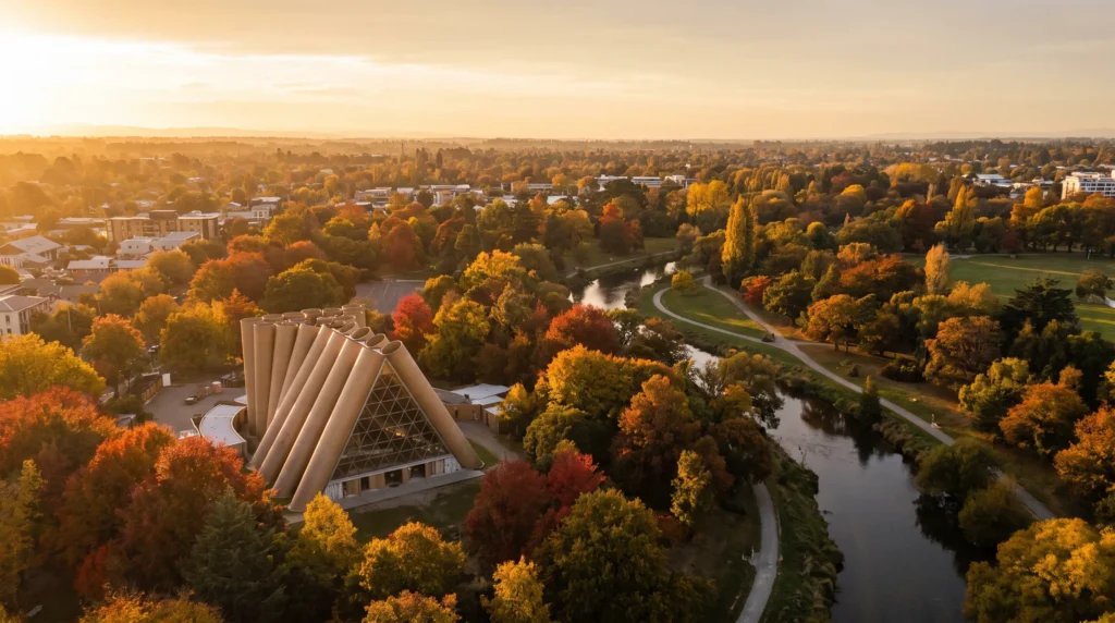
Christchurch Travel Guide — The Garden City That Rebuilt Itself Into New Zealand’s Most Honest Comeback Story
I’ll say the quiet part first: Christchurch is not trying to be Queenstown, and that’s exactly why I keep sending people here. This is a city that took a magnitude 6.3 earthquake on 22 February 2011, lost 185 people and a huge share of its historic core, and then spent the following decade rebuilding in full public view. You can still see the seams — a gap site here, a temporary cardboard cathedral there — and that visible scar tissue is what makes the city feel more real than almost anywhere else in New Zealand. Punt down the Avon River past Hagley Park, eat at a Michelin-recognised restaurant that didn’t exist ten years ago, then drive ninety minutes over a volcanic rim to a French-founded harbour town, and you start to understand why New Zealanders themselves talk about Christchurch’s revival with genuine pride. It’s flatter, cheaper and less crowded than Auckland or Queenstown, it’s the country’s official gateway to Antarctica, and it rewards travelers who like a place with a story rather than a place that’s just pretty.
In This Guide
- Overview — Why Christchurch Is New Zealand’s Most Honest City
- Festival Season — World Buskers, Blooms & the Southern Alps
- Best Time to Visit Christchurch (Season by Season)
- Getting There — CHC Airport, TranzAlpine & Intercity Coaches
- Getting Around — Trams, e-Scooters & the Metro Bus Network
- Neighborhoods — CBD, Sumner, Riccarton & the Port Hills
- Culture & People — Rebuild, Resilience & Ngāi Tahu
- A Food Lover’s Guide to Christchurch
- Off the Beaten Path
- Day Trips — Akaroa, Arthur’s Pass & Lyttelton
- Practical Information
- Budget Breakdown — What Christchurch Actually Costs in 2026
- Planning Your First Trip to Christchurch
- Frequently Asked Questions
Overview — Why Christchurch Is New Zealand’s Most Honest City
Christchurch — Ōtautahi in Māori — is the South Island’s largest city and, by most tellings, New Zealand’s oldest formally established one: British settlers arrived aboard the “First Four Ships” in 1850, and the settlement was granted city status by royal charter on 31 July 1856. That colonial-era planning gave it wide boulevards, a genuinely grand Gothic Revival streetscape, and an oversized central park — Hagley Park, laced by the looping Avon River — that still anchors the city today.
Then, on 22 February 2011, a shallow magnitude 6.3 earthquake tore through the central city, killing 185 people and destroying or condemning much of the historic core, including the original Christ Church Cathedral. What followed is the part visitors underestimate: rather than paper over the damage, Christchurch rebuilt in public — shipping-container malls, a “Cardboard Cathedral” designed pro bono by Pritzker-winning architect Shigeru Ban, and a wave of contemporary architecture and street art filling the gaps. Fifteen years on, the city reads less like a disaster site and more like a live case study in how a place chooses to come back.
Today Christchurch has an urban population of roughly 408,000, with around 556,500 across the wider metro area, making it the South Island’s undisputed hub and New Zealand’s second city by most measures. It sits on flat Canterbury Plains between Pegasus Bay and the volcanic Port Hills, with the Southern Alps visible on a clear day and the ancient caldera of Banks Peninsula forty minutes to the southeast. It’s also one of only five official Antarctic “gateway cities,” hosting the logistics bases for the US, New Zealand and Italian Antarctic programs — a genuinely odd and wonderful thing to stumble onto at the airport.
Festival Season — World Buskers, Blooms & the Southern Alps
Time a late-January or February trip around two things: the World Buskers Festival, which fills Cathedral Square and the Arts Centre with street performers from across the globe over about ten days, and the height of Canterbury’s summer, when Hagley Park’s rose gardens and the Botanic Gardens are at full bloom and evenings stay light past 9pm. It’s also peak season for the Michelin-recognised restaurant scene the city has quietly built since the rebuild — sixteen Christchurch restaurants now carry MICHELIN recognition, including two one-starred kitchens, Inati and Tussock Hill.
Come winter instead (June–August) and the pitch flips entirely: the city markets itself as “Made for Winter,” leaning on same-day access to Canterbury’s ski fields and the frost-clear Southern Alps views from the Gondola. Whichever season you land in, check the events calendar before booking — rugby weekends at One New Zealand Stadium and touring stadium acts (Robbie Williams and Foo Fighters both played Christchurch in 2026) can quietly double hotel rates across the whole city.
Best Time to Visit Christchurch (Season by Season)
November – April · Spring through early autumn (peak)
Warmest, driest and longest days, with January averaging around 22.6°C — this is when Hagley Park, the Botanic Gardens and outdoor dining are at their best, and when Akaroa day-cruise operators run full schedules. Book central hotels and the TranzAlpine ahead over the Christmas–New Year school holidays.
September – October & May · Shoulder value
Cooler and breezier, but noticeably cheaper, with spring blossom in the Botanic Gardens in September–October and crisp, clear autumn light in May. Good windows for the food scene without summer’s queues.
June – August · Winter
Cold — July averages around 10.9°C by day and frosty overnight — but reliably clear, which is exactly why it works as a base for the Canterbury ski fields (Mt Hutt, Porters, Craigieburn) and for crossing Arthur’s Pass on the TranzAlpine through fresh snow. Some Banks Peninsula operators reduce sailings; check ahead.
Getting There — CHC Airport, TranzAlpine & Intercity Coaches
Christchurch Airport (CHC) sits about 12 kilometres northwest of the city centre in Harewood and is New Zealand’s second-busiest, handling roughly 6.6 million passengers in 2025. International links run direct to Sydney, Melbourne, Brisbane, Gold Coast, Singapore, Guangzhou, Hong Kong, Nadi and — seasonally — San Francisco, the only direct North America–South Island route and, at over 13 hours, the airport’s longest haul. Most long-haul travelers connect through Auckland, Sydney or Singapore instead. A taxi or rideshare into the CBD runs 15–20 minutes; the Purple Metro bus line covers the same route for a fraction of the cost.
If you’re arriving overland from the North Island, InterCity coaches and the Interislander/Bluebridge ferries connect Wellington to Picton, with onward coach or rail links south. The single most memorable arrival, though, is the TranzAlpine — one of the world’s great scenic train journeys, running 223 kilometres from Greymouth on the West Coast through Arthur’s Pass and the 8.5km Otira Tunnel to Christchurch in around five hours. Arriving by rail through the Southern Alps beats any airport transfer.
Getting Around — Trams, e-Scooters & the Metro Bus Network
Christchurch is famously flat — one of the reasons it’s often called New Zealand’s most bike-friendly city — with a growing network of dedicated cycleways (“Major Cycleway Routes”) radiating from the centre. Rental e-bikes and e-scooters are everywhere downtown and genuinely useful for covering Hagley Park-to-CBD distances quickly.
The Metro bus network is the backbone for longer hops — to Sumner Beach, Lyttelton or Riccarton — and a Metrocard brings fares down noticeably versus paying cash on board. Within the four avenues of the central city, walking is easy and the free-to-ride heritage tram loop (a paid attraction, not commuter transit) is a pleasant way to get oriented past the rebuild’s landmark buildings. For Banks Peninsula, Arthur’s Pass or the Canterbury high country, a rental car is the practical choice — just remember New Zealand drives on the left, and rural state highways are narrower and slower than they look on the map.
Neighborhoods — CBD, Sumner, Riccarton & the Port Hills
Central City & Cathedral Square
The rebuilt heart of Christchurch: Cathedral Square, the Cardboard Cathedral a short walk away, the restored Arts Centre, and New Regent Street’s pastel Spanish Mission facades, now a tram stop and gelato strip. This is also where most of the newer Michelin-recognised restaurants have clustered.
Hagley Park & the Botanic Gardens
A green core larger than many small suburbs, wrapping the Avon River on both sides. Punt the river, wander the Botanic Gardens’ conservatories and rose beds, or just picnic — this is the single best free thing to do in the city.
Riccarton & Ilam
Home to the University of Canterbury and Riccarton Bush (Pūtaringamotu), a fenced remnant of original Canterbury Plains forest with some of the oldest kahikatea trees left standing in the region. A student-driven food and bar scene runs along Riccarton Road.
Sumner & the Coast
A beachside village tucked under the Port Hills’ eastern cliffs, with a real swimming beach, cafes, and the short walk out to Cave Rock. It’s the closest thing Christchurch has to a beach-town escape without leaving the city bus network.
Port Hills
The volcanic ridge separating the city from Lyttelton Harbour, laced with walking and mountain-bike tracks and capped by the Christchurch Gondola, whose summit station looks out over both the city and the harbour on a clear day.
Lyttelton
The city’s working port, on the harbour side of the Port Hills, reached by road tunnel or a walking track over the saddle. Colourful, hilly and a little bohemian, with a well-loved Saturday farmers’ market and the departure point for harbour cruises and the ferry to Diamond Harbour.
Addington & the South
Increasingly the city’s events and craft-beer corridor, anchored by One New Zealand Stadium and a cluster of breweries in converted industrial buildings — worth a detour on a match day or a wet afternoon.
Culture & People — Rebuild, Resilience & Ngāi Tahu
Christchurch sits within the rohe (tribal territory) of Ngāi Tahu, the principal iwi (Māori tribe) of most of the South Island, and Ngāi Tahu place names and cultural references — starting with Ōtautahi itself — are woven through the city’s public art, museum exhibits and street signage far more visibly than a decade ago.
The dominant cultural thread for visitors, though, is the rebuild itself: locals talk about “before” and “after” the quake the way other cities talk about wars, and the city’s identity now leans hard into resilience, reinvention and DIY creativity — the shipping-container Re:START mall, the street-art trail through the CBD, and community “gap fill” projects on vacant lots are as much a cultural attraction as any museum. English is the near-universal language of daily life, with Te Reo Māori increasingly visible on signage and in greetings, alongside New Zealand Sign Language as the country’s third official language.
A Food Lover’s Guide to Christchurch
Christchurch’s dining scene has quietly become one of New Zealand’s best, with sixteen restaurants carrying MICHELIN recognition and two one-starred kitchens — Inati, tucked in a converted CBD warehouse, and Tussock Hill, a Port Hills winery restaurant. Both need bookings well ahead.
For everyday eating, Canterbury lamb and South Island beef anchor most menus, alongside Akaroa salmon and Bluff oysters when in season (roughly March–August). The Riccarton and Lyttelton farmers’ markets are the best way to sample regional produce, and the craft-beer cluster around Addington reflects a genuinely serious brewing scene. A flat white and a “scroll” (a savoury cheese-and-marmite pastry) from a CBD cafe is the honest local breakfast — skip the international chains and follow the queue at an independent roastery instead.
Off the Beaten Path
International Antarctic Centre
Right next to the airport terminal, this is where the US, NZ and Italian Antarctic programs actually stage their South Pole logistics — the visitor centre alongside it runs Hägglunds rides and penguin encounters, but the real draw is realizing Christchurch has quietly been Antarctica’s back door since the early 1900s.
Riccarton Bush (Pūtaringamotu)
A fenced 7.8-hectare pocket of original Canterbury Plains podocarp forest inside a residential suburb — walk it in twenty minutes and see what this entire plain looked like before the First Four Ships arrived.
Christchurch Art Gallery & the Street Art Trail
The gallery itself is free and excellent, but the wider draw is the CBD’s post-quake street-art trail — dozens of large-scale murals commissioned into gap sites and rebuild walls, a genuinely unplanned open-air gallery that keeps expanding.
Diamond Harbour
A ten-minute passenger ferry from Lyttelton across the harbour to a quiet settlement with a pub, a walking track up Mt Herbert, and almost no tourists — a locals’ escape hiding in plain sight.
Day Trips — Akaroa, Arthur’s Pass & Lyttelton
Akaroa & Banks Peninsula
The classic Christchurch day trip: Akaroa sits on an ancient volcanic harbour about 83 kilometres and roughly 90 minutes’ drive southeast, founded in 1840 as a French settlement and still carrying French street names and a distinctly different architectural flavour from the rest of Canterbury. Harbour cruises here regularly spot Hector’s dolphins — the world’s smallest and rarest marine dolphin, found only in New Zealand waters — alongside little blue penguins and fur seals.
Arthur’s Pass & the TranzAlpine
Whether you ride the full TranzAlpine to Greymouth or just drive up for the day, Arthur’s Pass National Park delivers alpine scenery — beech forest, kea parrots, and waterfall walks around the tiny alpine village — about two hours from the city.
Lyttelton & the Port Hills
Doable as a half-day rather than a full one: drive or bus over the hill, browse the Saturday market, then walk or drive up to the Gondola summit for harbour-and-city views in the same trip.
Hanmer Springs
About two hours north, a compact alpine spa town built around geothermal hot pools — a popular overnight add-on for anyone extending north toward Kaikōura or the Marlborough wine region.
Practical Information
Money. The New Zealand Dollar (NZD) floats freely against other currencies; the Reserve Bank issues $5, $10, $20, $50 and $100 notes. Cards, including contactless and mobile pay, are accepted virtually everywhere — carrying much cash is rarely necessary.
Visa. Travelers from around 60 visa-waiver countries, including the US, UK, EU states and Canada, don’t need a visa but must obtain an NZeTA before travel — NZ$17 via the app or NZ$23 online, plus a mandatory NZ$100 International Visitor Conservation and Tourism Levy, and it’s linked electronically to your passport. Apply at least a few days ahead; processing is usually within 72 hours.
Safety. The US State Department rates New Zealand Level 1 — “Exercise Normal Precautions” — its lowest advisory tier, describing it as “generally a safe destination for travelers.” The advisory’s real headline risk for visitors is road trauma from unfamiliar left-hand, narrow-road driving conditions, not crime. Christchurch also sits in an active seismic zone; minor tremors are routine and nothing to panic about, but know where your accommodation’s emergency exits are.
Health. No vaccinations are required for entry, and the CDC lists only routine and travel-standard recommendations (MMR, seasonal flu, and Hepatitis A/B for some travelers) — nothing New Zealand-specific to worry about. Tap water is safe to drink nationwide.
Connectivity & practicals. An eSIM (Spark, One NZ or a regional provider) covers the city well; rural Banks Peninsula and Arthur’s Pass have patchier coverage. Plugs are Type I (the same three-pin standard as Australia), at 230V. Time zone is NZST/NZDT — the same zone as Auckland and Wellington nationwide.
Budget Breakdown — What Christchurch Actually Costs in 2026
Christchurch runs noticeably cheaper than Queenstown or Auckland, though New Zealand overall isn’t a budget destination by global standards.
Budget (US$70–120/day): Hostel dorm or budget motel, supermarket meals and food-court/cafe lunches, Metro bus fares, free Hagley Park and Botanic Gardens time, one paid attraction every couple of days.
Mid-range (US$180–320/day): Boutique CBD hotel or Sumner Airbnb, a mix of casual and sit-down restaurant meals, a rental car for a day or two, an Akaroa harbour cruise or the Gondola, maybe one TranzAlpine day return.
Luxury (US$500+/day): A Michelin-recognised tasting menu at Inati or Tussock Hill, a Port Hills or Banks Peninsula lodge, private wine or Antarctic Centre tours, business-class TranzAlpine or a Hanmer Springs spa night.
Fixed costs to expect: the one-time NZ$117+ NZeTA/levy per visit, and 10–15% is appreciated but not automatically added at most restaurants, unlike the US.
Planning Your First Trip to Christchurch
The efficient first-timer split is city plus one big day trip: two nights in the central city or Sumner covering Hagley Park, the Cardboard Cathedral, the Art Gallery and the street-art trail, then a full day out to Akaroa for the harbour, dolphins and French-village charm. Add a third or fourth night to ride the TranzAlpine to Arthur’s Pass, or push north to Hanmer Springs and Kaikōura. Christchurch also pairs naturally with the rest of the South Island — most visitors either fly in here and loop south to Queenstown and Fiordland, or use it as the bookend after driving the West Coast. If New Zealand is new territory entirely, our New Zealand country guide covers the full North-to-South itinerary picture, and our Wellington and Auckland guides fill in the North Island legs if you’re routing through both islands.
Frequently Asked Questions
Is Christchurch safe for tourists in 2026?
Yes — the US State Department rates New Zealand at its lowest risk tier, Level 1, and the country is broadly regarded as one of the safer places to travel. The realistic risk for visitors is road trauma from unfamiliar left-hand driving, not crime — drive cautiously, especially on rural Banks Peninsula roads.
Do I need a visa for New Zealand?
Citizens of around 60 visa-waiver countries, including the US, UK, EU and Canada, don’t need a visitor visa but must obtain an NZeTA (New Zealand Electronic Travel Authority) online or via app before travel, plus pay the mandatory International Visitor Levy — together roughly NZ$117–123. Apply a few days before departure.
Is the earthquake damage still visible?
Some — you’ll see gap sites, the still-“transitional” Cardboard Cathedral, and construction hoardings in places, alongside a genuinely rebuilt, modern central city. Fifteen years on, most of central Christchurch functions normally; the visible scars are part of the story rather than a reason to avoid it.
How many days do you need in Christchurch?
Two full days covers the city itself comfortably; three to four lets you add Akaroa and either the TranzAlpine or Hanmer Springs without rushing.
Christchurch or Queenstown?
Choose Christchurch for city culture, food, Antarctic history and easy day trips to a French-founded harbour town at a noticeably lower cost; choose Queenstown for concentrated alpine adventure sports and lake scenery. Many itineraries do both, using Christchurch as the flight gateway.
What’s the cheapest way to see Banks Peninsula?
A self-driven day trip with a packed lunch and a walk around Akaroa’s waterfront costs little beyond fuel; add a shared harbour cruise for the dolphins if the budget allows.
Ready to Explore Christchurch?
A punt down the Avon under willow trees, a cardboard cathedral that somehow works as both memorial and marvel, Hector’s dolphins off a French-founded harbour town ninety minutes away — Christchurch rewards travelers who want substance behind the scenery. It’s cheaper, flatter and quieter than New Zealand’s more famous stops, and it’s earned every bit of its comeback.
Explore More
- New Zealand Travel Guide — plan the full North-to-South itinerary
- Wellington City Guide — the capital, across the Cook Strait
- Auckland City Guide — New Zealand’s biggest city and main gateway
- Sydney City Guide — the closest major international hop from CHC
How this guide was built
Published as part of Facts From Upstairs’ city guide series. Built from authoritative sources — Wikipedia’s entity pages for Christchurch, Christchurch Airport, the Cardboard Cathedral, the TranzAlpine and the International Antarctic Centre; New Zealand Immigration’s official NZeTA page; the Reserve Bank of New Zealand’s money and cash page; the US State Department’s New Zealand travel advisory; the US CDC’s New Zealand traveler health page; and ChristchurchNZ, the city’s official tourism board. Numeric claims carry inline citations.
Sources cited on this page
- Wikipedia — Christchurch
- Wikipedia — Christchurch Airport
- Wikipedia — Cardboard Cathedral
- Wikipedia — TranzAlpine
- Wikipedia — International Antarctic Centre
- Immigration New Zealand — NZeTA
- Reserve Bank of New Zealand — Money and Cash
- US State Department — New Zealand Travel Advisory
- UK FCDO — New Zealand Travel Advice
- US CDC — New Zealand Traveler Health Page
- ChristchurchNZ — Official Tourism Board
- ChristchurchNZ — Akaroa & Banks Peninsula
More city guides you might like
Plan your trip to Christchurch
The booking tools we use ourselves. FFU may earn a commission at no extra cost to you.
Plan & book your trip to Christchurch
Booking through these searches supports our guides at no extra cost to you.