
Santa Marta Travel Guide — Colombia’s Oldest City, Where the Jungle Falls Straight Into the Caribbean
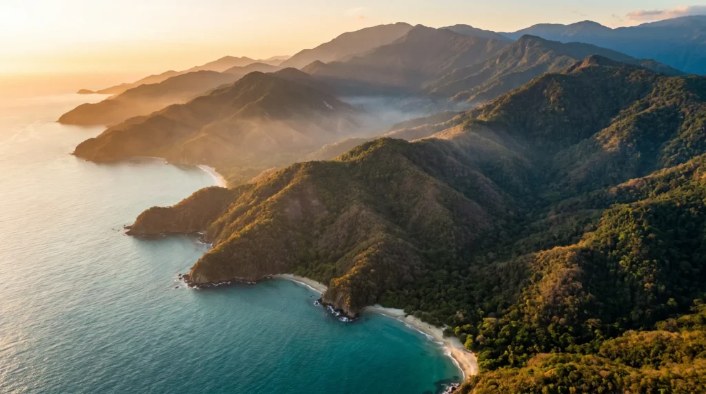
I’ve stood in a lot of places that claim to have “it all,” and most of them are lying. Santa Marta isn’t. This is the only spot on the planet where a snow-capped peak and a Caribbean beach sit close enough to see each other — the Sierra Nevada de Santa Marta rises to roughly 5,700 meters barely 42 kilometers from the coast, making it the highest coastal mountain range on Earth. Founded in 1525, it’s the oldest surviving city in Colombia — older than Cartagena, older than anything else on this coastline. For years it played the unglamorous younger sibling to Cartagena’s walled-city polish, which is exactly why it stayed real: a working port town that happens to be the gateway to a lost jungle city older than Machu Picchu, a UNESCO biosphere reserve, and some of the best-value beach time in the Caribbean. It’s rougher around the edges than Cartagena, the traffic downtown can be a genuine headache, and you need to plan around rainy months — but if you want reef, ruins, mountains and a five-century-old grid of streets in one week, this is the one place in Colombia that delivers all four without a connecting flight.
In This Guide
- Overview — Why Santa Marta Is Colombia’s Most Complete Coastline
- Fiestas del Mar — Santa Marta’s Sea Festival, July 23–29
- Best Time to Visit Santa Marta (Season by Season)
- Getting There — SMR Airport & Overland Routes
- Getting Around — Taxis, Colectivos & the Rodadero Cable Car
- Neighborhoods — Centro Histórico, El Rodadero & Beyond
- Culture & People — Tairona Roots, Kogi Wisdom & Bolívar’s Last Breath
- A Food Lover’s Guide to Santa Marta
- Off the Beaten Path
- Day Trips From Santa Marta
- Practical Information
- Budget Breakdown — What Santa Marta Actually Costs in 2026
- Frequently Asked Questions
Overview — Why Santa Marta Is Colombia’s Most Complete Coastline
Rodrigo de Bastidas founded Santa Marta on 29 July 1525, which makes it not just Colombia’s oldest surviving city but one of the oldest continuously inhabited Spanish settlements in South America. Simón Bolívar, the man who liberated half the continent, died here in 1830 at the Quinta de San Pedro Alejandrino — a detail every Colombian schoolchild knows and most foreign visitors don’t, until they’re standing in the hacienda’s gardens.
What makes Santa Marta unlike anywhere else in the Caribbean isn’t the history, though — it’s the geography. The Sierra Nevada de Santa Marta, a UNESCO Biosphere Reserve since 1979, is the highest coastal mountain range on the planet, with twin peaks near 5,700 meters rising only about 42 kilometers from the beach. That single fold of geology stacks nearly every climate on Earth into one day trip: mangrove and coral reef at sea level, cloud forest by mid-morning, snow-line peaks by afternoon. Some 70,000 Indigenous people — the Kogi, Arhuaco, Wiwa and Kankuamo — still live on those slopes, descendants of the Tairona civilization that built the Sierra’s most famous secret.
That secret is Ciudad Perdida, the Lost City — 169 stone terraces cut into the mountainside around 800 AD, roughly 650 years before Machu Picchu, abandoned after the Spanish conquest and rediscovered by looters only in 1972. It still isn’t reachable by road — you walk in, over several days, through jungle that swallows the noise of the coast within an hour. Layer in Tayrona National Park’s turquoise coves 34 kilometers away, and Santa Marta stops being “the place near Cartagena” and becomes its own three-part destination: colonial city, biosphere mountain range, and reef coastline, all launched from the same bus terminal.
Fiestas del Mar — Santa Marta’s Sea Festival, July 23–29
If you’re reading this in July, you’re in luck: the Fiestas del Mar (Sea Festival) runs 23–29 July every year, timed to the city’s own founding anniversary on the 29th. The tradition dates back to 1959 and pulls from far older roots — Tairona, Kogi and Arhuaco communities’ ancestral relationship with the sea long predates the Spanish arrival. In 2026 the city turns 501, and the week fills the bay-front malecón with swimming and sailing races, beach volleyball, folkloric parades, and a lineup of Colombian coastal musicians.
The closing act is the Serenata a Santa Marta on the 29th — a nighttime tribute to the city that ends with fireworks over the bay, best watched from the malecón or a rooftop bar in the historic center. Hotel prices climb during festival week and this is peak high season by park pricing rules too, so book both accommodation and your Tayrona or Lost City slot well ahead if your trip lands in late July.
Best Time to Visit Santa Marta (Season by Season)
December – March · Dry season (peak)
The most reliable weather, calm seas for Tayrona’s beaches, and the busiest month is December through early January when Colombian domestic tourists flood in for the holidays. Book Rodadero or Tayrona-adjacent lodging well in advance.
June – July · Second dry stretch, festival season
A shorter dry window that overlaps with Tayrona’s own high-season pricing (15 June–15 July) and the Fiestas del Mar in late July. Good beach weather, livelier city, higher prices.
April – May & August – November · Green season
Santa Marta has a tropical savanna climate with genuinely wet months from roughly May through November, meaning afternoon downpours and higher humidity but fewer crowds and softer prices. The Lost City trek gets muddier but stays open; some Tayrona trails close briefly in heavy rain years for indigenous rest periods — check current park status before you commit to dates.
Getting There — SMR Airport & Overland Routes
Simón Bolívar International Airport (SMR) sits about 14–16 kilometers south of downtown, right on the Caribbean shore near El Rodadero. Domestic carriers — Avianca, LATAM, Wingo and JetSMART — connect Santa Marta to Bogotá, Medellín and Cali daily, and Copa Airlines runs the only international route, to Panama City, making Panama a natural add-on stop. Most international travelers still connect through Bogotá or Panama City rather than flying direct from home.
Overland, Santa Marta sits on the coastal highway between Barranquilla and Cartagena, roughly 237 kilometers (about 3h20 driving, 5+ hours by bus with stops) from Cartagena, and closer still to Barranquilla and Riohacha. Frequent long-distance buses run the route; private minivan shuttles are pricier but faster and door-to-door.
Getting Around — Taxis, Colectivos & the Rodadero Cable Car
Santa Marta itself is compact and walkable in the historic center, but the city sprawls south along the coast toward El Rodadero and the airport, so you’ll rely on wheels for most trips. Taxis are cheap by North American standards but agree the fare before you get in — meters are inconsistent. Shared colectivos (shared vans/cars) run the Santa Marta–Rodadero–Tayrona–Palomino–Minca corridors constantly and cheaply, and are how most backpackers and budget travelers move along the coast.
A cable car (teleférico) links El Rodadero’s beach strip up to a hilltop viewpoint for panoramic bay views — a nice half-hour break from the sand. For Tayrona, colectivos and tour vans run from the market area to the park’s main entrances; for the Sierra Nevada towns of Minca and Ciudad Perdida’s trailhead, jeeps and moto-taxis handle the steep dirt roads that regular cars can’t.
Neighborhoods — Centro Histórico, El Rodadero & Beyond
Centro Histórico
The five-century-old grid of streets around Parque de los Novios and the cathedral — Colombia’s oldest cathedral, in fact — mixes crumbling colonial facades with a genuinely good boutique-hostel and rooftop-bar scene. This is where most independent travelers base themselves: walkable, full of restaurants, close to the malecón and the port.
El Rodadero
Santa Marta’s resort neighborhood, a curved bay of calmer swimming beaches, hotel towers, jet skis and the cable car up to the mirador. It’s busier, glossier and more built-up than the historic center — the closest thing Santa Marta has to a conventional beach-resort strip, and where most package tourists and domestic vacationers stay.
Taganga
A former fishing village turned scuba-diving hub just north of the city, ringed by dry scrubby hills that feel almost Mediterranean. It’s the launch point for boat trips into Tayrona and one of the cheapest places in Colombia to get PADI certified.
Bahía Concha
A quieter, less-visited section of Tayrona’s protected coastline, reachable independently of the park’s main entrances and priced separately — calmer water, fewer crowds, still inside the biosphere reserve.
Minca
A mountain town in the Sierra Nevada foothills roughly 45 minutes from downtown, built around coffee fincas, waterfalls and hammock time — Santa Marta’s cool-air escape valve when the coast gets too hot.
Quinta de San Pedro Alejandrino
Technically a museum and national monument rather than a neighborhood, but essential: the hacienda where Simón Bolívar spent his final days in 1830, now surrounded by botanical gardens on the city’s edge.
Culture & People — Tairona Roots, Kogi Wisdom & Bolívar’s Last Breath
Santa Marta’s culture runs on two very different clocks. One is deep and Indigenous: the Kogi, Arhuaco, Wiwa and Kankuamo peoples of the Sierra Nevada, some 70,000 strong, see themselves as the “Elder Brothers” tasked with spiritually protecting the mountain and, by extension, the world — a belief system that predates and outlasted colonization. Trekking companies to Ciudad Perdida employ Kogi and Wiwa guides, and the trail passes through inhabited indigenous villages; dress modestly and ask before photographing people or ceremonies.
The other clock is coastal-Caribbean and unmistakably Colombian: vallenato and champeta pour out of bars along the malecón, the Fiestas del Mar fill late July with parades and pageants, and the city takes real pride in the Bolívar connection — the Quinta de San Pedro Alejandrino draws a steady stream of Colombian school groups paying respects at the site of the Liberator’s death.
A Food Lover’s Guide to Santa Marta
This is Caribbean-coast Colombian food: fresh, coconut-heavy and built around the day’s catch. Pescado frito con coco — whole fried fish with coconut rice and patacones (fried green plantain) — is the default lunch anywhere near the water, and it’s hard to eat badly. Look for arroz de lisa (mullet rice) and ceviche stands along the Rodadero and Taganga waterfronts.
Inland and up in Minca, it’s coffee country — small-batch fincas like La Victoria still run 1892-era processing equipment and offer walk-in tours and tastings for a few dollars. Street stalls in the historic center sell arepas de huevo (egg-stuffed fried arepas) and fresh juices — lulo, maracuyá, mora — worth trying even if you don’t recognize the fruit. Wash it down with a cold Águila or Club Colombia beer, or the ubiquitous tinto (small black coffee) that Colombians drink all day regardless of the heat.
Off the Beaten Path
Ciudad Perdida (Lost City) Trek
A guided multi-day jungle trek — typically four days round-trip, sometimes stretched to five or six — climbing to 169 Tairona stone terraces at roughly 1,200 meters, founded around 800 AD and only rediscovered in 1972. Cameras are welcome, but this is a genuine trek: river crossings, steep stone staircases, and nights in hammock camps. It routinely gets called Colombia’s answer to Machu Picchu, minus the crowds and the train.
Cerro Kennedy & the Minca Circuit
A two-day trek out of Minca climbing through coffee fincas to Cerro Kennedy’s ridge line for sunrise-above-the-clouds views back down to the Caribbean — one of the better-value adventure add-ons on this coast and far less trafficked than the Lost City.
Palomino
A laid-back beach town east toward La Guajira, best known for tubing down the Palomino River from the jungle out to the sea, plus surf breaks and a much sleepier vibe than Rodadero.
Bahía Concha
Tayrona’s protected coastline without Tayrona’s crowds — same biosphere reserve, its own separate entrance and admission.
Day Trips From Santa Marta
Tayrona National Natural Park
The headline day trip: about 150 square kilometers of protected coastline and rainforest, 34 kilometers from downtown, created in 1964 and Colombia’s second most-visited national park, drawing over half a million visitors in 2022. Cabo San Juan is the postcard beach; Playa Brava is quieter. Foreign (non-Andean-Community) visitors pay 81,000–96,500 COP entry depending on season, plus a small daily insurance fee, and the El Pueblito trail has been closed since 2019 at the request of local Indigenous communities. Go early — it’s a genuine day trip, not a quick stop, and gates can queue badly on weekends and holidays.
Minca
Roughly 45 minutes into the foothills for waterfalls, coffee and cooler mountain air — an easy half- or full-day escape from coastal heat, doable by colectivo without a tour.
Cartagena
Colombia’s walled-city showpiece is about 3h20 by car or 5+ hours by bus, roughly 237 kilometers down the coast — feasible as a long day trip but better as an overnight add-on to your itinerary.
Quinta de San Pedro Alejandrino
A quick half-day trip within the city limits — Bolívar’s death site, botanical gardens, and a small museum, easily paired with a Centro Histórico morning.
Practical Information
Money. The Colombian peso floats freely and has swung meaningfully in 2026 — figure roughly 3,300 to the US dollar as of July, but check a live rate before you travel. Cards work in the historic center and Rodadero; carry cash for Tayrona, Minca, colectivos and street food.
Safety. The US State Department’s Colombia advisory (last updated March 2026) sits at Level 3, “Reconsider Travel,” largely driven by conditions in specific interior departments — Arauca, Cauca outside Popayán, Valle del Cauca outside Cali, Norte de Santander, and the Venezuela border zone — none of which include Santa Marta or the Magdalena department’s coastal tourist areas. Standard city-travel precautions apply: use registered tour operators for Tayrona and Ciudad Perdida, licensed taxis at night, and check current advisories before you go.
Health. The CDC recommends yellow fever vaccination for travelers heading into Colombia’s jungle and lowland regions and flags malaria-prevention medication for areas under 1,700 meters — relevant for Tayrona, Minca and the Lost City trek. Dengue risk is year-round on the coast; pack strong repellent. Avoid untreated water and swimming in stagnant freshwater.
Connectivity, plugs & time. An eSIM with Colombian coverage covers most of the city and coast; Minca and the Lost City trail have patchy-to-no signal by design. Plugs are Type A/B, 110V, 60Hz — same as North America, no adapter needed for US/Canadian travelers. Time zone is Colombia Standard Time, UTC-5, with no daylight saving.
Budget Breakdown — What Santa Marta Actually Costs in 2026
Santa Marta runs cheaper than Cartagena and considerably cheaper than the Caribbean islands — one of Colombia’s best value-for-experience corners.
Budget (US$30–50/day): Hostel dorm or basic guesthouse in the historic center, street food and set-menu lunches (comida corriente), colectivo transport, self-guided Tayrona or Bahía Concha day.
Mid-range (US$80–150/day): Boutique hotel in Centro Histórico or a Rodadero mid-tier hotel, restaurant meals, a guided Tayrona or Minca day tour, private transfers for some legs.
Luxury (US$250+/day): Eco-lodges bordering Tayrona or the Sierra foothills, private guides and drivers, the full multi-day Ciudad Perdida trek with an upgraded operator, boat charters out of Taganga.
Fixed costs to plan around: Tayrona’s foreigner entrance fee plus daily park insurance, and the multi-day Ciudad Perdida trek, which is sold as an all-inclusive package (guide, meals, hammock camps, permits) rather than priced piecemeal. Tipping 10% is appreciated but not automatically added outside larger restaurants.
Planning Your First Trip to Santa Marta
The classic first-timer split is city + mountain + reef: two nights in the Centro Histórico to settle in and visit the Quinta de San Pedro Alejandrino, a night or two up in Minca for cooler air and coffee, then three or four nights based near Taganga or Rodadero for Tayrona beach days — with the four-to-five-day Ciudad Perdida trek slotted in if your legs and schedule allow it. A week covers the basics comfortably; ten days lets you add Palomino or a Cartagena overnight. Pair it with our Colombia country guide for the bigger picture, continue the coast with our Cartagena guide, or fly Copa Airlines’ direct route to add our Panama guide onto the same trip.
Frequently Asked Questions
Is Santa Marta safe for tourists in 2026?
The coastal tourist zones — historic center, Rodadero, Taganga, Tayrona, Minca — sit well outside the specific interior departments and border zone that drive Colombia’s overall Level 3 advisory. Use registered operators for Tayrona and Ciudad Perdida, licensed taxis, and check current advisories before you travel.
Do I need a visa?
US, UK, EU, Australian and most Latin American passport holders get visa-free entry, typically stamped for up to 90 days and extendable once to 180 days within a calendar year. Canadians don’t need a visa either but pay a reciprocity fee of roughly $72 on arrival.
Can I do the Lost City trek without a guide?
No — Ciudad Perdida access is guide-only, sold as a fixed multi-day package through licensed agencies in Santa Marta, and includes meals, hammock-camp lodging and the entrance permit. Independent hiking isn’t permitted on the route.
Santa Marta or Cartagena?
Choose Cartagena for polished colonial architecture, a walled Old Town built for strolling, and a more curated food-and-nightlife scene. Choose Santa Marta for the Sierra Nevada, Tayrona’s beaches, and the Lost City — Santa Marta is the adventure base, Cartagena is the postcard. Most travelers who can spare the time do both; they’re a half-day bus ride apart.
How many days do I need for Tayrona and Ciudad Perdida?
Budget one full day (ideally an overnight inside the park) for Tayrona, and four to five days for the standard Ciudad Perdida trek including transport to and from the trailhead. Don’t try to compress the Lost City into fewer days than your operator recommends — the terrain sets the pace.
What’s the cheapest way to see the coast?
Base yourself in the historic center, ride colectivos to Bahía Concha or Taganga instead of paying for private transfers into Tayrona’s main gate, and eat at comida corriente lunch counters rather than tourist-strip restaurants.
Ready to Explore Santa Marta?
A snow line and a coastline within sight of each other, a city older than any other in Colombia, and a stone city in the clouds that nobody outside a handful of looters even knew existed fifty years ago. Santa Marta doesn’t polish itself up the way Cartagena does — that’s the whole point. Go before the rest of the coast catches on to what’s been sitting right next door the whole time.
Explore More
- Colombia Travel Guide — the full country picture beyond the Caribbean coast
- Cartagena City Guide — the walled-city showpiece, a half-day bus ride away
- Bogotá City Guide — Colombia’s high-altitude capital, a short flight inland
- Panama Travel Guide — Copa Airlines’ direct route out of Santa Marta
How this guide was built
Published as part of Facts From Upstairs’ city guide series. Built from authoritative sources — UNESCO’s Man and the Biosphere Programme page for the Sierra Nevada de Santa Marta, the US State Department’s Colombia travel advisory, the US CDC traveler page for Colombia, Wikipedia entity pages for Santa Marta, Ciudad Perdida, Tayrona National Natural Park and Simón Bolívar International Airport, Trading Economics for the COP/USD exchange rate, and Colombia’s official Fiestas del Mar coverage plus current Tayrona park pricing pages. Numeric claims carry inline citations.
Sources cited on this page
- Wikipedia — Santa Marta
- UNESCO MAB — Sierra Nevada de Santa Marta Biosphere Reserve
- Wikipedia — Ciudad Perdida
- Wikipedia — Tayrona National Natural Park
- Tayrona National Park — 2026 entrance fees
- Wikipedia — Simón Bolívar International Airport
- Rome2Rio — Cartagena to Santa Marta route data
- US State Department — Colombia Travel Advisory
- US CDC — Colombia traveler health page
- Trading Economics — Colombian Peso exchange rate
- World Standards — Colombia power plugs & voltage
- Wikipedia — Time in Colombia
- Colombia One — 2026 Sea Festival coverage
- Infobae — Fiestas del Mar 2026 program
- Calendario de Colombia — Fiestas del Mar history
- Brooke Beyond — Minca coffee fincas guide
More city guides you might like


Plan your trip to Santa Marta
The booking tools we use ourselves. FFU may earn a commission at no extra cost to you.
Plan & book your trip to Santa Marta
Booking through these searches supports our guides at no extra cost to you.