
Languages of Tajikistan
All languages of Central Asia →fluent beta classical · classes by phone with Maya at ranas.ai/maya
Tajikistan Travel Guide — the Pamir Highway, 7,000m Peaks & Central Asia’s Least-Visited Country
I get asked to justify Tajikistan more than almost any other country on this site, and I understand why: it borders Afghanistan, most people can’t place it on a map, and the government isn’t exactly winning press awards. Here’s my honest pitch anyway. Ninety percent of this country is mountain — the Pamirs, which locals call the “Roof of the World” — and it holds Central Asia’s highest peak, its emptiest high-altitude highway, and homestays where dinner costs less than a coffee back home. It is not a beach trip, it is not a resort trip, and it will make you deal with a somewhat annoying visa process. But if you want a week where you don’t see another tour bus, where the Wi-Fi disappears and the silence is total, and where a stranger’s grandmother feeds you plov because that’s just what happens here — this is that trip, and I’ll walk you through exactly how to do it without the rookie mistakes.
In This Guide
- Overview — Why Tajikistan Is Central Asia’s Boldest Trip
- Navruz — Tajikistan’s Biggest Celebration of the Year
- Best Time to Visit Tajikistan (Season by Season)
- Getting There — DYU, Land Borders & the Osh Route
- Getting Around — Shared Jeeps, Marshrutkas & the Pamir Highway
- Top Regions — Pamirs, Fann Mountains & Beyond
- Culture & People — Tajik, Pamiri & Soviet Layers
- A Food Lover’s Guide to Tajikistan
- Off the Beaten Path
- Practical Information
- Budget Breakdown — What Tajikistan Actually Costs in 2026
- Frequently Asked Questions
Overview — Why Tajikistan Is Central Asia’s Boldest Trip
Tajikistan is the poorest and most mountainous of the five Central Asian “stans,” landlocked between Uzbekistan, Kyrgyzstan, China and Afghanistan, with roughly 10.8 million people packed into valleys that make up a sliver of a country that’s otherwise nearly 90% peaks and plateaus. It became independent from the Soviet Union in 1991 and then spent much of the following decade in a brutal civil war — a history that still shapes how cautiously the current government treats photography, borders and foreign journalists, and part of why the US State Department keeps a Level 2 advisory on the country with Level 3 zones near the Afghan border.
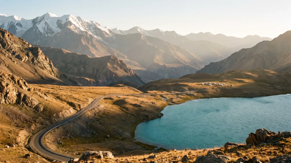
None of that describes what it actually feels like on the ground in the places tourists go. The headline is the Pamir Mountains — the “Roof of the World” — home to Ismoil Somoni Peak at 7,495 metres, the highest point in the former Soviet Union outside the Tian Shan. Tajikistan holds five UNESCO World Heritage Sites, from the Bronze Age proto-city of Sarazm to the enormous Tajik National Park covering the Pamirs’ glaciers and snow-leopard habitat, plus a slice of the transboundary Silk Roads: Zarafshan-Karakum Corridor.
What you’re buying here isn’t polish — it’s scale and hospitality in a country that tourism has barely touched. The catch is real too: the visa needs a bit of homework, GBAO (the Pamir region) requires a separate permit, roads wash out, and the government is authoritarian with a low tolerance for photographing anything security-adjacent. Go in with realistic expectations and Tajikistan delivers some of the most dramatic, least-crowded mountain travel left on the planet.
Navruz — Tajikistan’s Biggest Celebration of the Year
If you can build a trip around one date, make it 21 March, Navruz — the Persian New Year and the biggest holiday on the Tajik calendar, marking the spring equinox and the start of a new agricultural year. Navruz (also spelled Nowruz) is recognised on UNESCO’s Representative List of the Intangible Cultural Heritage of Humanity, alongside Tajikistan’s Shashmaqom classical music tradition and the shared regional dish of palav.
Expect days of street festivals, wrestling and horseback buzkashi matches, communal sumalak (a sprouted-wheat pudding) cooked overnight in huge cauldrons, and families in traditional dress filling the parks of Dushanbe and Khujand. It lands right at the tail of winter, before the high Pamir passes reopen, so pair it with lowland sightseeing — Dushanbe, Khujand, the Fann Mountains foothills — and save the Pamir Highway itself for a return trip in summer.
Best Time to Visit Tajikistan (Season by Season)
May – June · Shoulder green season
Snowmelt fills the rivers, lower valleys turn green, and Fann Mountains trekking opens up while the high Pamir passes are still patchy — some years the M41 fully clears by late May, other years not until June. Fewer travellers than peak summer, but check current pass conditions before committing to a Pamir Highway itinerary this early.
July – September · Peak season
The reliable window for the full Pamir Highway, Bartang and Wakhan valleys, and serious trekking in the Fann Mountains — warm days, cold nights above 3,000 metres, and the only months GBAO’s remoter routes are consistently passable. This is also when the small number of guesthouses along the M41 actually fill up, so book ahead in Khorog and Murghab.
October · Late shoulder
Golden poplars in the lowland valleys, thinning crowds, but an increasing chance of early snow closing the higher passes — a good month for Dushanbe, Khujand and the Fann foothills, riskier for a full Pamir Highway crossing.
November – April · Winter
The Pamir Highway’s high passes close or become unreliable, and GBAO is genuinely hard to reach overland. This is Navruz season and a legitimate, cheap window for the lowland cities, but not the time for Pamir trekking unless you’re an experienced winter mountaineer with a specialist outfitter.
Getting There — DYU, Land Borders & the Osh Route
Dushanbe International Airport (DYU) is the main gateway, a mid-size airport that handled around 2.3 million passengers in 2024, with direct routes concentrated on Russia (Moscow, St. Petersburg and regional cities), Central Asia, the Gulf via flydubai, Turkish Airlines from Istanbul, and China Southern and Loong Air from China. There is no nonstop service from North America or most of Western Europe, so most Western travellers connect through Istanbul, Dubai, or a Central Asian hub like Almaty or Tashkent.
Overland, the classic approach for adventure travellers is the Pamir Highway itself, entering from Osh in Kyrgyzstan via the Kyzyl-Art pass — a spectacular but long, high-altitude border crossing best done with a shared jeep or organized transfer rather than solo hitchhiking on your first attempt. Other land crossings connect to Uzbekistan near Khujand and Panjakent, though border openings can shift with regional politics, so verify current status close to your travel dates. Whichever route you take, sort your e-visa (and GBAO permit, if the Pamirs are on the itinerary) before you leave home — this is not a country where visa-on-arrival is a safe assumption.
Getting Around — Shared Jeeps, Marshrutkas & the Pamir Highway
Tajikistan’s road network is thin and its terrain brutal, so the national vehicle of choice is the shared taxi or 4WD jeep, filled by the seat and departing when full from designated stands in Dushanbe, Khorog and Murghab. The M41 Pamir Highway itself runs roughly 1,252 kilometres between Dushanbe and Osh (Kyrgyzstan), climbing over the Ak-Baital Pass at about 4,655 metres — one of the highest points on any international highway on Earth.
Renting your own 4WD with a driver (roughly US$80–120 a day for vehicle and driver combined, split between however many people you can fit) buys flexibility to stop at hot springs, petroglyphs and village homestays that shared jeeps blow straight past. In Dushanbe and Khujand, city travel means marshrutka minibuses and cheap metered taxis; ride-hailing apps have limited coverage outside the capital. Fuel stops thin out fast past Khorog, so top up whenever you see a station, and expect long, dusty, genuinely spectacular driving days rather than quick hops.
Top Regions — Pamirs, Fann Mountains & Beyond
Dushanbe
The capital and easiest soft landing: leafy Rudaki Avenue, the enormous Dusti (Friendship) flagpole, the National Museum of Tajikistan, and a genuinely good bazaar scene at Mehrgon and Shohmansur markets. Most itineraries start and end here.
Gorno-Badakhshan (GBAO) & the Pamir Highway
The main event — a special administrative region covering nearly half of Tajikistan’s territory that requires its own permit on top of the e-visa. Khorog is the regional capital and a good base for the Botanical Garden (one of the world’s highest) and forays into the Wakhan and Bartang valleys, where Ismaili Pamiri villages, crumbling Silk Road forts and hot springs sit beneath some of the range’s highest peaks.
Wakhan Valley & the Afghan Border
A narrow, dramatically scenic corridor along the Panj River with Afghanistan in plain view across the water — ancient forts, apricot orchards, and hot springs at Bibi Fatima. It sits close to the border areas covered by the elevated Level 3 advisory, so travel here with a reputable local operator and stay current on conditions.
Murghab & the Eastern Pamirs
A high, wind-scoured plateau above 3,600 metres near the Chinese and Kyrgyz borders, dotted with yurt camps and the turquoise expanse of Karakul Lake — about as remote as road travel gets in this part of the world.
Fann Mountains
A trekker’s alternative to the Pamirs, reached easily from Dushanbe or Penjikent, with turquoise alpine lakes (Iskanderkul is the postcard one), granite peaks popular with climbers, and multi-day routes that don’t require a GBAO permit.
Panjakent & Sarazm
Near the Uzbek border, home to the ruins of ancient Panjakent — sometimes called the “Pompeii of Central Asia” — and Sarazm, Tajikistan’s Bronze Age UNESCO World Heritage Site dating to the 4th–3rd millennia BC.
Khujand
Tajikistan’s second city in the fertile Fergana Valley, with a far more Uzbek-inflected feel, a lively Panjshanbe Bazaar, and easier onward access toward Uzbekistan than Dushanbe.
Culture & People — Tajik, Pamiri & Soviet Layers
Ethnic Tajiks make up roughly 86% of the population, an Uzbek minority around 11%, with smaller Kyrgyz and Russian communities. Tajik is a Persian (Farsi) language, which sets the country culturally apart from its Turkic-speaking neighbours — you’ll notice it immediately in the poetry, the architecture and the food. Russian remains widely spoken as the inter-ethnic and business language, a Soviet-era legacy still visible in the concrete apartment blocks and monuments of Dushanbe and Khujand.
In the Pamirs, the picture changes again: most GBAO residents are Ismaili Muslims following the Aga Khan rather than the Sunni majority elsewhere in the country, speaking their own Pamiri languages (Shughni, Wakhi and others) alongside Tajik. Hospitality here runs deep and genuine — homestays are a core part of Pamir travel, not a tourist gimmick, and refusing offered tea or food is a real faux pas. Dress modestly, especially in rural areas and mosques, and always ask before photographing people, checkpoints or anything that looks remotely official.
A Food Lover’s Guide to Tajikistan
The national dish is osh (plov/palav) — rice cooked in fat with carrots, onions and lamb or beef, usually piled onto a communal platter and eaten with your hands or a spoon at celebrations. It’s shared across Central Asia and inscribed on UNESCO’s Intangible Cultural Heritage list as a regional tradition. Everyday staples lean on fresh non (flatbread, treated with real reverence — never place it upside down or throw it away), laghman noodle soup, shurbo meat-and-vegetable broth, and manti dumplings steamed rather than boiled.
Tea (choi) is the default drink and the centrepiece of hospitality — you’ll be poured endless small cups whether you’re in a Dushanbe teahouse or a Pamiri homestay. In the mountains, expect simpler fare built around potatoes, dairy and bread, plus dried apricots and mulberries from the valley orchards in season. Alcohol is available in Dushanbe and larger towns (local vodka and Sultoni beer) but scarcer and more culturally sensitive in rural, more religiously conservative areas — read the room.
Off the Beaten Path
Bartang Valley
A rugged side valley off the Pamir Highway with almost no infrastructure, strung with tiny villages, rope bridges and glacial lakes — a multi-day 4WD or trekking route for travellers who’ve already done the main M41 and want something wilder.
Yagnob Valley
Home to the Yaghnobi people, whose language is a rare living descendant of ancient Sogdian — reachable only by a rough track and foot, with no phone signal and homestays run by families who’ve lived there for generations.
Zorkul Nature Reserve
A high-altitude lake reserve near the Afghan Wakhan Corridor, protecting Marco Polo sheep and snow leopard habitat within the broader Tajik National Park UNESCO site — permits and a guide are essential this close to the border.
Ancient Panjakent’s back streets
Skip the main ruins entrance and wander the mudbrick old town nearby — donkey carts, tandoor bakeries, and barely another foreign face in sight.
Practical Information
Visa & permits. Apply for the e-visa through the official government portal well ahead of travel, and add the GBAO permit at the same time if the Pamirs are on your route — entering GBAO without it risks detention by local authorities. Register your presence if staying beyond the typical short-stay threshold; ask your guesthouse or agency, as rules shift.
Money. The Somoni trades at roughly 9–10 to the US dollar as of mid-2026, and rates move — check the National Bank of Tajikistan’s published rate before a big cash exchange. ATMs are reliable in Dushanbe and Khujand, sparse to nonexistent past Khorog, so carry enough clean, undamaged US dollars or euros in cash for the whole Pamir leg.
Safety. Tourist routes — Dushanbe, the Fann Mountains, the main Pamir Highway corridor — carry a Level 2 “exercise increased caution” US advisory, with Level 3 zones specifically near the Afghan border and occasional past friction near the Kyrgyz border; check current guidance before finalising remote routes. Never photograph checkpoints, military installations or fly a drone near anything official — enforcement is real.
Health. The CDC recommends being current on routine vaccines plus Hepatitis A and B and typhoid for most travellers, with rabies pre-exposure worth considering given the number of street dogs; altitude sickness is the more immediate practical risk on the Pamir Highway, so acclimatise and hydrate.
Connectivity. Mobile data is workable in Dushanbe and Khujand, patchy in Khorog, and effectively absent for long stretches of the Pamir Highway — download offline maps before you leave the capital. Plugs: European two-pin (Type C/F), 220V. Time zone: UTC+5, no daylight saving.
Budget Breakdown — What Tajikistan Actually Costs in 2026
Tajikistan is one of the cheapest countries in Central Asia to travel in day-to-day, but organised Pamir Highway transport is the line item that changes everything.
Budget (US$25–45/day): Homestays or basic guesthouses (often $10–15/night including breakfast and dinner), shared jeep seats between towns, local cafeteria meals for a couple of dollars.
Mid-range (US$60–120/day): Private rooms, a share of a hired 4WD with driver for the Pamir Highway (roughly $80–120/day split between passengers), better restaurants in Dushanbe, occasional domestic flights where available.
Higher-end (US$150+/day): A private vehicle and driver-guide for the full Pamir Highway loop, boutique stays in Dushanbe, specialist trekking or GBAO-region operators handling permits and logistics for you.
Fixed costs to budget for: the e-visa (~$50) and GBAO permit (~$20), and cash reserves for the whole Pamir leg since cards stop working past Khorog. Tipping isn’t deeply ingrained but is increasingly appreciated for drivers and guides.
Planning Your First Trip to Tajikistan
The classic first-timer route is Dushanbe to Osh via the Pamir Highway, or the same route in reverse: two or three nights in Dushanbe to acclimatise and sort logistics, then five to seven days working east through Khorog, the Wakhan Valley, Murghab and over the Ak-Baital Pass into Kyrgyzstan. Ten to fourteen days covers it without rushing the high-altitude sections; add three or four more for the Fann Mountains if trekking is the priority over the full Pamir crossing. Pair it naturally with a Central Asia loop through our Kyrgyzstan guide for the Osh end of the highway, our Uzbekistan guide for the Silk Road cities near Panjakent, or continue further afield with our Kazakhstan guide if you’re routing through Almaty.
Frequently Asked Questions
Is Tajikistan safe for tourists in 2026?
The main tourist corridors — Dushanbe, the Fann Mountains, the core Pamir Highway — carry a Level 2 “exercise increased caution” US advisory, similar to much of the region, with specific Level 3 zones near the Afghan border and past friction near parts of the Kyrgyz border. Travel with a reputable local operator in border-adjacent areas, avoid photographing anything security-related, and check current advisories close to departure.
Do I need a visa, and what’s the GBAO permit?
Most nationalities need Tajikistan’s e-visa, roughly $50 for up to 60 days, applied for online in advance. If your route touches the Pamirs (Gorno-Badakhshan Autonomous Oblast), you also need a separate GBAO permit, about $20 extra, which can be added during the same e-visa application.
Can I do the Pamir Highway without a tour?
Yes — independent travellers regularly do it via shared jeeps and homestays, and it’s one of the cheapest ways to see the route. That said, road conditions, fuel availability and altitude make a hired driver or small organised group considerably more comfortable and safer for a first attempt, especially outside peak summer months.
What altitude issues should I plan for?
The Pamir Highway spends long stretches above 3,500–4,000 metres, cresting at roughly 4,655 metres at Ak-Baital Pass. Build in acclimatisation days, especially if flying straight into Dushanbe and heading up quickly, and take altitude sickness symptoms seriously.
Tajikistan or Kyrgyzstan for mountains?
Choose Tajikistan for higher, starker, more remote terrain and a genuinely rare travel experience; choose Kyrgyzstan for a gentler, more developed trekking and yurt-stay infrastructure. Many travellers do both back-to-back via the Pamir Highway itself, which links Dushanbe to Osh in one trip.
What’s the easiest first taste of Tajikistan if I’m nervous about the Pamirs?
Base yourself in Dushanbe, day-trip to the Fann Mountains or Iskanderkul Lake, and visit Panjakent and Sarazm near the Uzbek border — all reachable without a GBAO permit, and still a real, uncrowded slice of the country.
Ready to Explore Tajikistan?
A highway that tops out near 4,700 metres, homestays where the tea never stops coming, and five UNESCO sites shared with almost nobody — Tajikistan asks a little more of you at the visa stage than most countries, and pays it back many times over on the road. Sort the e-visa and GBAO permit early, build in acclimatisation days, and go while the Pamir Highway is still one of the emptiest great drives left on Earth.
Explore More
- Kyrgyzstan Travel Guide — the other end of the Pamir Highway, via Osh
- Uzbekistan Travel Guide — Silk Road cities just across the border from Panjakent
- Kazakhstan Travel Guide — pair with a wider Central Asia loop
- Mongolia Travel Guide — more remote high-altitude, off-grid travel
How this guide was built
Published as part of Facts From Upstairs’ country guide series. Built from authoritative sources — Tajikistan’s official e-visa portal (evisa.tj), UNESCO’s World Heritage list entries and Tajikistan entity page, the National Bank of Tajikistan’s official exchange rate page, the US State Department and UK FCDO Tajikistan travel advisories, the US CDC traveler page for Tajikistan, Caravanistan’s Tajikistan budget guide, and Wikipedia entity pages for Tajikistan, the Pamir Highway (M41) and Dushanbe International Airport. Numeric and checkable claims carry inline citations.
Sources cited on this page
- Wikipedia — Tajikistan
- Wikipedia — List of World Heritage Sites in Tajikistan
- Tajikistan official e-Visa portal
- National Bank of Tajikistan — official exchange rates
- US State Department — Tajikistan Travel Advisory
- UK FCDO — Tajikistan travel advice
- US CDC — Tajikistan traveler page
- Wikipedia — Dushanbe International Airport
- Wikipedia — M41 highway (Pamir Highway)
- Caravanistan — Tajikistan travel budget guide
More country guides you might like
Plan your trip to Tajikistan
The booking tools we use ourselves. FFU may earn a commission at no extra cost to you.
Plan & book your trip to Tajikistan
Booking through these searches supports our guides at no extra cost to you.