
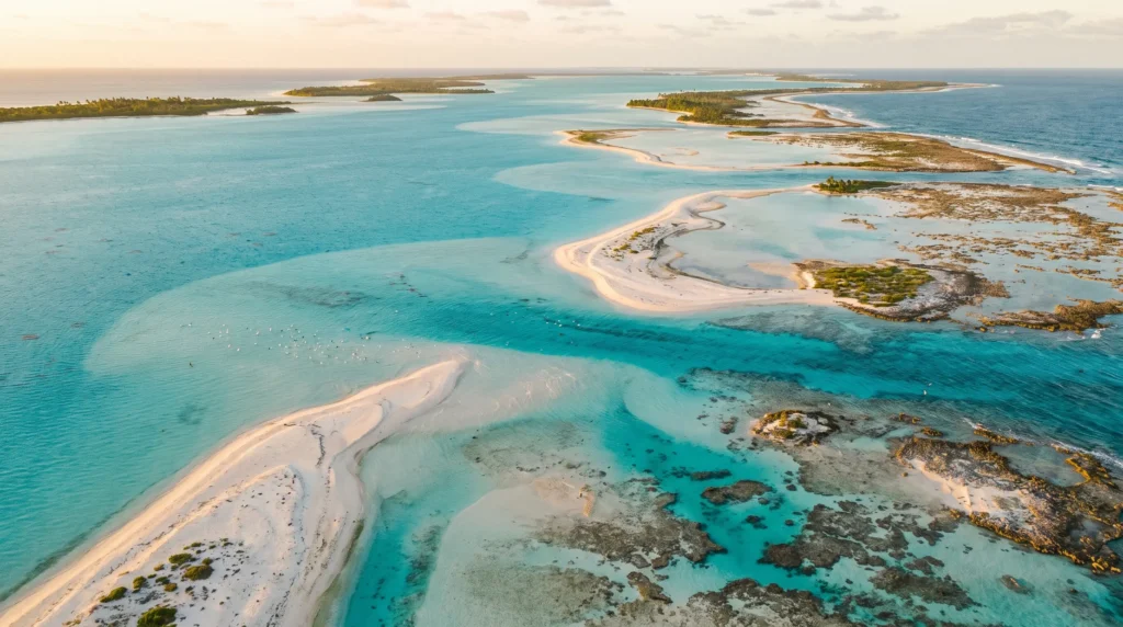
Kiribati Travel Guide — 33 Atolls, One Time Zone Ahead of Everyone Else, and the World’s Loneliest Lagoons
Kiribati (say it “Kiri-bass,” not “Kiribati” — the tourism office will gently correct you within five minutes of landing) is the only country on Earth that sits in all four hemispheres at once, a scatter of 33 coral atolls flung across an ocean area bigger than India, with a land mass you could almost fit inside a mid-sized city. I’m not going to pretend this is an easy trip — flights are sparse, hotels are basic, and you will eat a lot of rice and reef fish — but I am going to tell you why I’d go back tomorrow: bonefish flats the size of small countries, WWII wrecks still rusting quietly on the beach where they fell, and a slowness to daily life that no resort anywhere can fake. This is Pacific travel with the polish sanded off, and for the right kind of traveler that’s the entire point.
In This Guide
- Overview — Why Kiribati Is the Pacific’s Most Scattered Nation
- Independence Day, July 12 — Kiribati’s Biggest Week
- Best Time to Visit Kiribati (Season by Season)
- Getting There — Bonriki, Cassidy & the Long Way Round
- Getting Around — Inter-Island Flights, Boats & Bikes
- Top Regions — Tarawa, Kiritimati & the Outer Islands
- Culture & People — I-Kiribati Life on the Atolls
- A Food Lover’s Guide to Kiribati
- Off the Beaten Path
- Practical Information
- Budget Breakdown — What Kiribati Actually Costs in 2026
- Frequently Asked Questions
Overview — Why Kiribati Is the Pacific’s Most Scattered Nation
Kiribati is what happens when a country is built almost entirely of ocean. Thirty-two atolls plus the raised island of Banaba add up to just 811 square kilometres of land — smaller than New York City — but that land is spread across roughly 3.4 million square kilometres of Pacific, an exclusive economic zone bigger than India. The country is split into three groups: the Gilbert Islands in the west (where most people live and where you’ll land), the Phoenix Islands in the middle (mostly uninhabited, mostly protected ocean), and the Line Islands in the east, which includes Kiritimati — Christmas Island — the largest coral atoll on the planet by land area.
Independent from Britain since 1979, Kiribati is a parliamentary republic of roughly 138,000 people, the vast majority ethnically Gilbertese and Christian. There is no real tourism industry here in the sense you’d recognize from Fiji or Bali — no resort strip, no cruise piers, no all-inclusive anything. What there is: some of the emptiest bonefishing flats on Earth, WWII battle sites frozen in place since 1943, and a genuine, unhurried welcome once you’ve made the effort to actually arrive.
I want to be straight about the trade-off up front, because Alex-the-honest-friend voice matters more here than anywhere else I’ve written about: Kiribati is remote, flights are unreliable, and this is not a place for travelers who need things to run on schedule. If that sounds like a dealbreaker, it probably is. If it sounds like the whole appeal, keep reading.
Independence Day, July 12 — Kiribati’s Biggest Week
Time a July visit around 12 July, Independence Day, marking the country’s 1979 break from Britain. South Tarawa spends the surrounding week on a genuine high: church services, traditional dance competitions (te mwaie), canoe races in the lagoon, and communal feasts spilling out of the maneaba, the open-sided meeting houses that anchor every village. It’s the one week of the year when the whole country — spread across a thousand miles of ocean — feels like it’s celebrating the same thing at the same time.
Land during this week and expect Bonriki’s tiny single-runway airport to feel briefly busy by Kiribati standards, and expect every guesthouse on South Tarawa to be booked out with i-Kiribati returning home from Fiji, Nauru and beyond for the holiday. Book weeks ahead if this is your window — not because there’s real competition for beds, but because there are so few of them.
Best Time to Visit Kiribati (Season by Season)
April – October · Drier, calmer window
The safest weather bet, outside the main cyclone risk window and generally drier across the Gilbert Islands. This is also the stretch most fly-fishing operators on Kiritimati run at full capacity, so book lodges months ahead.
November – April · Cyclone season
Kiribati sits closer to the equator than most Pacific cyclone tracks, so direct hits are rarer than in Fiji or Vanuatu, but strong winds and squalls are common and travel insurance with evacuation cover is non-negotiable. Inter-island flights get cancelled more often in this window — build slack into any itinerary that depends on a domestic connection.
Year-round reality check
Kiribati straddles the equator, so there isn’t a dramatic hot/cold seasonal swing — it’s warm and humid essentially all year. The variable that actually matters for planning isn’t temperature, it’s flight reliability, which is better April through October.
Getting There — Bonriki, Cassidy & the Long Way Round
Bonriki International Airport (TRW), on South Tarawa in the Gilbert Islands, is the country’s main gateway. Fiji Airways connects it to Nadi, and Nauru Airlines links Tarawa to Nauru, Brisbane, Majuro, Koror and Pohnpei — routes that run a handful of times a week, not daily. For most Western travelers the realistic route is a long-haul flight to Nadi, Fiji, then onward on Fiji Airways — treat Fiji as your practical staging post for the whole trip, both for flights and for the fact that the nearest US and UK embassy support for Kiribati is based in Suva.
Kiritimati (Christmas Island) in the Line Islands is a separate entry point entirely, served by Cassidy International Airport (CXI) with its own limited connections toward Honolulu — roughly 2,160 kilometres south of Hawaii. There is no scheduled service between Tarawa and Kiritimati that makes same-trip hopping straightforward; most visitors pick one or the other rather than trying to combine them on a single itinerary. Build a buffer day on both ends of any Kiribati trip — “commercial service to Kiribati is sporadic,” in the US State Department’s own phrasing, and that’s the single most important planning fact in this whole guide.
Getting Around — Inter-Island Flights, Boats & Bikes
Domestic carriers Air Kiribati and Coral Sun Airways connect Bonriki to sixteen other airstrips across the Gilbert Islands, though not every route flies directly or frequently. On South Tarawa itself, a single road strings the islets together from Betio in the southwest up to Bonriki and Tanaea — buses (converted trucks, really), taxis and rented bikes cover it easily, and the whole strip is narrow enough that you’re rarely more than a short ride from the lagoon or the ocean side.
Between outer islands, inter-island boats and the government shipping schedule are the backup to flights that get cancelled — expect this to take patience, not planning. Roads outside South Tarawa are minimal to nonexistent; on the outer islands and North Tarawa, walking, biking and small boats are simply how you move. Driving at night is discouraged countrywide due to poor lighting and road conditions.
Top Regions — Tarawa, Kiritimati & the Outer Islands
South Tarawa
The capital area and the country’s population centre by a huge margin — roughly 73,000 people packed onto a strip of islets averaging only 450 metres wide, giving it a population density that rivals major world cities. This is where you land, where most guesthouses and government offices are, and where the WWII history at Betio is most accessible. It is also genuinely overcrowded, with water supplied to most villages for only a couple of hours every other day — worth knowing before you arrive expecting resort-standard plumbing.
Betio
The westernmost islet of Tarawa and the site of the brutal November 1943 Battle of Tarawa. Rusting Japanese gun emplacements, beached landing craft and tank hulks still sit where they fell, alongside war cemeteries — Betio’s is the largest of 37 on Tarawa. It’s a sobering, low-key historical site with none of the visitor infrastructure of a place like Normandy — just the relics, largely as the tide and the decades left them.
North Tarawa
A short boat or causeway trip from the crowded south into a quieter, more traditional stretch of the same atoll — village life, maneaba meeting houses, and lagoon fishing without the density of the capital.
Kiritimati (Christmas Island)
The Line Islands’ giant: at over 312 square kilometres it’s the largest coral atoll on Earth by land area, home to around 7,400 people and a small, dedicated fly-fishing scene chasing bonefish and giant trevally across huge shallow flats. It also holds a genuine novelty: sitting in UTC+14, it’s one of the first inhabited places on the planet to see each new day.
The Phoenix Islands
Almost entirely uninhabited and largely inaccessible to casual tourism, this group sits inside the Phoenix Islands Protected Area — at 408,250 square kilometres, one of the largest marine protected zones ever designated, inscribed by UNESCO in 2010 for its intact coral archipelago ecosystems, seamounts and tuna spawning grounds. Worth knowing honestly: Kiribati reopened part of the area to commercial fishing in 2023, a reminder that conservation status on paper doesn’t always survive contact with a small economy that depends on fishing revenue. Visiting requires a private yacht charter or a rare liveaboard expedition — this is not a day-trip region.
Outer Gilbert Islands
Abaiang, Abemama, Butaritari, Tabiteuea and the rest — reachable by the limited domestic flight network or inter-island boat, these are where “off the beaten path” stops being a marketing phrase and just becomes accurate. Expect village homestays over hotels, and to be one of very few outside visitors on the island.
Culture & People — I-Kiribati Life on the Atolls
Kiribati’s population is remarkably homogenous for a Pacific nation — about 96% ethnically Gilbertese (i-Kiribati) and roughly the same share Christian, predominantly Catholic. Both English and Gilbertese are official languages, and English is widely spoken in Tarawa’s guesthouses and government offices, though Gilbertese dominates daily life on the outer islands.
The maneaba — an open-walled, thatch-roofed meeting house — is the social heart of every village, used for everything from council meetings to weddings to dance performances. Te mwaie, Kiribati’s traditional standing dance performed to chanted song, is the cultural centrepiece you’re most likely to see performed for visitors, especially around Independence Day. A simple “Mauri” (roughly “good health to you”) is the standard greeting and goes a long way. Communities here are tight-knit and visibly proud, but also visibly living with the daily reality of a country whose highest points sit barely above the tide — climate change isn’t an abstraction in Kiribati, it’s dinner-table conversation.
A Food Lover’s Guide to Kiribati
Fish is the constant — reef fish and tuna grilled, boiled or eaten raw with lime and coconut cream in a dish similar to the Pacific-wide “poisson cru” style. Coconut in every form (meat, milk, toddy) and imported rice round out most plates, alongside babai, a giant swamp taro grown in dug pits that’s treated as a prestige food for feasts and celebrations.
Don’t expect much of a restaurant scene outside a handful of South Tarawa hotels and Chinese-run eateries — most food on the outer islands is what your homestay family caught or grew that day, which is honestly one of the better reasons to go. Bring a reusable water bottle and purifying drops; bottled water isn’t reliably available once you’re off South Tarawa.
Off the Beaten Path
Kiritimati’s fly-fishing flats
A specialist pilgrimage rather than a mainstream stop — anglers fly in specifically for the bonefish and giant trevally across Kiritimati’s vast shallow lagoon flats, staying at a small number of dedicated fishing lodges. Even by Kiribati standards this is a niche, expensive, book-far-ahead trip.
Betio’s WWII battlefield
No museum, no gift shop, no entrance fee — just the actual gun emplacements, wrecked landing craft and cemeteries from the November 1943 battle, sitting largely undisturbed on the beach and in the scrub. Go with a local guide who can explain what you’re looking at; the sites themselves carry no signage to speak of.
Outer island homestays
Abaiang or Butaritari for a few nights, arranged through the Kiribati National Tourism Office or a South Tarawa contact, put you inside village life rather than observing it — no wifi, no menu, just the rhythm of an atoll that sees a handful of outside visitors a year.
The Phoenix Islands by yacht
For sailors and serious liveaboard divers only: one of the remotest, least-visited marine wildernesses left on the planet, reachable by private charter alone.
Practical Information
Money. The Australian Dollar (AUD) is the everyday currency — Kiribati has no independent currency of its own. Cards are rarely accepted outside a few South Tarawa hotels; bring cash, and note that travelers may carry in a maximum of AUD 5,000 without declaring it, with no restriction on the way out.
Safety. The US State Department rates Kiribati Level 1, “Exercise Normal Precautions,” its lowest advisory tier, and describes the crime rate as low — though ordinary vigilance with valuables still applies. The bigger practical risks are natural, not criminal: cyclone-season winds, plus real earthquake and tsunami exposure given the Pacific setting. Check your government’s current advisory before you fly, since guidance and disruption notices change.
Health. Medical facilities are limited nationwide, with the State Department flatly describing hospital accommodations as inadequate and advanced equipment lacking — comprehensive travel insurance with medical evacuation coverage is essential, not optional. The CDC recommends being current on routine vaccines plus Hepatitis A, Hepatitis B and typhoid for most travelers, and flags dengue, Zika and leptospirosis as regional risks worth insect precautions and caution around standing water. Drink only treated or bottled water.
Connectivity. Internet is slow and limited even on South Tarawa and effectively absent on outer islands — come with offline maps and lowered expectations. Plugs: Australian/NZ-style three-pin, 240V. Time zone: UTC+12 for the Gilbert Islands, UTC+13 for the Phoenix group, and UTC+14 on Kiritimati — genuinely three time zones inside one small country.
Budget Breakdown — What Kiribati Actually Costs in 2026
Kiribati isn’t cheap, and the reason isn’t luxury — it’s scarcity. Almost everything beyond fish and local produce is imported, and flights in and out are a major line item regardless of budget tier.
Budget (US$70–120/day): Simple South Tarawa guesthouse, local food (fish, rice, seasonal produce), buses/taxis over rentals, no domestic flights.
Mid-range (US$150–300/day): A better South Tarawa hotel or an outer-island homestay package, one or two domestic flights, a local guide for Betio’s WWII sites, some restaurant meals.
Splurge (US$400+/day): Kiritimati fly-fishing lodge packages (rods, guides and full board bundled in, and priced accordingly), or a private yacht charter into the Phoenix Islands.
Fixed costs to plan around: international flights are the single biggest expense and the least flexible on price; domestic flights within Kiribati aren’t cheap either given the tiny passenger volumes. Budget slack days into every itinerary — schedule changes are the norm, not the exception.
Planning Your First Trip to Kiribati
The realistic first-timer route: fly into Nadi, Fiji, connect on Fiji Airways to Tarawa, and spend four or five nights based on South Tarawa — Betio’s WWII relics, a North Tarawa day trip, and time to simply adjust to island pace. If fly-fishing or true remoteness is the draw, treat Kiritimati as a separate, dedicated trip through its own limited connections rather than trying to bolt it onto a Tarawa itinerary. Given how few flights a week actually run, build at least one buffer day on each end, and consider pairing the trip with time in Fiji or onward to Samoa so a missed connection doesn’t sink the whole holiday. Seven to ten days is realistic for a single-atoll-group trip; don’t try to do Tarawa and Kiritimati in one visit unless you have real flexibility.
Frequently Asked Questions
Is Kiribati safe for tourists in 2026?
Yes, by the numbers — the US State Department places it at Level 1, its lowest advisory tier, and describes crime against tourists as low. The real risks are logistical and environmental (unreliable flights, cyclone-season weather, limited medical care) rather than personal safety, so insure accordingly and check current advisories before departure.
Do I need a visa?
Most Western passport holders, including US citizens, get visa-free entry for stays up to 30 days, provided you carry a passport valid at least six months, an onward or return ticket, and proof of sufficient funds.
How do I actually get to Kiribati?
Almost everyone routes through Nadi, Fiji, and connects on Fiji Airways into Bonriki (Tarawa). Kiritimati is reached separately, typically via limited connections toward Honolulu. Flights are infrequent in both directions, so build buffer time into your plans.
What’s the deal with Kiribati and climate change?
It’s not tourist-brochure talk — most of the country sits less than three metres above sea level, and the IPCC’s mid-century sea-level projections are an existential planning issue for the government, not an abstraction. Visit with that context in mind, and don’t expect a theme-park version of paradise; expect a country having a very real conversation about its own future.
Kiribati or Fiji for a first Pacific trip?
Choose Fiji for developed resorts, easy flights and a gentler intro to the Pacific. Choose Kiribati only if remoteness, WWII history or serious fly-fishing are the actual draw — this is an add-on or a deliberate deep-dive, not a beginner’s Pacific island.
Can I combine Kiribati with other Pacific destinations?
Yes, and you basically have to, given flight frequency. Fiji is the natural hub for connections in both directions, and some travelers loop onward toward Nauru or the Marshall Islands on the same Nauru Airlines network that serves Tarawa.
Ready to Explore Kiribati?
This isn’t a trip you fall into on a whim — it takes real planning, patience with a thin flight schedule, and a willingness to trade comfort for genuine isolation. In return you get bonefish flats nobody else is standing on, WWII history with no velvet rope around it, and villages where a stranger showing up is still an event. If that trade sounds right to you, start with Fiji, book your onward flight early, and go before the tide the rest of the world talks about actually decides the itinerary for you.
Explore More
- Fiji Travel Guide — the practical gateway to Kiribati and an easier Pacific first stop
- Samoa Travel Guide — more Pacific island culture, easier to reach
- Australia Travel Guide — the region’s other major air hub and currency link (Kiribati uses the Australian Dollar)
- New Zealand Travel Guide — for extending a South Pacific trip further
How this guide was built
Published as part of Facts From Upstairs’ country guide series. Built from authoritative sources — the Kiribati National Tourism Office (kiribatitourism.gov.ki), the US State Department’s Kiribati travel information page, the US CDC traveler page for Kiribati, the UK FCDO Kiribati travel advice, and Wikipedia entity pages for Kiribati’s geography and government, the Phoenix Islands Protected Area, Bonriki International Airport, the Battle of Tarawa, Kiritimati, and South Tarawa. Numeric claims carry inline citations; where a specific figure could not be verified against a primary or authoritative source, it is described qualitatively instead.
Sources cited on this page
More country guides you might like
Plan your trip to Kiribati
The booking tools we use ourselves. FFU may earn a commission at no extra cost to you.
Plan & book your trip to Kiribati
Booking through these searches supports our guides at no extra cost to you.