
Marshall Islands Travel Guide — Bikini Atoll’s Sunken Fleet, the World’s Largest Lagoon & a Nation Made of Water
I’ll say the quiet part first: almost nobody reading this has been to the Marshall Islands, and almost nobody who goes regrets it. This is a country built from 29 coral atolls and 5 islands scattered across a slice of the central Pacific roughly the size of Mexico — yet all that land, if you could pile it up, covers barely 181 square kilometers. Everything else is lagoon, and one of those lagoons, Kwajalein’s, is the largest on Earth. This is also the place where the United States detonated 67 nuclear weapons between 1946 and 1958, including the first hydrogen bomb — and where you can now scuba dive an aircraft carrier and a fleet of Japanese and American warships resting on the lagoon floor at Bikini Atoll, a UNESCO World Heritage Site precisely because of what happened there. None of this is easy to get to, none of it is cheap once you arrive, and the islands themselves are quietly running out of time to sea-level rise. Go anyway, with open eyes about all three of those things — this is not a trip you back into by accident, and that’s exactly what makes it worth planning on purpose.
In This Guide
- Overview — A Country That’s 98% Lagoon
- Manit Day — Marshallese Culture Day
- Best Time to Visit the Marshall Islands
- Getting There — the Island Hopper & the Only Way In
- Getting Around — Field Trip Ships, Puddle-Jumpers & Feet
- Top Atolls — Majuro, Bikini, Kwajalein & Beyond
- Culture & People — Navigators, Weavers & a Nuclear Legacy
- A Food Lover’s Guide to the Marshall Islands
- Off the Beaten Path
- Practical Information
- Budget Breakdown — What the Marshall Islands Actually Costs
- Frequently Asked Questions
Overview — A Country That’s 98% Lagoon
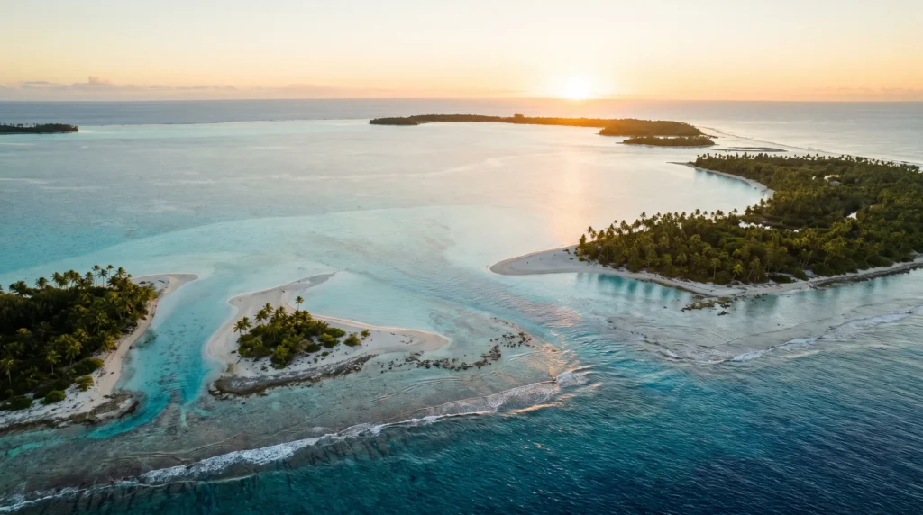
The Republic of the Marshall Islands sits in the central Pacific roughly halfway between Hawaii and the Philippines, split into two parallel chains — the Ratak (“sunrise”) chain to the east and the Ralik (“sunset”) chain to the west — made up of 29 coral atolls and 5 standalone islands, plus around 1,220 smaller islets. Total land area is minuscule, about 181 square kilometers, but the lagoons enclosed by those reefs sprawl across tens of thousands of square kilometers of turquoise water. It is one of only four atoll nations on the planet, alongside Kiribati, Tuvalu and the Maldives, and nowhere on Earth sits more than a few meters above sea level.
Politically, the country is an independent UN member state that governs itself while holding a Compact of Free Association with the United States — a deal, recently extended through 2043, that provides US funding and services in exchange for exclusive American military access, including the missile-testing range at Kwajalein Atoll. That relationship also explains why the US dollar is the only currency, why English is co-official with Marshallese, and why the country’s modern history is inseparable from the Cold War: 67 nuclear weapons were detonated here between 1946 and 1958, and Bikini Atoll — ground zero for the largest of them — is today a UNESCO World Heritage Site precisely because its sunken fleet and blast craters are treated as tangible evidence of the nuclear age.
None of that history has stopped the Marshall Islands from being, quite simply, gorgeous — hyper-clear water, some of the healthiest reef and shark populations left in the Pacific (the country runs the world’s largest shark sanctuary, at roughly 2 million square kilometers ), and a level of remoteness that means you’ll often have an entire reef, wreck or islet to yourself. What it isn’t is a resort destination: infrastructure is thin, flights are infrequent and pricey, and this is a trip for travelers who want the story as much as the scenery.
Manit Day — Marshallese Culture Day
Time a September trip around the last Friday of the month, when the country marks Manit Day — Marshallese Culture Day, a national holiday devoted entirely to keeping traditional knowledge alive. Expect outrigger canoe races, traditional dance and chant competitions, demonstrations of the stick-chart navigation that let Marshallese wayfinders read ocean swells for centuries before GPS, and stalls of handwoven pandanus mats and jaki-ed textiles. It’s the single best window into Marshallese identity for a visitor, and it’s mostly a local affair rather than a tourist show — arrive with curiosity and you’ll be welcomed.
The same week in early September brings Dri-Jerbal Day (Workers’ Day, first Friday of the month), and the whole late-September stretch tends to have a festive, family-gathering feel across Majuro and the outer atolls. Book flights well ahead — outer-island transport gets busy as families travel in for the celebrations.
Best Time to Visit the Marshall Islands
December – April · Dry season (best diving visibility)
The most reliable stretch of weather, with the lightest rainfall of the year and the calmest seas for atoll-hopping and wreck diving at Bikini. Temperatures barely move year-round — this close to the equator, Majuro sits around 25–30°C (78–87°F) in every month — so “dry season” is really about rainfall and sea state, not heat.
May – July · Transitional
Rain becomes more frequent but still arrives mostly as short tropical showers rather than all-day systems. Good value window before the wettest months set in.
August – November · Wet season & typhoon watch
October and November are typically the rainiest months of the year, and this stretch also carries the highest — though still statistically low — risk of tropical storms in the wider western Pacific. Travel insurance with weather-disruption cover is a sensible non-negotiable if you’re visiting in this window, and outer-island field-trip ship schedules can slip further than usual.
Getting There — the Island Hopper & the Only Way In
There is exactly one practical way to fly to the Marshall Islands: United Airlines’ famous “Island Hopper,” flight UA154/155, which links Honolulu to Guam (and vice versa) via a chain of Micronesian stops that includes Majuro and, on the full routing, Kwajalein, Kosrae and Pohnpei. The Honolulu–Majuro leg alone runs about 4.5 hours, and the Hopper operates only a few times a week, so this is a trip that has to be built around the schedule, not the other way around. Amata Kabua International Airport (MAJ) in Majuro is the country’s main gateway; a US$20 departure fee applies to outbound international travelers aged 13–59.
One quirk worth knowing before you book: if your itinerary touches down at Kwajalein, you cannot disembark there without prior US government authorization, since the airfield sits inside an active missile-defense installation. Most leisure travelers simply stay aboard through that stop and continue to Majuro. Because flights are infrequent and seats limited, book the Hopper segment months ahead, especially around Manit Day in September and the Christmas/New Year period.
Getting Around — Field Trip Ships, Puddle-Jumpers & Feet
Majuro itself is walkable and taxi-friendly along its single main road, Delap-Uliga-Djarrit (DUD), but getting to the outer atolls is a different exercise entirely. Air Marshall Islands runs small domestic flights to a handful of outer airstrips, though schedules are limited and subject to change — always build in buffer days. The more traditional option is government-run “field trip ships,” slow supply vessels that circuit the outer atolls carrying cargo, mail and passengers; they’re cheap, atmospheric, and genuinely unpredictable in timing.
For Bikini Atoll and other historic dive sites, the realistic route is a specialist liveaboard dive vessel departing from Majuro or Kwajalein rather than any scheduled transport — this is expedition travel, and operators handle the permits and logistics as part of the package. Within Ebeye and the outer atolls, walking, bicycles and the occasional shared pickup truck cover most local distances.
Top Atolls — Majuro, Bikini, Kwajalein & Beyond
Majuro Atoll
Home to roughly half the country’s population and its only real urban center, Majuro is a long, thin strip of land wrapped around a lagoon, with the capital’s DUD corridor holding most hotels, government offices and restaurants. It’s not a beach-resort town — think working Pacific capital rather than postcard — but it’s the necessary hub for onward travel and has decent snorkeling right off its ocean-side reef.
Bikini Atoll
The country’s most famous — and most sobering — destination: site of 23 nuclear tests including the 1954 Castle Bravo hydrogen bomb, and now a UNESCO World Heritage Site for the sunken fleet resting in its lagoon, among them the aircraft carrier USS Saratoga. Advanced wreck divers reach it exclusively via seasonal liveaboard expeditions; the original Bikini islanders remain unable to permanently resettle the atoll due to residual contamination.
Kwajalein Atoll
The largest atoll on Earth by lagoon area — about 2,850 square kilometers of enclosed water — and home to both a small US Army missile-defense installation on Kwajalein Island and the Marshallese community of Ebeye, one of the most densely populated small islands in the world. Access to the US base side is restricted; independent travelers generally experience Kwajalein Atoll via Ebeye or by boat from outer islets rather than the base itself.
Arno Atoll
A short boat hop from Majuro, Arno is the easiest “outer island” taste of traditional Marshallese life — fishing villages, quiet lagoons and a relaxed pace, without the logistics of a multi-day field-trip-ship journey.
Jaluit Atoll
Once the German and Japanese colonial administrative center, Jaluit still holds crumbling Japanese-era fortifications and a UNESCO-recognized biosphere reserve status for its lagoon ecosystem, alongside strong bonefishing on its flats.
Enewetak Atoll
The other major nuclear test site, Enewetak carries its own heavy history — including the Runit Dome, a concrete containment structure built over irradiated soil — plus, further from the dome, some of the country’s most pristine and least-visited diving.
Wotje & the Northern Ratak Chain
Scattered WWII-era Japanese ruins, some of the country’s prettiest untouched beaches, and essentially no tourist infrastructure — this is where the field-trip ship earns its reputation as an adventure in itself.
Culture & People — Navigators, Weavers & a Nuclear Legacy
Marshallese culture is built on two ancient skills the islands demanded: long-distance ocean navigation and making the most of very little land. For centuries, Marshallese navigators read wave patterns and swells well enough to sail between distant atolls without instruments, a body of knowledge encoded in stick charts — frameworks of coconut-midrib and shell that mapped ocean swell patterns rather than serving as charts to carry aboard; they were studied and memorized on land, then left behind. That knowledge is now taught deliberately to keep it alive, and Manit Day is the best showcase of it for visitors.
The greeting you’ll hear constantly is “yokwe” — hello, goodbye and love rolled into one word, the Marshallese cousin of Hawaiian “aloha.” Land and social structure run through a matrilineal clan system, and finely woven pandanus-leaf mats and jaki-ed textiles remain a prestige craft and common gift.
The other current running through modern Marshallese identity is the nuclear legacy: 67 tests over twelve years displaced entire island populations, some of whom — like the people of Bikini — still cannot safely return home. March 1’s Nuclear Victims Remembrance Day is a national holiday, and it’s a subject Marshallese people discuss openly and without prompting — approach it as the significant, still-unresolved part of the national story that it is, not as trivia.
A Food Lover’s Guide to the Marshall Islands
Marshallese food runs on what the atolls can actually produce: fish and other seafood, rice, and anything made from coconut, breadfruit, pandanus, taro, arrowroot and papaya. Reef fish and tuna, often grilled or made into fresh sashimi given the quality of the local catch, are the backbone of most meals, and coconut turns up everywhere — grated into rice, pressed into milk for stews, or scraped straight from the shell as a snack.
Breadfruit (ma) and pandanus (bob) are prepared in dozens of ways, from baked and mashed to fermented preparations that keep well without refrigeration — a practical necessity on islands with limited power and cold storage. Majuro’s small restaurant scene mixes Marshallese staples with Japanese, Filipino and American imports (a legacy of trade routes and the US military presence), so expect sushi counters and burger joints alongside local fish markets. Imported goods cost noticeably more than on a typical Pacific island given the distances involved, so a lot of budget travel here means eating what the ocean and the atoll actually provide.
Off the Beaten Path
The Sunken Fleet of Bikini Lagoon
Diving the USS Saratoga and the other wrecks scuttled during 1946’s Operation Crossroads tests is about as far off the beaten path as recreational diving gets — advanced-certification liveaboard expeditions only, run a handful of times a year, and priced accordingly.
Ebeye, Kwajalein Atoll
One of the most densely populated small islands on the planet sits right beside a restricted US military base — a genuinely striking contrast, and a window into contemporary Marshallese urban life that almost no visitor sees.
Field-Trip-Ship Circuits
Booking passage on a government supply vessel out to Wotje, Maloelap or the northern Ratak atolls is slow, uncomfortable at times, and about as authentic an outer-island experience as exists anywhere in the Pacific.
Arno Atoll Bonefishing & Village Stays
Close enough to Majuro for a manageable trip, remote enough that you’ll likely be the only outsider around.
Practical Information
Money. The US dollar is the only currency in circulation, so there’s no exchange rate to think about for American visitors, and no local currency to convert for anyone else. ATMs and card acceptance are effectively limited to Majuro and Ebeye — carry cash for outer-island travel.
Safety. The US State Department rates the Marshall Islands at its lowest advisory tier, Level 1: Exercise Normal Precautions, reflecting a generally very safe environment for visitors. The practical risks here are logistical and environmental — flight schedule slips, storm disruption, limited medical care — rather than crime.
Health. Medical facilities are limited to public clinics in Majuro and Ebeye, and serious medical evacuations are both common necessities and expensive, frequently exceeding US$100,000, so comprehensive travel and medevac insurance is essential rather than optional. Tap water isn’t reliably safe to drink; stick to bottled or treated water, and avoid swallowing water while swimming in Majuro’s lagoon, which has tested positive for E. coli in places. Proof of measles vaccination is required for entry for eligible travelers.
Connectivity. Internet is slow and expensive by global standards outside Majuro’s main hotels; expect outer atolls to have minimal or no connectivity at all. Plugs: US-style, 110V. Time zone: UTC+12, no daylight saving.
Budget Breakdown — What the Marshall Islands Actually Costs
This is not a backpacker-cheap destination — remoteness and reliance on imports push prices well above the Pacific-island average, before you even factor in the cost of getting here.
Budget (US$70–130/day): Simple Majuro guesthouse, local fish-and-rice meals, walking or shared local transport, skipping outer-atoll flights.
Mid-range (US$180–320/day): A standard Majuro hotel, restaurant meals mixing local and imported food, a domestic flight or field-trip-ship berth to one outer atoll, snorkeling day trips.
Splurge (US$600+/day): A multi-day Bikini Atoll liveaboard dive expedition — the headline experience of the country, and priced as the specialist, permit-gated operation that it is.
Fixed costs to plan around: the international departure fee at Majuro’s airport, and the Island Hopper flight itself, which is rarely a bargain fare given how few carriers serve the route.
Planning Your First Trip to the Marshall Islands
Most first-timers build the trip around the Island Hopper’s own schedule rather than the other way around: fly Honolulu–Majuro, spend three or four nights based in the capital with a day trip to Arno Atoll, then — only if diving is the priority and budget allows — book a specialist Bikini Atoll liveaboard separately, since it rarely aligns neatly with a short Majuro stay. Because this is genuinely remote travel, pair it mentally with other Pacific stops rather than treating it as a standalone week: many visitors route through Fiji or continue on to Samoa for a more developed island-resort leg of the same Pacific trip, and history buffs often combine it with Japan, given the shared WWII-era Pacific story between the two.
Frequently Asked Questions
Is the Marshall Islands safe to visit in 2026?
Yes — the US State Department rates it at its lowest advisory level, Level 1: Exercise Normal Precautions. The real challenges are logistical (infrequent flights, limited medical care) rather than safety-related.
Do I need a visa?
US citizens can enter visa-free for up to 90 days under the Compact of Free Association. Most other visitors, including UK, EU, Australian, New Zealand and Japanese passport holders, receive a free visa on arrival, also typically valid for 90 days, though proof of onward travel and funds may be requested.
Can I visit Bikini Atoll, and is it radioactive?
You can dive Bikini’s lagoon via specialist liveaboard expeditions, but the atoll’s islands themselves remain off-limits for permanent resettlement due to residual radioactive contamination from the 1946–1958 test program, and access is tightly controlled by the Bikini local government. This is expedition-grade travel, not a casual add-on.
Is the Marshall Islands sinking?
Almost the entire country sits barely above sea level, and rising seas are a genuine, actively discussed existential threat to the nation — this isn’t tabloid framing, it’s a topic the Marshallese government raises constantly in international climate forums. It’s a real reason some travelers choose to prioritize a visit sooner rather than later.
How do I actually get there?
Essentially one route: United Airlines’ Island Hopper (UA154/155) linking Honolulu and Guam via Majuro, running only a few times weekly. There is no other scheduled international air service to speak of, so flexibility around the Hopper’s schedule is essential.
What’s the easiest first outer-island trip?
Arno Atoll — close enough to Majuro for a day or overnight trip without committing to a multi-day field-trip-ship circuit, and a genuine taste of outer-atoll life.
Ready to Explore the Marshall Islands?
A capital you can walk end to end, a sunken WWII fleet resting in the world’s most storied lagoon, stick-chart navigators’ descendants still teaching the craft on Manit Day, and reef water so clear it looks retouched. The Marshall Islands ask more of you logistically than almost anywhere else in the Pacific — and give back a trip nobody else you know will have taken.
Explore More
- Fiji Travel Guide — a more developed Pacific island stop to pair with the Marshalls
- Samoa Travel Guide — Polynesian culture and easier island infrastructure
- Japan Travel Guide — the other side of the shared WWII Pacific history
- New Zealand Travel Guide — Oceania’s most-visited anchor destination
How this guide was built
Published as part of Facts From Upstairs’ country guide series. Built from authoritative sources — UNESCO’s Bikini Atoll Nuclear Test Site World Heritage inscription, the US State Department’s Marshall Islands country and travel advisory pages, the US CDC traveler page for the Marshall Islands, the Smithsonian Institution’s overview of Micronesian stick-chart navigation, and Wikipedia entity pages covering the Marshall Islands, Bikini Atoll, Kwajalein Atoll, Marshallese culture, the Island Hopper flight route and Marshall Islands public holidays, cross-checked against a specialist climate reference for seasonal rainfall patterns. Numeric and checkable claims carry inline citations.
Sources cited on this page
- Wikipedia — Marshall Islands
- UNESCO — Bikini Atoll Nuclear Test Site
- Wikipedia — Bikini Atoll
- Wikipedia — Kwajalein Atoll
- Wikipedia — Island Hopper (United Airlines)
- Wikipedia — Culture of the Marshall Islands
- Wikipedia — Public Holidays in the Marshall Islands
- Smithsonian Ocean — Micronesian Stick Charts
- US State Department — Marshall Islands Travel Advisory
- US State Department — Marshall Islands Country Information
- US CDC — Marshall Islands Traveler Page
- VisaVerge — Marshall Islands Visa Guide 2026
- Climates to Travel — Marshall Islands Climate
More country guides you might like

Plan your trip to Marshall Islands
The booking tools we use ourselves. FFU may earn a commission at no extra cost to you.
Plan & book your trip to Marshall Islands
Booking through these searches supports our guides at no extra cost to you.